| . |  |
. |
| . | |
. |
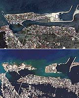
Washington DC (UPI) Dec 28, 2004 Earthquake and tsunami specialists working for the U.S. National Weather service and other agencies, at home and abroad, reacted with lightning speed to the huge earthquake that struck off the northwest tip of the island of Sumatra early Sunday morning. Using a network of sensors carried by buoys and lying all over the bottom of the Pacific Ocean, as well as the most sophisticated computer models available, scientists at the Pacific Tsunami Warning Center in Hawaii issued a bulletin a mere 16 minutes after the quake had struck. This would have been plenty of time for local coastal authorities to send out tsunami warnings to citizens to get to higher ground before the powerful waves hit. Except the quake -- which registered a 9.2 magnitude on the Richter scale and constituted the strongest one recorded since the same-sized great Alaska temblor in 1964 -- occurred in the Indian Ocean, not the Pacific. There was no threat of a tsunami resulting from the quake anywhere in the Pacific basin. The Indian Ocean basin, however, as emerging news reports are showing, turned out to be a different story. Within a few hours of the Sumatra quake, large and rapidly moving walls of water hit the coastlines of eight nations in southern Asia, obliterating buildings, carrying boats far inland, and drowning as-yet-uncounted thousands of victims. Despite the quick detection of possible tsunamis from the Sumatra quake, bulletins were not delivered in time to the areas where the waves were heading. The Indian Ocean Basin has no comparable early warning system. The problem is tsunamis are so rare in that part of the world there has been no sense of urgency to install a sensor array or establish a warning network. Even Thailand, which participates in the Pacific network, operates ocean buoys that can detect tsunamis only off its eastern coast in the Gulf of Thailand. The last time a tsunami struck the Indian Ocean was in 1883, when the Krakatoa volcano exploded in Indonesia. Along with obliterating the mountain and its surrounding island, the event generated a series of large tsunamis, some reaching a height of more than 120 feet. The wave effects were observed throughout the Indian Ocean basin, as well as across the Pacific along the North American and South American western coasts, and even as far away as the English Channel. With no major wave activity in more than 120 years, the Indian Ocean basin nations apparently lacked the sense of urgency felt by the Pacific Rim countries. Today, the National Weather Service operates two tsunami warning centers -- one in Hawaii and the other in Alaska. The Pacific Tsunami Warning Center at Ewa Beach, near Honolulu, was established in 1948 following a tsunami two years earlier that killed more than 150 people in Hawaii. The West Coast/Alaska Tsunami Warning Center in Palmer, Alaska, was established in 1967 after the 1964 Alaska quake left 132 dead -- including 122 from the tsunami generated by the temblor. It is possible if the Indian Ocean countries had established a similar warning network -- and had copied the Pacific centers' strategy of issuing periodic educational bulletins along with tsunami alerts -- the resulting preparedness could have spared a significant number of the lives lost in Sunday's event, which at last count was estimated at nearly 60,000. For example, the National Weather Service operates a voluntary program called TsunamiReady Communities, which helps coastal areas prepare for the worst. The program so far has enlisted 10 communities in Alaska, Washington, Oregon and California. Likewise, the U.S. National Oceanic and Atmospheric Administration has produced maps of potential inundation zones to help local authorities develop evacuation plans. NOAA's Ocean Service also operates a network of tide gauges used by the tsunami warning centers to detect the killer waves. These efforts are the product of necessity, because tsunamis, while not exactly common, are frequent enough in Pacific coastal areas to merit disaster readiness. Scientists in the participating nations have examined the potential threat, both historical and current. In 1960, for example, an earthquake in Chile caused a tsunami that swept across the Pacific all the way to Japan. The wave covered the distance in about 20 hours. It is critical in detecting these waves to install the proper kind of sensor network, because they are almost impossible to spot otherwise. While conventional ocean wave crests are separated by only a few dozen yards at most, tsunamis can be separated by 100 miles or more in the deep ocean. The time between their peaks can range from five minutes to an hour. In other words, without proper equipment and communications, there is almost no way to know that a tsunami is bearing down on a community. The people of the Indian Ocean basin are now learning this tragic lesson.
British 'Angel' Saved Hundreds From Tsunami With Classroom Knowledge A 10-year-old British schoolgirl saved the lives of hundreds of people in southern Asia by warning them a wall of water was about to strike, after learning about tsunamis in geography class, British media reported on Saturday. Tilly, who has been renamed the "angel of the beach" by the top-selling tabloid The Sun, was holidaying with her family on the Thai island of Phuket when she suddenly grasped what was taking place and alerted her mother. "Last term Mr Kearney taught us about earthquakes and how they can cause tsunamis," Tilly was quoted as saying by The Sun. "I was on the beach and the water started to go funny. There were bubbles and the tide went out all of a sudden. "I recognised what was happening and had a feeling there was going to be a tsunami. I told mummy." Her intuition was enough to raise the alert and prompt the evacuation of Phuket's Maikhao beach and a neighbouring hotel before the water came crashing in, saving hundreds of people from death and injury. According to The Sun, no one on Maikhao beach was seriously hurt by the tsunamis that have left more than 125,000 dead and millions homeless around the shores of the Indian Ocean. The girl's geography teacher, Andrew Kearnay from Surrey in northern England, told the paper he had explained to his class that there was about 10 minutes from the moment the ocean draws out before the tsunami strikes. Related Links The Sumatra-Andaman Islands Earthquake at USGS SpaceDaily Search SpaceDaily Subscribe To SpaceDaily Express
 Bireuen, Indonesia (AFP) Dec 27, 2004
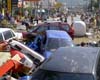
A global relief effort was underway Monday after the world's worst earthquake in 40 years triggered monstrous tidal waves which killed more than 14,000 people across southern and southeast Asia. |
|
| The content herein, unless otherwise known to be public domain, are Copyright 1995-2006 - SpaceDaily.AFP and UPI Wire Stories are copyright Agence France-Presse and United Press International. ESA PortalReports are copyright European Space Agency. All NASA sourced material is public domain. Additionalcopyrights may apply in whole or part to other bona fide parties. Advertising does not imply endorsement,agreement or approval of any opinions, statements or information provided by SpaceDaily on any Web page published or hosted by SpaceDaily. Privacy Statement |