| . |  |
. |
| . | |
. |
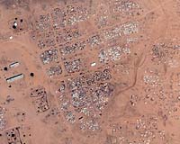
New York (AFP) Jun 06, 2007 Amnesty International said Wednesday it was using satellite technology to monitor the war-torn Sudanese region of Darfur in a bid to prevent future attacks on civilians. The watchdog's US chapter said it was the first time human rights monitors had used such technology to track possible targets of attack, prevent future atrocities and potentially save lives. Amnesty was inviting ordinary people worldwide to help protect 12 villages considered at risk of attacks by the government-backed Janjaweed militia by monitoring images on the project's website at www.eyesondarfur.org. Larry Cox, executive director of Amnesty USA, said the group wanted to send a message to Sudanese President Omar al-Beshir that the world was watching, and urged Beshir to accept a UN-mandated African Union peacekeeping force. "Darfur needs peacekeepers to stop the killing. In the meantime, we are taking advantage of satellite technology to tell president al-Bashir that we will be watching closely to expose any new violations," Cox said. "Our goal is to continue to put pressure on Sudan to allow the peacekeepers to deploy and to make a difference in the lives of vulnerable civilians on the ground in Darfur," he added in a statement. The four-year conflict in Darfur has left at least 200,000 people dead and forced more than two million people from their homes, according to the United Nations. Sudan disputes those estimates, saying 9,000 people have died. The Eyes on Darfur images come from commercial satellites and would allow activists to track developments as they occur, Amnesty said. While the images would not be live, they would only be a matter of a few days old. Lars Bromley, from the American Association for the Advancement of Science, which advised Amnesty on satellite imagery, said the images could show destroyed huts, massing soldiers or fleeing refugees. The group said the project would allow researchers to alert humanitarian officials on the ground if they spotted soldiers massing in an area. "The technology allows Amnesty International to expand its traditional role of shining a light on human rights violations," said Ariela Blatter, director of the Crisis Prevention and Response Center at Amnesty USA. Images of violations could also be used in any future prosecutions, she added.
Source: Agence France-Presse Email This Article
Related Links
 Robinson Island, Kenya (AFP) June 05, 2007
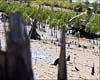
Standing in a muddy expanse of gnarled remains of dead mangroves, Guddy Birkigt sighed, explaining that her long fight to replant the watery forest was far from over. "I came here as a tourist before it was destroyed and there were mangroves everywhere. Then, when I came a few years later, I couldn't believe what I saw," said Birkigt, staring across the bleak landscape just a few hundred metres (yards) from the pristine white beaches and coconut trees of nearby Robinson Island, off Kenya's northeastern coast. |
|
| The content herein, unless otherwise known to be public domain, are Copyright 1995-2006 - SpaceDaily.AFP and UPI Wire Stories are copyright Agence France-Presse and United Press International. ESA PortalReports are copyright European Space Agency. All NASA sourced material is public domain. Additionalcopyrights may apply in whole or part to other bona fide parties. Advertising does not imply endorsement,agreement or approval of any opinions, statements or information provided by SpaceDaily on any Web page published or hosted by SpaceDaily. Privacy Statement |