| . |  |
. |
| . | |
. |
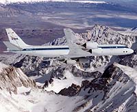
Fairbanks AK (SPX) Sep 22, 2004 Seven active Alaskan volcanoes are being studied in an airborne campaign this week by NASA and university scientists to gather data to evaluate volcanic hazards. In addition to volcanoes, instruments on board NASA's DC-8 flying laboratory are studying the Hubbard Glacier, Alaskan forests and sea ice. An Airborne Synthetic Aperture Radar (AirSAR) developed by NASA's Jet Propulsion Laboratory, Pasadena, Calif., is capturing 3-D images of the volcanoes, several of which are on the yellow level of concern. According to the Alaska Volcano Observatory, yellow means that an explosive eruption is possible within the next few weeks and may occur with little or no warning. AirSAR is an all-weather, side-looking imaging radar that, unlike typical radar, is able to penetrate forest canopies, dry snow pack and clouds. The instrument was built by JPL specifically for NASA's DC-8 airborne science laboratory, and is being used in Alaska in a variety of investigations that combine satellite and suborbital data to study the impact of climate variability on volcanoes, boreal forests, glaciers and floating sea ice. Digital elevation models taken by the sensor will allow scientists from the University of Alaska at Fairbanks to evaluate landscape changes and assess volcanic hazards. The scientists also hope to differentiate old from recent lava flows on the lower flanks of the mountains. Snow and ice cover on volcanoes is being investigated for changes relating to volcanic, climatic or other activity. "The volcanoes � Veniaminof, Shishaldin, Westdahl, Cleveland, Carlisle, Herbert and Spurr � are among the 100 active volcanoes at the higher latitudes in the North Pacific Region," said Ken Dean, research associate professor of the Geophysical Institute, University of Alaska at Fairbanks. "These volcanoes have the potential of injecting ash into the troposphere and stratosphere which is of concern to commercial and military aircraft. Studying subtle volcanic changes may eventually improve the ability to alert the public, government agencies and industry of potential ash eruptions." Unlike most glaciers in Alaska, Hubbard Glacier has been advancing since it was first mapped in 1898. In 1986 the glacier created an ice dam at Gilbert Point, blocking the entrance to Russell Fjord until it burst that October. An ice dam was again created and burst in 2002. Hubbard Glacier may continue to advance and repeatedly create dams until the ice dam at Gilbert Point becomes semi-permanent or permanent. This would redirect drainage out of the Situk River, impacting the residents of the nearby community of Yakutat. AirSAR is acquiring data that will be used to derive an accurate digital elevation model of the glacier, enabling scientists to assess the mass of the glacier. The DC-8 laboratory is also flying over a series of forest study sites from the Kenai Peninsula to Northern Alaska's Brooks Range. Scientists have been gathering biophysical information from these sites during the past few years and will use information from AirSAR to compare study sites with vegetation in the surrounding areas. JPL scientists are using AirSAR to image floating sea ice in the Arctic Ocean. The new data captured during this study, using the broad range of AirSAR measurement capabilities, will be compared to similar data taken during 1988 to assess possible physical changes in the recent climate patterns. NASA's QuikSCAT and AMSR-E, the European Remote Sensing satellite and the Canadian RADARSAT are continuously collecting data to support these studies. Another instrument on the NASA aircraft is the Research Environment for Vehicle-Embedded Analysis on Linux (REVEAL). NASA's future Earth Observation System of sensors and vehicles will include an increasing amount of autonomy, meaning neither a pilot nor sensor operator will be on the aircraft. The prototype REVEAL system is being tested as a means to connect instrument platforms with other instruments and ground-based operators via routine network access. "REVEAL is helping enable sensor networks for Earth science applications," said Larry Freudinger, REVEAL project lead at the NASA Dryden Flight Research Center, Edwards, Calif. "This system is taking part in the AirSAR mission to gain experience prior to being implemented on high-altitude, uninhabited aircraft." The DC-8 flying laboratory, based at NASA Dryden, is conducting the Alaskan survey flights from Elmendorf Air Force Base near Anchorage. The Alaska study is funded by NASA's Science Mission Directorate, which is dedicated to understanding the Earth as an integrated system and applying Earth System Science to improve prediction of climate, weather and natural hazards. Related Links NASA's AirSAR mission SpaceDaily Search SpaceDaily Subscribe To SpaceDaily Express
 St Louis MO (SPX) Sep 22, 2004
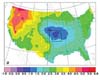
In the future, global warming might not be as severe in the central United States as in other parts of the country, according to scientists at Saint Louis University and Iowa State University (ISU). |
|
| The content herein, unless otherwise known to be public domain, are Copyright 1995-2006 - SpaceDaily.AFP and UPI Wire Stories are copyright Agence France-Presse and United Press International. ESA PortalReports are copyright European Space Agency. All NASA sourced material is public domain. Additionalcopyrights may apply in whole or part to other bona fide parties. Advertising does not imply endorsement,agreement or approval of any opinions, statements or information provided by SpaceDaily on any Web page published or hosted by SpaceDaily. Privacy Statement |