| . |  |
. |
Boston - Nov 19, 2003 Back in the old days, when doctors looked for tumors, exploratory surgery was the only option. Today they use CAT scans, x-rays, ultrasound, and other non-intrusive methods for checking out what lies beneath the skin's surface. But how do we determine what is beneath the Earth's surface? Invasive surgery on the Earth is just as dated as doctors' old methods of finding tumors, if you ask Eric Miller, associate professor of electrical and computer engineering at Northeastern University. If we humans can rely on CAT scans to form three-dimensional computer models of our insides, surely "CAT scans for the Earth" can be valuable in finding contaminants such as nuclear waste, to replace drilling and other harmful methods. Miller and his team, with funding from the Department of Energy, are busily toiling away on this very kind of environmental remediation and monitoring. For much of the last half of the last century, waste was disposed of in less-than-careful ways. This waste was generated from the buildup of the country's nuclear stockpile. In many locations, there's a question about just what is in the earth and how it's moving � a question that can be answered by digging up large tracks of land. But Miller says that not only is digging not economically feasible, it can also be dangerous if contaminants are exposed and not treated properly. "One of the legacies of the Cold War is the proliferation of buried chemical and radioactive waste on the grounds of many Department of Energy labs," says Miller. "While people know roughly where material is buried, it is often the case that detailed records are not available. Working with the DOE National Lab in Idaho, we have been exploring processing methods designed to develop a �map' of the subsurface which is required before excavation can begin." CAT scans of the Earth involve imaging of the planet's internal structure, which is useful for two reasons. First, the images can be used to "see" where the contaminants are, how they are moving, and how successful the treatment of the contaminants is. Second, images can help determine the details of the sedimentary structure of the Earth in regions where contaminants are located. Imaging can then be used to develop maps so we can see or predict where the contaminants may flow in the future. With medical imaging, doctors are free to place the patient in a machine that collects data from all around him or her, but with the Earth, experts are constrained in terms of where data can be collect data from: the surface and boreholes. This means that the data makes high quality image formation much more difficult. Miller and his team are developing new methods to improve the resolution of the resulting images. The work is conducted in close collaboration with geophysicists and hydrologists from the Department of Energy, who can use Miller's information to analyze the "fate and transport" of the contaminants flowing through the earth. Related Links Northeastern University SpaceDaily Search SpaceDaily Subscribe To SpaceDaily Express
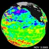 Pasadena - Nov 19, 2003
 Some climate forecast models indicate there is an above average chance that there could be a weak to borderline El Ni�o by the end of November 2003. However, the trade winds, blowing from east to west across the equatorial Pacific Ocean, remain strong. |
|
| The content herein, unless otherwise known to be public domain, are Copyright 1995-2006 - SpaceDaily.AFP and UPI Wire Stories are copyright Agence France-Presse and United Press International. ESA PortalReports are copyright European Space Agency. All NASA sourced material is public domain. Additionalcopyrights may apply in whole or part to other bona fide parties. Advertising does not imply endorsement,agreement or approval of any opinions, statements or information provided by SpaceDaily on any Web page published or hosted by SpaceDaily. Privacy Statement |