| . |  |
. |
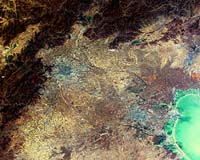
Lijiang, China (SPX) Jul 12, 2006 Nearly 200 scientists have gathered in this city in the Yunnan Province this week for the third annual Dragon Symposium. Opening the symposium, Liao Xiaohan, China's vice director of the Department of High Technology and Industrialization in the Ministry of Science and Technology, highlighted the success of the Dragon Program and the scientific results achieved so far, after two years of cooperation with ESA and MOST. The Dragon Program is a wide-ranging research initiative designed to encourage increased exploitation of ESA's Earth observation satellite data within China. In his address, ESA's Stephen Briggs, head of the Department of EO Science, Applications and Future Technologies, also welcomed the success of the Dragon Program and spoke of the progress in EO at ESA since last year's symposium in Greece. This year's event brings together the joint Sino-European teams assigned to work together after more than two years of activity to report on the progress and results of each project to date. Presentations will include details of research being done into the use of ESA's Envisat and ERS satellite sensors for the building up of land, ocean and atmosphere observations for thematic mapping of key environmental phenomena in China. Supporting in-situ data measurements required to validate the satellite results will be detailed and reports will be presented on joint field missions undertaken by the project teams in 2005. There currently are 16 Dragon projects including agricultural and forest monitoring, water resource assessment, atmospheric chemistry, terrain measurement, desertification, the ocean environment and climate change. The joint Sino-European teams are led by Chinese and European lead investigators. Since September 2004, 13 of the projects are supported by young European scientists who are receiving training in land, ocean and atmospheric applications in China. Presentations are set to include details of research being done into the synergistic use of Advanced Synthetic Aperture Radar with Envisat's optical Medium Resolution Imaging Spectrometer and other satellite sensors for the building up of land use databases for flood disaster assessment. Presenters will report on how using ASAR in multi-polarization mode improves the definition and mapping of flood extents, and the measuring of soil moisture content in the upper surface layer. Forests, which cover one seventh of China's land, have undergone dramatic changes in the last several decades due to forest fires, massive logging and insect infestation. The need to monitor the forests is increasing, especially since the introduction of new laws against deforestation. The Forest Dragon project was developed to generate forest and biomass maps for the main forested regions of China. To date, the generation of a wall-to-wall forest biomass map of Northeast China has been created based on multi-temporal ERS-1 and -2 tandem data and recently acquired Envisat Advanced Synthetic Aperture Radar data. The data can enable more accurate woodland monitoring using SAR Interferometry - or InSAR for short. InSAR involves combining two or more radar images of the same spot in such a way that very precise measurements can be made of ground motion taking place between acquisitions. When repeat pass acquisitions are combined in this way, forested areas can become de-coherent, providing a distinctive signature that enables forested areas to be classified from non-forested areas. China's spectacular economic growth during the last decade has brought many benefits along with some challenges. Global atmospheric mapping of nitrogen dioxide pollution performed by ERS-2's Global Monitoring Ozone Experiment instrument and Envisat's Scanning Imaging Absorption Spectrometer for Atmospheric Chartography instrument revealed a high level of NO2 hanging above Beijing and northeast China. Also as part of the Dragon Program, Chinese and European researchers are using results returned from GOME and SCIAMACHY to monitor Chinese air quality. Forecasting of air pollution is important to warn and inform the general public. By using data assimilation in combination with meteorological data, researchers are able to forecast air pollution levels. Flooding is the world's most costly type of natural disaster. In China, flooding has cost billions of Euros, caused many fatalities and displaced millions of people. The flooding that occurred in 2005 of the Xijiang, Hanjiang and Weihe Rivers killed 1,247 people, left 331 missing and caused 14 billion Euros worth of damage. One of the biggest problems is obtaining a clear picture of the overall extent of the flood. Wide area satellite images can show an entire flood within a single picture, with radar instruments of the type flown on ESA's ERS and Envisat spacecraft especially well suited for differentiating between flooded and dry land. A sequence of satellite images can show if the flood is growing or diminishing over time and highlight further areas coming under threat of inundation. Within the Dragon Program, a short notice acquisition and delivery procedure exists, enabling Chinese partners to request ASAR acquisitions ahead of the satellite overpass. The processed images are available to download from ESA servers within eight hours after acquisition. By comparing before and after images of the flooded region, a rapid and authoritative damage assessment estimate can be made, factoring in different land cover types to quantify the cost of the flood. Chinese authorities are able to use the maps to identify floodwater extent and coordinate mitigation efforts. Related Links Dragon Symposium
 Melbourne, Australia (SPX) Jul 12, 2006
Recently, the media has experienced another cascade of reports on the possibility of a Chinese manned lunar program. Translations of an article from a Hong Kong newspaper have hit the wires, and even found their way back into English-language versions of mainland Chinese publications. |
|
| The content herein, unless otherwise known to be public domain, are Copyright 1995-2006 - SpaceDaily.AFP and UPI Wire Stories are copyright Agence France-Presse and United Press International. ESA PortalReports are copyright European Space Agency. All NASA sourced material is public domain. Additionalcopyrights may apply in whole or part to other bona fide parties. Advertising does not imply endorsement,agreement or approval of any opinions, statements or information provided by SpaceDaily on any Web page published or hosted by SpaceDaily. Privacy Statement |