| . |  |
. |
| . | |
. |
|
by Staff Writers Greenbelt MD (SPX) Mar 14, 2016
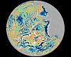
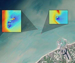
An estimated 3 million shipwrecks are scattered across the planet's oceans. Most maritime mishaps take place close to shore where hazards to navigation - such as rocks, reefs, other submerged objects and vessel congestion - are abundant. While there is a romantic association of shipwrecks and buried treasure, it is desirable to know where they are located for many other practical reasons. The ships may be of historical significance or, if the hard substrate of the ship has created a reef, of ecological significance. Modern-era shipwrecks are also commonly sources of pollution, leaking onboard fuel and corroded heavy metals. Nearshore shipwrecks can be navigational hazards themselves. Researchers have found that shipwrecks near the coast can leave sediment plumes at the sea's surface that help reveal their location. Using data from the NASA/USGS Landsat 8 satellite, researchers have detected plumes extending as far as 4 kilometers (about 2.5 miles) downstream from shallow shipwreck sites. This discovery demonstrates for the first time how Landsat and Landsat-like satellites may be used to locate the watery graves of coastal shipwrecks. A quarter of all shipwrecks may rest in the North Atlantic. In the narrow southern end of the North Sea, where the English coast is only 100 miles from the shores of Belgium and the Netherlands, World War II-era shipwrecks are plentiful. In this area, mines, submarines, other submersibles and warships targeted cargo ships sailing between Allied countries and Dutch and Belgian ports. The potential negative environmental impacts of these modern-era shipwrecks are substantial enough that the Council of Europe's Parliamentary Assembly has recommended they be mapped and monitored. While airborne lidar (which uses light pulses to measure distance) can be used to detect shipwrecks close to shore and multibeam echosounders and other sound-based methods can be used anywhere deep enough for a survey vessel to sail, the former method requires clear water and cost prohibits both methods from being used to conduct exhaustive coastal surveys. A new study published in the Journal of Archaeological Science by authors Matthias Baeye and Michael Fettweis, from the Royal Belgian Institute of Natural Sciences; Rory Quinn from Ulster University in Northern Ireland; and Samuel Deleu from Flemish Hydrography, Agency for Maritime and Coastal Services, aims to change things. The authors have found a way to use freely available Landsat satellite data to detect shipwrecks in sediment-laden coastal waters. Their study, conducted in a coastal area off of the Belgium port of Zeebrugge, relied on a detailed multibeam echosounder survey of wreck sites, previously conducted by the Flemish government. This part of the Belgian coast is strewn with shipwrecks, in often sediment-laden waters. The researchers started with the known location of four fully submerged shipwrecks in their study site: the SS Sansip, which the authors explain was a 135 m (443 foot) U.S. Liberty ship that sank after striking a mine in December 1944; the SS Samvurn, a similar ship that met the same fate the very next month; as well as the SS Nippon, a ship that sank after a maritime collision in 1938; and the SS Neutron, a small 51 m (167 foot) steel cargo vessel that fell victim to an uncharted navigation hazard, presumed to be the SS Sansip. Using 21 Landsat 8 images and tidal models, the researchers mapped sediment plumes extending from the wreck locations. They found that the two ships with substantial portions of their structure unburied created sediment plumes that could be traced downstream during ebb and flood tides. The authors postulate that the exposed structure of these ships created scour pits that then fill with fine sediments (sand, clay, organic matter, etc.) during slack tides (the period of relatively still currents between ebb and flood tides). These scour pits then serve as sediment repositories from which sediments are re-suspended during flood and ebb tides. When these sediments reach the surface, they create their telltale plumes. Uncharted shipwrecks could be located by using the researchers' methodology in reverse - i.e., mapping sediment plumes during various tidal stages and then following the plumes upstream to their point of origin. The study looked at shipwrecks in waters as deep as 15 m (50 feet); depth is an essential consideration as the re-suspended sediment plumes must reach the surface to be detected by optical satellites like Landsat. Given that coastal waters are typically shallow, often sediment-laden, and where most shipwrecks occur, this new shipwreck detection method could prove useful for marine archaeologists. The Landsat Program is a series of Earth observing satellite missions jointly managed by NASA and the U.S. Geological Survey. Landsat satellites have been consistently gathering data about our planet since 1972. Landsat 8, designed with many evolutionary advances, launched in 2013.
Related Links Goddard Space Flight Center Earth Observation News - Suppiliers, Technology and Application
|
|||||||||||||
| The content herein, unless otherwise known to be public domain, are Copyright 1995-2026 - SpaceDaily. All websites are published in Australia and are solely subject to Australian law and governed by Fair Use principals for news reporting and research purposes. By using our websites you consent to cookie based advertising. If you do not agree with this then you must stop using the websites from May 25, 2018. Privacy Statement. Additional information can be found here at About Us. |
 del.icio.us
 Digg
Digg Reddit
 Google