| . |  |
. |
Paris (ESA) Nov 12, 2002 Writing in last week's issue of Nature magazine, a team of European and Indonesian scientists detail their use of ESA and NASA satellite imagery to help measure huge amounts of carbon dioxide released into the atmosphere by 1997-98 fires in the tropical bush of Indonesia. A series of peatland and forest fires blamed on the El Nino climate phenomena devastated huge tracts of rainforest in Southeast Asia, hitting Indonesia particularly hard, in the most widespread fires in the region. The El Nino reduced precipitation and extended drought conditions throughout Southeast Asia and the Pacific region. The resulting fires produced a noxious yellow haze that covered an area 3000 by 5000 kilometres for months. Estimates of the economic damage to Indonesia, and neighbouring countries of Singapore, Malaysia, Brunei and Thailand, totalled more than $2 billion (Euro 2.006 billion). For the study, the researchers focused on tropical peat swamp forests, a largely overlooked ecosystem with peat deposits up to 20 metres deep. Because of the high carbon content of this organic soil, surface fires spread underground into the peat layer, not burning completely and producing huge amounts of smoke and fine particles. The peat swamp forests represent approximately 40 percent of the total area burned in Indonesia during the 1997-98 El Nino.
Fires unleash huge amounts of carbon dioxide The study highlights that tropical peat stores huge amounts of carbon that will continue to be released to the atmosphere as carbon dioxide during future forest fires and land conversion from forest to agriculture. Carbon dioxide, one of the so-called "greenhouse gases," is responsible for global warming of the Earth's atmosphere. Recurrent fires have the threatening potential of making a very significant contribution to this warming, particularly during an El Nino. "The data presented in Nature are as relevant as ever because the forests in Indonesia have again been burning during this year's extended dry season, caused by a weak El Nino weather event," commented Dr. Florian Siegert, managing director of Remote Sensing Solutions (RSS) GmbH, a Munich-based consultancy and applications developer of Earth observation solutions. "Unfortunately the world does not pay attention to that."
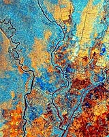
ERS-2 radar imagery sees through the smoke To analyse the same region after the fires, however, optical satellite systems were at a disadvantage because of the residual haze and frequent cloud cover. To solve the problem, the team turned to ESA and imagery from the ERS-2 spacecraft and its synthetic aperture radar (SAR). Radar-based sensors such as the SAR onboard ERS-2 are ideal for penetrating clouds and haze. The advanced SAR carried on ESA's Envisat satellite will continue to monitor the drought and other effects of El Nino. "ERS-2 radar satellite imagery was required to identify burnt areas not detectable in Landsat," Siegert said. The ERS-2 radar imagery not only saved the team valuable time, but also was able to capture information about the study area that would not wait for better viewing conditions. "The first cloud-free Landsat image available from this area was acquired half a year later and some burnt areas could not be detected anymore due to fast regrowth of vegetation," Siegert said.
Combination of drought and poor development can be catastrophic "The combination of drought with wrong development programs and wrong land use policy lead into the catastrophe," Siegert said. "Overexploitation by selective logging and drainage of the peat swamps makes this ecosystem susceptible to fire." Unless land use policies are not changed to control logging and to introduce reduced impact logging techniques, recurrent fires will lead to a complete loss of Borneo's peat swamp forests and continued, high emissions of carbon dioxide to the atmosphere. The study's scientists are demanding intensive national and international efforts to avoid further fires in the tropical peat swamp forests. Related Links Nature RSS ERS 1 and 2 ERS Instruments Envisat Envisat results SpaceDaily Search SpaceDaily Subscribe To SpaceDaily Express
 Washington - Nov 12, 2002
The world's largest general scientific organization -- the American Association for the Advancement of Science (AAAS) -- today urged policymakers to oppose teaching "Intelligent Design Theory" within science classrooms, but rather, to keep it separate, in the same way that creationism and other religious teachings are currently handled. |
|
| The content herein, unless otherwise known to be public domain, are Copyright 1995-2006 - SpaceDaily.AFP and UPI Wire Stories are copyright Agence France-Presse and United Press International. ESA PortalReports are copyright European Space Agency. All NASA sourced material is public domain. Additionalcopyrights may apply in whole or part to other bona fide parties. Advertising does not imply endorsement,agreement or approval of any opinions, statements or information provided by SpaceDaily on any Web page published or hosted by SpaceDaily. Privacy Statement |