|
|
| . |  |
. |
|
|
by Staff Writers Pasadena CA (JPL) Sep 02, 2014
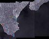
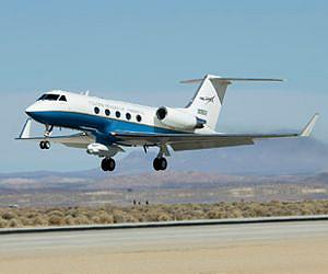
NASA scientists are planning to conduct an airborne survey of earthquake fault displacements in the Napa Valley area of Northern California, using a sophisticated radar system developed by NASA's Jet propulsion Laboratory (JPL) in Pasadena, California. Pending results of a Thursday afternoon instrument checkout flight, a modified C-20A aircraft from NASA's Armstrong Flight Research Center carrying JPL's Uninhabited Aerial Vehicle Synthetic Aperture Radar (UAVSAR) was scheduled to fly a five-hour data-collection mission on Friday, Aug. 29 over the area that experienced a major quake during the pre-dawn hours on Sunday, Aug. 24. The 6.0-magnitude quake, centered near Napa, was the strongest to occur in the San Francisco Bay Area in a quarter-century. It caused extensive damage and numerous injuries in Napa and nearby areas, although no deaths were reported. Data from the flight will be compared with data acquired by the UAVSAR on previous missions over the same area to determine if significant displacements have occurred along fault lines. The radar can measure tiny movements of the ground of less than half an inch, or less than a centimeter, from an altitude of almost eight miles above ground. According to Randal Albertson, deputy director of NASA's Airborne Science Program at NASA Armstrong, the mission will enable JPL scientists to acquire new data "to build on the data sets we already have to help us better understand the mosaic of Northern California faults, possible impacts of the drought and lower ground water, as well as the impact the earthquake had on the critical levee system" in the California delta east of the San Francisco Bay Area. "What we are doing has real potential science benefit to Californians and the nation," he added. JPL UAVSAR project manager Yunling Lou said obtaining new data shortly after the recent quake rather than waiting until later would have several benefits, among them: + Early acquisition would enable scientists to distinguish between co-seismic and post-seismic deformation events. This means improved information on fault mechanics, better predictions of where aftershocks might occur and a better estimate of earthquake hazard. + Results would be shared with agencies such as the California Earthquake Clearinghouse to support damage assessment efforts. The deformation is very subtle, so UAVSAR data can offer a critical contribution in terms of quantifying fault offsets. + Two data lines will cover the North Bay Aqueduct. The California Department of Water Resources is still assessing the damage there and needs to know how much movement occurred in soft soil areas near the delta. The UAVSAR radar survey missions are flown at an altitude of about 41,000 feet. The comparison of data recorded during previous flights with new data is aided greatly by a Precision Platform Autopilot developed by NASA Armstrong engineers that enables the C-20A to fly its data collection flight tracks within about 30 feet of those previously flown.
Related Links NASA JPL UAVSAR instrument Earth Observation News - Suppiliers, Technology and Application
|
|
| The content herein, unless otherwise known to be public domain, are Copyright 1995-2014 - Space Media Network. All websites are published in Australia and are solely subject to Australian law and governed by Fair Use principals for news reporting and research purposes. AFP, UPI and IANS news wire stories are copyright Agence France-Presse, United Press International and Indo-Asia News Service. ESA news reports are copyright European Space Agency. All NASA sourced material is public domain. Additional copyrights may apply in whole or part to other bona fide parties. Advertising does not imply endorsement, agreement or approval of any opinions, statements or information provided by Space Media Network on any Web page published or hosted by Space Media Network. Privacy Statement All images and articles appearing on Space Media Network have been edited or digitally altered in some way. Any requests to remove copyright material will be acted upon in a timely and appropriate manner. Any attempt to extort money from Space Media Network will be ignored and reported to Australian Law Enforcement Agencies as a potential case of financial fraud involving the use of a telephonic carriage device or postal service. |
 del.icio.us
 Digg
Digg Reddit
 Google