| . |  |
. |
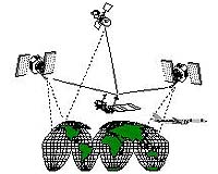
Washington - Oct 15, 2002 NASA researchers have demonstrated the ability to very precisely navigate airplanes in real time, anywhere in the world, independent of local navigational aids or infrastructure. The breakthrough will not only benefit scientists, but promises to extend precision navigation to infrastructure-poor areas of the world, potentially enhancing aviation safety in these areas. Ron Muellerschoen, lead architect of the NASA Global Differential GPS system at NASA's Jet Propulsion Laboratory, Pasadena, Calif., has demonstrated the ability of the system to achieve real-time aircraft positioning accuracy of 10 centimeters (3.9 inches) horizontally and 20 centimeters (7.9 inches) vertically, anywhere in the world� a factor of 10 improvement over current autonomous navigation systems. The system relays precise, real-time navigation data to specially equipped aircraft. The JPL team's results were presented recently at the Institute of Navigation Global Positioning System (GPS) 2002 Exhibit in Portland, Ore. Although developed to improve the accuracy, efficiency and timeliness of Earth science missions, the technology's by-products may also include numerous civil and commercial applications in such areas as aviation safety, marine operations, land management, transportation and agriculture, said Dr. Yoaz Bar-Sever, the principal investigator for NASA's Global Differential GPS system at JPL. "Civil and commercial navigation services, currently only available within Earth's infrastructure-rich regions, could now be extended to any part of the world without lowering performance and with little to no marginal cost," he said. Within the field of Earth science, Bar-Sever said the technology would be used to develop better exploration techniques for Earth observing instruments flying aboard aircraft and spacecraft. "The ability of Earth science instruments to precisely and autonomously know their position and velocity in real time is critical to many Earth observing applications, including monitoring and responding to natural hazards such as earthquakes, volcanoes and hurricanes," he said. JPL's Airborne Synthetic Aperture Radar Group has already used the precise real positioning from the Global Differential GPS system to improve the resolution of Earth images from NASA's aircraft-based Airborne Synthetic Aperture Radar instrument, said Group Supervisor David Imel. Imel envisions even greater use for the system in the near future. "For missions where an aircraft must fly exactly the same flight profile repeatedly, in order to sense subtle changes in the Earth from one flight to the next, the need for the extremely precise navigational accuracy that this system provides is critical," he said. In space, precise onboard knowledge of position will improve the efficiency of a spacecraft's onboard data processing and reduce the time needed to transmit data to the ground. Bar-Sever and his team have already conducted successful demonstrations of decimeter-level real-time satellite positioning using data from NASA's Jason-1 spacecraft and the Argentinean Satelite de Aplicaciones Cientificas-C satellite. The team is currently developing a prototype payload to be flown aboard a spacecraft. The NASA Global Differential GPS system flight demonstrations were conducted over the United States and Greenland in February through September 2002 aboard a NASA Airborne Synthetic Aperture Radar DC-8 aircraft from NASA's Hugh L. Dryden Flight Research Center, Edwards, Calif., and a NASA P-3 aircraft from NASA's Wallops Flight Facility, Wallops Island, Va. Developed and operated by JPL since 1999 for NASA's terrestrial, airborne, and spaceborne science applications, NASA's Global Differential GPS system provides end-to-end capabilities for autonomous, real-time orbit determination and positioning at unprecedented levels of accuracy and availability. The system processes real-time GPS data from a global network of more than 30 dual-frequency GPS ground sites. It is the only system in existence that provides global, multiply redundant, real-time coverage of all GPS satellites, all the time. It routinely and automatically produces the most accurate real-time estimates of GPS satellite orbits and clocks, media calibrations and many other products and performance metrics. The system leverages NASA investments in the global GPS network and the U.S. Government's investment in the Wide Area Augmentation System navigation technology developed at JPL. Related Links Internet-based Global Differential GPS System SpaceDaily Search SpaceDaily Subscribe To SpaceDaily Express
 Paris (ESA) Sep 19, 2002
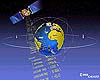
Galileo, Europe's billion-euro satellite navigation system, will provide a guaranteed service when it becomes fully operational in about 2008. However, radio signals broadcast by other users in the Galileo frequency band could interfere with reception in some areas. This summer the European Space Agency has been investigating where the interference is and what to do about it. |
|
| The content herein, unless otherwise known to be public domain, are Copyright 1995-2006 - SpaceDaily.AFP and UPI Wire Stories are copyright Agence France-Presse and United Press International. ESA PortalReports are copyright European Space Agency. All NASA sourced material is public domain. Additionalcopyrights may apply in whole or part to other bona fide parties. Advertising does not imply endorsement,agreement or approval of any opinions, statements or information provided by SpaceDaily on any Web page published or hosted by SpaceDaily. Privacy Statement |