|
|
| . |  |
. |
|
|
by Staff Writers Pasadena CA (JPL) Apr 04, 2014
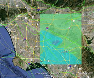
On March 28, residents of Greater Los Angeles experienced the largest earthquake to strike the region since 2008. The magnitude 5.1 quake was centered near La Habra in northwestern Orange County about 21 miles (33 kilometers) east-southeast of Los Angeles, and was widely felt throughout Southern California. There have been hundreds of aftershocks, including one of magnitude 4.1. Scientists at NASA's Jet Propulsion Laboratory, Pasadena, Calif., have developed a model of the earthquake, based on the distribution of aftershocks and other seismic information from the U.S. Geological Survey. A new image based on the model shows what the earthquake may look like through the eyes of an interferometric synthetic aperture radar, such as NASA's Uninhabited Aerial Vehicle Synthetic Aperture Radar (UAVSAR). JPL scientists plan to acquire UAVSAR data from the region of the March 28 quake, possibly as soon as this week, and process the data to validate and improve the results of their model. The model image is online here. The earthquake is believed to be associated with the Puente Hills Thrust fault, a blind thrust fault (meaning it does not break the earth surface) that zigzags from Orange County northwest through downtown Los Angeles. The same fault was responsible for the magnitude 5.9 Whittier Narrows earthquake on Oct. 1, 1987, which caused eight fatalities, injured several hundred and left about $360 million in property damage. The NASA model is based on a fault estimated to be 5.6 miles (9 kilometers) long, 3.1 miles (5 kilometers) deep and 1.9 miles (3 kilometers) wide. The modeled fault segment dips upward through the ground at a 60-degree angle. The model estimated that in this earthquake, one side of the fault moved at a slanted angle horizontally and vertically 3.9 inches (10 centimeters) relative to the other side. The model also estimated the maximum displacement of Earth's surface from the quake at approximately 0.4 inch (1 centimeter), which is at the threshold of what is detectable with UAVSAR. The region of greatest ground displacement is indicated by the darker blue area located in the right center of the image. In Nov. 2008, NASA JPL scientists began conducting a series of UAVSAR flights over regions of Northern and Southern California that are actively deforming and are marked by frequent earthquakes. About every six months, the scientists precisely repeat the same flight paths to produce images of ground deformation called interferograms. From these data, 3-D maps are being created for regions of interest, including the San Andreas and other California faults, extending from the Gulf of California in Mexico to Santa Rosa in the northern San Francisco Bay. UAVSAR, which flies on a NASA C-20A aircraft from NASA's Armstrong Flight Research Center in California, measures ground deformation over large areas to a precision of 0.04 to 0.2 inches (0.1 to 0.5 centimeters). By comparing the repeat-pass radar observations, scientists hope to measure any crustal deformations that may occur between observations, allowing them to "see" the amount of strain building up on fault lines, and giving them a clearer picture of which faults are active and at what rates they're moving, both before earthquakes and after them. The UAVSAR fault mapping project is designed to substantially improve knowledge of regional earthquake hazards in California. The 3-D UAVSAR data will allow scientists to bring entire faults into focus, allowing them to understand faults not just at their surfaces, but also at depth. When integrated into computer models, the data should give scientists a much clearer picture of California's complex fault systems. The scientists are estimating the total displacement occurring in each region. As additional observations are collected, they expect to be able to determine how strain is partitioned between individual faults. The UAVSAR flights serve as a baseline for pre-earthquake activity. As earthquakes occur during the course of this project, the team is measuring the deformation at the time of the earthquakes to determine the distribution of slip on the faults, and then monitoring longer-term motions after the earthquakes to learn more about fault zone properties. Airborne UAVSAR mapping can allow a rapid response after an earthquake to determine what fault was the source and which parts of the fault slipped during the earthquake. Information about the earthquake source can be used to estimate what areas were most affected by an earthquake's shaking to guide rescue efforts and damage assessment. The model was developed as part of NASA's QuakeSim project. The JPL-developed QuakeSim is a comprehensive, state-of-the-art software tool for simulating and understanding earthquake fault processes and improving earthquake forecasting. Initiated in 2002, QuakeSim uses NASA remote sensing and other earthquake-related data to simulate and model the behavior of faults in 3-D both individually and as part of complex, interacting systems. This provides long-term histories of fault behavior that can be used for statistical evaluation. QuakeSim also is used to identify regions of increased earthquake probabilities, called hotspots. NASA's Earthquake Data Enhanced Cyber-Infrastructure for Disaster Evaluation and Response (E-DECIDER) project, which provides tools for earthquake disaster management and response using remote sensing data and NASA earthquake modeling software, published the model results, along with automatically generated deformation models and aftershock forecasts on a La Habra earthquake event page
Related Links QuakeSim UAVSAR at JPL Bringing Order To A World Of Disasters When the Earth Quakes A world of storm and tempest
|
|
| The content herein, unless otherwise known to be public domain, are Copyright 1995-2014 - Space Media Network. All websites are published in Australia and are solely subject to Australian law and governed by Fair Use principals for news reporting and research purposes. AFP, UPI and IANS news wire stories are copyright Agence France-Presse, United Press International and Indo-Asia News Service. ESA news reports are copyright European Space Agency. All NASA sourced material is public domain. Additional copyrights may apply in whole or part to other bona fide parties. Advertising does not imply endorsement, agreement or approval of any opinions, statements or information provided by Space Media Network on any Web page published or hosted by Space Media Network. Privacy Statement All images and articles appearing on Space Media Network have been edited or digitally altered in some way. Any requests to remove copyright material will be acted upon in a timely and appropriate manner. Any attempt to extort money from Space Media Network will be ignored and reported to Australian Law Enforcement Agencies as a potential case of financial fraud involving the use of a telephonic carriage device or postal service. |
 del.icio.us
 Digg
Digg Reddit
 Google