| . |  |
. |
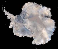
Moffett Field CA (SPX) May 15, 2006 NASA said Monday it has updated its World Wind computer program that enables Internet users not only to explore the Earth and the Moon, but also to fly, virtually, through Martian canyons and visit Venus and Jupiter in 3-D color. The new version also allows users to see some of Jupiter's moons and EVEN cruise into the depths of Earth's oceans. "The users - from the comfort of their own homes - can visit anyplace on Earth, Mars and other places in the solar system," said Chris Maxwell, lead World Wind developer at NASA's Ames Research Center. "All you need is (a) standard personal computer with a decent video card and a decent Internet connection." More than 10 million individuals have used World Wind since NASA first released it about a year ago. "Well over 100,000 new users download the program each week from all over the planet," said Patrick Hogan, World Wind's program manager. The program itself is only five megabytes, but data containing place names and imagery make up the rest of the 50-megabyte download, Hogan explained. A version written in the Java computer language, which will run on Macintosh and Linux computers, is scheduled for release next September, he noted. "NASA is providing the free World Wind program to improve public and researcher access to high-quality imagery and other data," Hogan said. In the future, the software will be updated to give users the chance to explore other planets when additional data sets become available. The software can transport Web users to just about anywhere on the Moon, using images taken by the Clementine spacecraft in the 1990s. Hogan said the resolution is about 66 feet (20 meters) per pixel. Launched in early 1994, Clementine captured 1.8 million images of the lunar surface during its two-month orbit of the Moon. The Ballistic Missile Defense Organization and NASA jointly sponsored the Deep Space Program Science Experiment that included Clementine. Its principal objective was to space-qualify lightweight imaging sensors and component technologies for the next generation of U.S. military spacecraft. World Wind also enables users to understand Earth's natural processes more completely, such as changing weather and ozone conditions, ocean temperature and earthquake activity. "We're working with the United States Geological Survey and the Department of Defense to deliver their data to the public," Hogan said, adding that the Defense Department is using World Wind, and the National Guard plans to make use of the software to help respond to natural disasters. NASA processes almost 10 million requests for World Wind imagery daily. The program is delivering terabytes of global NASA satellite resulting from years of daily observations of precipitation, temperature, barometric pressure and other atmospheric characteristics. Hurricane Katrina data are part of World Wind's collection of images. NASA programmers recently increased the resolution of images of Earth from 3,281 feet (one kilometer) per pixel to 1,640-feet (500 meters) in an upgrade called Blue Marble: Next Generation Earth. Some World Wind data sets include images of the entire planet at a resolution of 49 feet (15 meters) per pixel. World Wind accesses public domain USGS aerial photography and topographic maps, as well as shuttle radar topography mission and Landsat satellite data. NASA said computer users from more than 100 nations have acquired the free World Wind program, though most are in the United States. Related Links Nasa Worldwind Download
 Edinburgh, UK (SPX) May 16, 2006
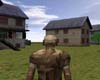
Plenoptics specialises in services and technology for the creation of highly realistic 3D models from 2D digital photography sources. Photo realistic and extremely accurate interior and exterior scenes can be created from photographic material either provided by the client or produced by Plenoptics own technical team. |
|
| The content herein, unless otherwise known to be public domain, are Copyright 1995-2006 - SpaceDaily.AFP and UPI Wire Stories are copyright Agence France-Presse and United Press International. ESA PortalReports are copyright European Space Agency. All NASA sourced material is public domain. Additionalcopyrights may apply in whole or part to other bona fide parties. Advertising does not imply endorsement,agreement or approval of any opinions, statements or information provided by SpaceDaily on any Web page published or hosted by SpaceDaily. Privacy Statement |