| . |  |
. |
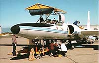
Tombstone AZ (SPX) Aug 09, 2004 Tombstone, Arizona, is a dusty place known for Wyatt Earp's famous 1881 "Gunfight at the O.K. Corral." This year, from August 2 to 27, it will be known as the place where scientists from NASA, the US Department of Agriculture (USDA), the National Oceanic and Atmospheric Administration (NOAA), and other institutions gather and study soil moisture to improve weather forecasts and the ability to interpret satellite data. NASA's ER-2 high-altitude aircraft is flying Soil Moisture Experiment 2004 (SMEX04) missions over Arizona from its base at the Dryden Flight Research Center, Edwards, Calif. The aircraft carries the Airborne Visible/Infrared Imaging Spectrometer that investigates methods for remotely sensing water content in plants. Also onboard is the Moderate Resolution Imaging Spectroradiometer Airborne Simulator. This instrument collects thermal infrared data on soil moisture content that complements the spectral-resolution of AVIRIS. ER-2 mission manager Jeannette van den Bosch said the ER-2's involvement in the experiment was due to the serendipitous availability of the aircraft between other scheduled science missions. SMEX04 is using ground teams, airplanes and NASA satellites and instruments to measure soil moisture in Tombstone, Ariz., and Sonora, Mexico, where water supplies are critical. By identifying how much moisture is retained in soils, hydrologists will be able to determine how much more water can be absorbed, and thus better estimate the potential for flooding or how much water sinks into the water table. During July and August, the U.S. southwestern monsoon season is characterized by a wind pattern shift that exerts a strong influence on precipitation and temperatures across the western United States, Mexico and adjacent ocean areas. This change in winds creates many rainy days and heavy rainfall, which are ideal conditions for studying soil moisture. Researchers from NASA, USDA, NOAA, Sonora Research Institute and more than a dozen universities will be on the ground and in the air with advanced technology to get a better read on soil moisture. SMEX scientists also want to know what atmospheric conditions create long-lasting rainfalls over a large area. By knowing which factors create large or small rainfall, hydrologists can provide better forecasts and know how much water will be available. "The western U.S. relies on water from the southwestern monsoon system to fill its aquifers. Accurate measurements of soil moisture will assist in better water supply forecasts associated with the monsoon in the water-scarce western U.S.," said Tom Jackson, USDA Agricultural Research Service hydrologist and lead for SMEX. From space, NASA's Aqua, Terra and QuikScat satellites provide various measurements. Aqua's Advanced Microwave Scanning Radiometer instrument measures soil moisture; Terra's Moderate Resolution Spectroradiometer provides vegetation status; and Terra's Advanced Spaceborne Thermal Emission and Reflection Radiometer measures the surface temperature. The SeaWinds instrument on the QuikScat satellite observes the monsoon winds that bring in the moisture from the Pacific Ocean to the U.S. Southwest. A Naval Research Laboratory P-3 aircraft that carries microwave radiometers is also participating. Meanwhile, ground instruments measure the temperature and percentage of moisture in soils from two to 40 inches deep. The satellite, airplane and ground data will be compared. The SMEX04 mission adds to two prior SMEX experiments in 2002 and 2003, and is part of the larger North American Monsoon Experiment, led by NOAA, which is dedicated to understanding how the southwestern U.S. monsoon season works. Monsoons need to be accurately understood and predicted by weather and climate models, because their influence on seasonal weather, including floods and droughts, can significantly disrupt regional economies and populations. Related Links SpaceDaily Search SpaceDaily Subscribe To SpaceDaily Express
 Denver CO (SPX) Aug 09, 2004
Space Imaging announced that imagery from India's RESOURCESAT-1 satellite is now available to the commercial marketplace. Space Imaging has the exclusive worldwide rights to sell data from RESOURCESAT-1 outside of India. |
|
| The content herein, unless otherwise known to be public domain, are Copyright 1995-2006 - SpaceDaily.AFP and UPI Wire Stories are copyright Agence France-Presse and United Press International. ESA PortalReports are copyright European Space Agency. All NASA sourced material is public domain. Additionalcopyrights may apply in whole or part to other bona fide parties. Advertising does not imply endorsement,agreement or approval of any opinions, statements or information provided by SpaceDaily on any Web page published or hosted by SpaceDaily. Privacy Statement |