| . |  |
. |
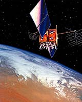
Cape Canaveral FL (SPX) Feb 10, 2005 Lockheed Martin has announced that it has delivered the first modernized Global Positioning System satellite to Cape Canaveral Air Force Station, Fla., where it will be readied for a May launch. The satellite, designated GPS IIR-M1, is the most technologically advanced GPS satellite ever developed and will provide significantly improved navigation performance for U. S. military and civilian users worldwide. The satellite is the first in a series of eight GPS IIR satellites that Lockheed Martin is modernizing for its customer at the Navstar GPS Joint Program Office, Space and Missile Systems Center, Los Angeles Air Force Base, Calif. "Delivery of the first modernized IIR satellite is a significant milestone in the GPS mission," said Dave Podlesney, Lockheed Martin GPS program director. "We will now shift our focus to preparations for launch, and achieving mission success for our customer, which will pave the way for greatly increased navigation capabilities for our military personnel as well as civil users worldwide." The current constellation of 30 GPS spacecraft includes 12 fully operational Block IIR satellites, which were developed to improve global coverage and increase the overall performance of the global positioning system. The modernized series, designated GPS IIR-M, will offer a variety of enhanced features for users of the navigation system, such as: - A modernized antenna panel that will provide increased signal power to GPS receivers on the ground. - Two new military signals that will allow for improved accuracy, enhanced encryption and anti-jamming performance for the military. - A second civil signal that will provide civil users with an open access signal on a different frequency. The flexible design of the modernized spacecraft will enable GPS users to experience these benefits after launch and operational turnover of the satellite. The Global Positioning System enables properly equipped users to determine precise time and velocity and worldwide latitude, longitude and altitude to within a few meters. Air Force Space Command's 2nd Space Operations Squadron (2SOPS), based at Schriever Air Force Base, Colo., manages and operates the GPS constellation for both civil and military users. The modernized navigation payload is being built by ITT Industries in Clifton, N.J. The satellite upgrades, along with final assembly, integration and test are being performed at Lockheed Martin facilities in Valley Forge, Pa. Related Links Lockheed Martin SpaceDaily Search SpaceDaily Subscribe To SpaceDaily Express
 St Paul MN (SPX) Feb 10, 2005
Digital Angel has announced that it plans to expand its OuterLink flight tracking system to more than 100 countries. Outerlink plans to use the Globalstar Satellite Network to expand the international coverage of its flight following and data messaging system as well as add voice capabilities. |
|
| The content herein, unless otherwise known to be public domain, are Copyright 1995-2006 - SpaceDaily.AFP and UPI Wire Stories are copyright Agence France-Presse and United Press International. ESA PortalReports are copyright European Space Agency. All NASA sourced material is public domain. Additionalcopyrights may apply in whole or part to other bona fide parties. Advertising does not imply endorsement,agreement or approval of any opinions, statements or information provided by SpaceDaily on any Web page published or hosted by SpaceDaily. Privacy Statement |