| . |  |
. |
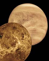
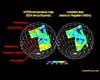
Paris, France (ESA) Dec 28, 2006 Scientists involved in a spectrometer experiment onboard the Venus Express mission of the European Space Agency ESA have succeeded in looking through the thick carbon dioxide atmosphere of Earth's sister planet. From the orbiting spacecraft they were able to obtain the first large-area temperature maps from the southern hemisphere of this unfriendly, lead-melting hot Venusian world. VIRTIS is the instrument that was used for obtaining these temperature measurements. "We are very much excited about these results about another important item in the list of the VIRTIS scientific objectives at Venus", says Giuseppe Piccioni, one of the Principal Investigators of the VIRTIS experiment, from the Istituto di Astrofisica Spaziale e Fisica Cosmica in Rome, Italy. The measurements reveal temperature variations of 30 degrees between lowlands and mountaintops, correlating well with existing topographical radar data from previous missions. "This is a major step forward in our attempt to identify specific surface features on the surface of Venus", states Jorn Helbert from the German Aerospace Center's (DLR) Institute of Planetary Research in Berlin, Germany, who is a member of the VIRTIS team. VIRTIS is a spectrometer that is able to peek through so-called "atmospheric windows" in the near-infrared wavelengths of the electromagnetic spectrum all the way to the surface of Venus. "We understand now good enough what we see in our data; this enables us to 'peel' off the atmospheric layers from the VIRTIS data. Finally we can measure the surface temperatures. The result is quite unambiguous", Jorn Helbert says. Eventually, the VIRTIS team hopes to identifying "hot spots" on the surface of Venus, possibly stemming from active volcanoes. In the solar system, active volcanoes have been observed only on Io, a satellite of Jupiter, and are suspected on Titan. Venus is the most likely planet to find any, outside the Earth. "When comparing our temperature map with topographical data from the NASA Magellan mission that orbited Venus more than ten years ago, we have quite a good agreement - and even could fill gaps in the data set Magellan left open", adds Pierre Drossart, the other Principal Investigator of the VIRTIS experiment, from the Observatoire de Paris Meudon, France. Caused by an extremely strong greenhouse effect, the temperatures on the surface of Venus are as high as 460 degrees Celsius. The results of the VIRTIS study will be presented at the fall meeting of the American Geophysical Union (AGU), to be held this week in San Francisco. Venus Express is in orbit around Venus since 11 April 2006. Venus at all times is shrouded in a thick cloud layer, hiding the surface from any views in the "visible" wavelengths, the part of the spectrum the human eye is sensitive for. So even though Venus, besides Jupiter, is the brightest planet, or "star", in the night sky other than Earth's moon, it is difficult using telescopes to obtain detailed information from the surface of the planet closest to Earth. Even if some evidence of surface thermal emission has been obtained from ground-based telescopes working in the near infrared since 1990, the spatial resolution of such observations remain very limited. Since the middle of the 1980s scientists know of what they call "spectral windows": In some wavelengths of the near infrared the reflected solar radiation and the thermal radiation - the heat from the hot rocks on the ground - can escape through the deep atmosphere. These infrared signals can be measured with detectors sensitive for these wavelengths - spectrometers. During the flyby of NASA's Galileo spacecraft, swinging-by Venus in February 1990 in order to accelerate with the planet's gravitational tug on its way to Jupiter, near-infrared observations were made from 0.8 to 5.2 microns (microm, or thousandth of a millimetre) and were used to observe the planet. This allowed the scientists to "see" down to the surface, though in poor resolution, and only with partial coverage due to the limited time of the flyby. The M channel of VIRTIS will allow the first systematic mapping of the surface and of the near-surface atmosphere of Venus in the near-infrared wavelengths range. VIRTIS, for "Visible and Infrared Thermal Imaging Spectrometer", is an experiment that covers two wavelength ranges: VIRTIS-M is operating in the visible light and the near infrared, recording images in wavelengths between 0.25 microm and 1 microm, and 1 microm to 5 microm, respectively. In addition, VIRTIS-H is recording high-resolution spectral data in the spectral range of 2-5 microm. The main purpose of VIRTIS-M, though, is to investigate the structure and dynamics of Venus' complex atmosphere. The surface-temperature measurements are performed using the atmospheric windows located in the near infrared at 1.02microm, 1.10microm, and 1.18 microm, respectively. In these spectral windows thermal emission from the surface can escape the atmosphere. The radiation is still affect by the thick clouds and especially their variation. Therefore a "declouding" algorithm is applied in the data-processing chain, which allows removing these effects. The results are maps of the surface temperature. On Venus there are no day and night variations of the surface temperature. The heat is globally �trapped� under the carbon-dioxide atmosphere that is 90 times heavier than Earth's. The main variation is due to topography. As on Earth mountaintops are cold, whereas the lowlands are warm. Only that on Venus "cold" means 447 Celsius and �warm� is a mere, hot 477 Celsius. From the NASA observations with the Magellan orbiter the topography of Venus has been mapped in detail, but with some gaps remaining. Using this topography maps in a first step, the surface temperature can be predicted. Comparing these predictions with the measurements by VIRTIS-M allows searching for hot spots that show even higher temperatures than the oven-hot surface, therefore possibly indicative of active volcanism. In addition, subtle differences due to variations in the surface composition can be detected. Vice versa the direct interdependence between temperature and topography allows deriving the topography from temperature measurements and thereby filling in gaps left in the Magellan topography. During Venus Express' orbit 112 on 10 August 2006 VIRTIS-M covered Themis and Phoebe Regiones in the southern hemisphere of Venus. Themis Regio is a highland plateau located on the 270 East meridian and at about 37 southern latitude of Venus. It is a region that has experienced strong volcanic activity, at least in the geologic past. A series of interconnecting large coronae is running through the highland. Coronae are circular to elongate features, which are surrounded by multiple concentric ridges. These features are thought to be forming by hot spots in the Venusian crust. The coronae in Themis Regio are building a chain of volcanoes and faults called Parga Chasma, which runs northwest to southeast, eventually connecting Parga with Atla Regio, which is not covered in the area images here. Phoebe Regio is a highland tessera, or tile-pattern appearing, region of Venus. Phoebe Regio was where most of the Soviet Venera probes landed. Clearly visible are the large highland regions but also single volcanic structure as for example Mielikki Mons in the centre of the mosaic. On the south-eastern part of the mosaic VIRTIS has covered a region for which Magellan has not provided topography data. On the long run VIRTIS will allow to refine at least qualitatively the topography of the southern hemisphere of Venus. This mosaic has been generated from the data obtained during one single orbit. Combining data from many orbits will significantly improve the quality and the spatial resolution of the surface images in the future. Related Links German Aerospace Center Hot Stuff At Venus
 Paris, France (ESA) Dec 15, 2006
Thanks to ESA's Venus Express data, scientists obtained the first large-area temperature maps of the southern hemisphere of the inhospitable, lead-melting surface of Venus. The new data may help with searching and identifying 'hot spots' on the surface, considered to be possible signs of active volcanism on the planet. |
|
| The content herein, unless otherwise known to be public domain, are Copyright 1995-2006 - SpaceDaily.AFP and UPI Wire Stories are copyright Agence France-Presse and United Press International. ESA PortalReports are copyright European Space Agency. All NASA sourced material is public domain. Additionalcopyrights may apply in whole or part to other bona fide parties. Advertising does not imply endorsement,agreement or approval of any opinions, statements or information provided by SpaceDaily on any Web page published or hosted by SpaceDaily. Privacy Statement |