| . |  |
. |
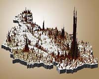
Paris, France (ESA) Apr 27, 2006 In response to a growing demand for sharpened census data, GeoVille Information Systems has developed 'real-world population' maps based on Earth observation, under a contract named EO-STAT awarded by ESA, which can assist the private and public sector in fields such as geomarketing, market research, business location analysis, risk assessment and transport and urban planning. GeoVille, an Austrian company specialising in geo-information, and Tele Atlas, the largest manufacturer of road networks worldwide, are providing detailed models of areas based on road network information, statistical population data � supplied by the German-based market research institute GfK � and Earth observation (EO) images from ESA's Envisat, NASA's LANDSAT and the French Space Agency's SPOT satellites. Results are then integrated into Tele Atlas' digital geographic database, MultiNet, and can � among other applications � be used to spot the target groups for geomarketing campaigns. Geomarketing determines consumer profiles according to geographical zones based on market-specific data by using geographical information along with population and economic statistics. Companies can use this information to visualize the geographic location of potential target groups before implementing costly marketing campaigns and to envision future growth on a local or national scale. For instance, this information can be used to strategically choose a heavily-populated area in which to place a business in another country without ever placing a foot in the region. Population data from zip codes has been used for decades to help companies reach their target audience, but that data has drawbacks because it standardises the information, conveying the erroneous impression of homogeneous population densities leading to misleading results. Data provided by EO-STAT (EO derived information for sharpening socio-economic STATistics) makes the transition from the current population statistics to the 'real-world' population situation. "Models based on zip code data, for example, make areas look uniform, but in reality within a community you will have, for instance, some high rise buildings, single family homes, some green areas, lakes and parks," Christian Hoffman of GeoVille said. "Our service is like a pencil sharpener because it sharpens the data already available by using a model that compiles three layers of information." Information on 'real-world population' distribution is already available through EO-STAT for all of Austria with extensions in Germany, but the largest potential of the project is in regions and countries where limited information on population distribution is available. Thus, EO-STAT is currently working to provide models for Eastern European countries, where the statistical data are sometimes fragmented not homogeneous. In light of the European Union's expansion to the east, there is an increasing demand for geoinformation from this region to allow local and national businesses to make better informed decisions. GeoVille is also currently providing maps over the province of Shanghai in China. GeoVille first employed this technique in Vienna, Austria, with a population of roughly 1.5 million, and illustrated a complex and heterogeneous settlement structure from low density single family neighbourhoods to modern high-rise buildings and large industrial and commercial areas. The model produced was validated with aerial photographs and independent reference data and showed an accuracy of more than 95 percent. The EO data used provided recognition of urban features and separation of urban from non-urban features, as well as discrimination of urban site density based on the presence of vegetation. Companies currently using this model expect to improve their existing data sets in regards of accuracy by a factor of 100 or more. The EO-STAT service is organised in partnership with German-based Infoterra GmbH and Brockmann Consult. The EO-STAT contract was awarded by ESA within the framework of the Earth Observation Market Development (EOMD) programme. More information about EO-STAT activities is available from the EOMD website or can be obtained by contacting [email protected]. Related Links GeoVille Earth Observation Market Development (EOMD)
 Taiyuan, China (XNA) Apr 28, 2006
China successfully launched a remote sensing satellite and put it into preset orbit Thursday morning, the first of a series of space launches planned by China this year. |
|
| The content herein, unless otherwise known to be public domain, are Copyright 1995-2006 - SpaceDaily.AFP and UPI Wire Stories are copyright Agence France-Presse and United Press International. ESA PortalReports are copyright European Space Agency. All NASA sourced material is public domain. Additionalcopyrights may apply in whole or part to other bona fide parties. Advertising does not imply endorsement,agreement or approval of any opinions, statements or information provided by SpaceDaily on any Web page published or hosted by SpaceDaily. Privacy Statement |