| . |  |
. |
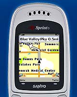
Olathe KS (SPX) Sep 13, 2005 Garmin International, a unit of Garmin, has announced that Garmin Mobile - a new suite of applications delivering maps, directions, and turn-by-turn navigation - will be offered by Sprint Nextel on select handsets. Garmin Mobile represents Garmin's first product offering that targets the emerging wireless handset applications and location-based services market. "Garmin Mobile exposes an entirely new group of consumers to turn-by-turn satellite navigation," said Gary Kelley, Garmin's vice president of marketing. "We are thrilled that Sprint Nextel, an industry leader in voice and data communications, has chosen Garmin to provide these exciting new applications and location-based services to their customers." Based on Garmin's highly acclaimed StreetPilot "c-series," Garmin Mobile is easy to use and offers users extreme utility especially when traveling in unfamiliar areas. Users can navigate to an address anywhere in the United States and Puerto Rico, or search millions of points of interest (POI's) - places like hotels, restaurants, shopping, and tourist attractions. Users can also dial the POI's phone number automatically - for reservations, hours of operation, or other information. Once users choose a destination, Garmin Mobile automatically calculates the fastest route to the destination, and provides voice-prompted turn-by-turn directions along the way while the customer is on the Sprint PCS Nationwide Network. Garmin Mobile's text-to-speech functionality allows the unit to audibly announce the name of upcoming streets - letting drivers keep their eyes on the road while navigating through busy traffic and tricky roadways. If users stray off course, Garmin Mobile will automatically calculate the quickest way to get back on track. Map data is provided by NAVTEQ - a world leader in premium-quality mapping. Garmin Mobile is also the first server-based navigation application that visually depicts and constantly updates the user's position on a detailed moving map - giving the user additional situational awareness. The user interface also announces upcoming turns in an easy-to-read text and arrow format. Users can also manage their destinations and personal locations online by accessing the Garmin Mobile Manager website. To improve the utility of using the phone in an automobile, customers may purchase an automotive phone mount for $19.99 at the Garmin Mobile website. Garmin Mobile is available on a number of Sprint handsets, including select Sprint PCS Multimedia Phones. Current Sprint PCS Vision subscribers using these models can download the Garmin Mobile application to their phone from Sprint PCS Vision and customers can subscribe to Garmin Mobile now for $9.99 per month. Related Links Garmin Mobile SpaceDaily Search SpaceDaily Subscribe To SpaceDaily Express
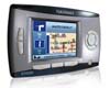 Foothill Ranch CA (SPX) Sep 13, 2005
Navman has announced the expansion of its consumer electronics and automotive personal navigation product line. The new Navman iCN 320 is a pocket-sized guidance system designed to offer truly usable guidance technology to the masses, providing users with a wealth of exciting new convenience and performance features for effective navigation. |
|
| The content herein, unless otherwise known to be public domain, are Copyright 1995-2006 - SpaceDaily.AFP and UPI Wire Stories are copyright Agence France-Presse and United Press International. ESA PortalReports are copyright European Space Agency. All NASA sourced material is public domain. Additionalcopyrights may apply in whole or part to other bona fide parties. Advertising does not imply endorsement,agreement or approval of any opinions, statements or information provided by SpaceDaily on any Web page published or hosted by SpaceDaily. Privacy Statement |