| . |  |
. |
| . | |
. |
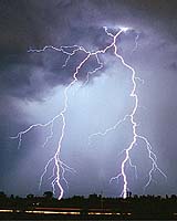
Tucson - Dec 11, 2003 When it comes to predicting rainfall during convective thunderstorms, lightning may be more accurate than radar in determining precipitation intensity and location, say University of Arizona atmospheric scientists. Lightning could become a powerful forecasting tool allowing meteorologists to predict flooding by monitoring the intensity of lightning. This would be especially valuable in areas that are hidden from radar by natural features such as mountains or in areas that are too far offshore to monitored by radar. The researchers include E. Philip Krider of UA's Institute of Atmospheric Physics; Bruce Gungle, a UA graduate now with the U.S. Geological Survey in Tucson; and Nicole M. Kempf, a UA graduate now with the National Weather Service in Tulsa, Okla. They have shown that there is a reproducible, quantitative relationship between the amount of rainfall associated with each cloud-to-ground lightning flash. Their results come from two independent studies. Gungle will discuss the research on Wednesday afternoon, Dec. 10, at the American Geophysical Union meeting in San Francisco. "We found that lightning is a good tool for predicting rain volume, and it doesn't matter if it's a big storm or a small storm," Krider said. "It depends more on the type of storm." "We know that clouds that have intense vertical development, or those that extend high up into the atmosphere are the ones that give predictable lightning-to-rain-volume ratios," Krider explained. "These clouds contain both super-cooled water and ice. Other clouds, such as smaller 'stratiform' clouds, aren't so large vertically and the rain formation mechanism is dominated by water-water collisions without ice. Those clouds don't produce the well-correlated lightning-to-rain volume relationship." Krider and Gungle measured this relationship in studies conducted at the NASA Kennedy Space Center and Cape Canaveral Air Force Station in Florida. Gungle monitored lightning strikes and rainfall in single, isolated thunderstorms as these storms moved across the Florida site, which is approximately a square with 40-kilometer (25-mile) sides. The site is covered with a network of rain gauges and lightning sensors. Warm-season thunderstorms consistently produced about 15,000 cubic meters of rainfall for each cloud-to-ground strike. That's equivalent to about 12 acre-feet or 4 million gallons per strike, Gungle found. Nicole Kempf and Krider collaborated on a separate large-scale study. Those results were reported last February at an American Meteorological Society meeting and published in the Monthly Weather Review last June. They studied relationships between cloud-to-ground lightning and surface rainfall over the Greater Upper Mississippi River Basin during the Great Flood of 1993 -- considered one of the worst natural disasters in recent history. The flood affected 30 percent of the Mississippi River Basin, killed 52 people, and caused more than $18 billion in property damage. Fourteen rivers reached record water levels and overflowed their banks, and 536 counties were declared federal disaster areas. Kempf and Krider correlated results from three databases collected during the summer of 1993:
* The number of cloud-to-ground lightning strikes reported by the U.S. National Lightning Detection Network They found a strong relationship between the daily rain volumes and the corresponding counts of cloud-to-ground lightning. The National Lightning Detection Network recorded 3.6 million cloud-to-ground lightning flashes over the Greater Upper Mississippi River Basin during June, July and August 1993. Correcting for imperfect network detection efficiency, that figure is actually closer to 5.4 million, the scientists concluded. The National Weather Service rain gauge network measured 650 billion cubic meters of rainfall for the region during the same period. The UA scientists found that each cloud-to-ground strike was associatd with 130,000 cubic meters of rain. That is about 34 million gallons, or 105.4 acre-feet, per strike. "It appeared to be almost the same rain volume, day in and day out, for about 100 days," Krider said. "The rain volume does go slightly up and down, because rain sampling isn't perfect, but it does fit a statistically testable, strong relationship. In these large 'mesoscale' convective systems, you can see where the lightning is, count the flashes, and immediately have an estimate of surface rainfall." Krider is attending the AGU meeting in San Francisco, where he will give an invited talk on current lightning detection systems. Related Links University of Arizona USGS SpaceDaily Search SpaceDaily Subscribe To SpaceDaily Express
 San Francisco - Dec 11, 2003
Using the perspective of the last few centuries and millennia, speakers in a press conference at the Fall Meeting of the American Geophysical Union in San Francisco will discuss the latest research involving climate reconstructions and different climate models. |
|
| The content herein, unless otherwise known to be public domain, are Copyright 1995-2006 - SpaceDaily.AFP and UPI Wire Stories are copyright Agence France-Presse and United Press International. ESA PortalReports are copyright European Space Agency. All NASA sourced material is public domain. Additionalcopyrights may apply in whole or part to other bona fide parties. Advertising does not imply endorsement,agreement or approval of any opinions, statements or information provided by SpaceDaily on any Web page published or hosted by SpaceDaily. Privacy Statement |