| . |  |
. |
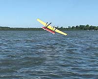
Ann Arbor MI (SPX) Dec 06, 2007 Flying fish were the inspiration for an unmanned seaplane with a 7-foot wingspan developed at the University of Michigan. The autonomous craft is believed to be the first seaplane that can initiate and perform its own takeoffs and landings on water. Funded by the Department of Defense's Defense Advanced Research Projects Agency (DARPA), it is designed to advance the agency's "persistent ocean surveillance" program. Engineering researchers from U-M recently returned from sea trials off the coast of Monterey, Calif., where they demonstrated the craft's capability to DARPA officials. "The vehicle did very well," said Hans Van Sumeren, associate director of the U-M Marine Hydrodynamics Laboratories. "To take off and land in the water was a big effort. We did it 22 times." The researchers named the robotic plane Flying Fish after its inspiration. Guy Meadows, director of the U-M Marine Hydrodynamics Laboratories, conceived of the design while out on the water. "I saw these fish pop up and soar over the waves," Meadows said. That got Meadows and his colleagues looking at sea birds for a design for their craft. "We studied sea birds seriously," Meadows said. "They're all about the same size---about 20 pounds with a 2-meter wingspan. It turns out that, aerodynamically speaking, that's a sweet spot to be flying close to the water. Our plane is about the size of a large pelican." Flying Fish, an electric vehicle, drifts until its onboard Global Positioning System tells the craft it has floated too far. That triggers the takeoff sequence, which gets the plane airborne in just 10 meters. Other GPS coordinates trigger the landing sequence. The craft accomplishes both in simple ways, explained Ella Atkins, associate professor of aerospace engineering and associate professor of electrical engineering and computer science. The flight pattern is, for the most part, a recording of a graduate student's piloting of the plane. That means the takeoff is blind, Atkins explained. The plane takes no measurements of its surroundings. The waves would confuse it. "Most people wouldn't do it this way," Atkins said. "The plane puts the motors on at full throttle and sets the pitch elevator enough to break out of the water. Then it counts and pitches forward. We believe that if we had done it any other way, we would have basically dived into the ocean on takeoff because the plane would have detected huge oscillations due to the waves." The landing is basically a shallow descent. "When it impacts the water, it goes, 'Oh, there's the water,'" Akins said. "The boat has very well-designed pontoons. Because it doesn't have a flat bottom, it cuts into the water like a diver, as opposed to belly-flopping." The craft was a collaborative effort among researchers in the departments of Naval Architecture and Marine Engineering, Electrical Engineering and Computer Science and Aerospace Engineering. Next, the team plans to outfit the plane with solar power and add more sensors.
Community Email This Article Comment On This Article Related Links Flying Fish Project UAV News - Suppliers and Technology
 St. Louis MO (SPX) Dec 05, 2007
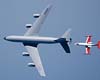
Can an unmanned air vehicle be made smart enough to autonomously rendezvous with a tanker aircraft and refuel? Based on recently concluded flight tests by the U.S. Air Force Research Laboratory and Boeing [NYSE: BA], it can. "By adding an automated aerial refueling capability to UAVs, we can significantly increase their combat radius and mission times while reducing their forward staging needs and response times," said David Riley, Boeing Phantom Works program manager for the Automated Aerial Refueling (AAR) program. |
|
| The content herein, unless otherwise known to be public domain, are Copyright 1995-2007 - SpaceDaily.AFP and UPI Wire Stories are copyright Agence France-Presse and United Press International. ESA Portal Reports are copyright European Space Agency. All NASA sourced material is public domain. Additional copyrights may apply in whole or part to other bona fide parties. Advertising does not imply endorsement,agreement or approval of any opinions, statements or information provided by SpaceDaily on any Web page published or hosted by SpaceDaily. Privacy Statement |