| . |  |
. |
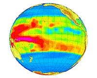
Paris, France (SPX) March 3, 2006 ESA scientists said Friday that recent satellite measurements of a significant difference in sea-surface height between the western and eastern tropical Pacific Ocean suggest a La Nina event is beginning. El Nino's chillier sister, La Nina also is linked to wide-ranging shifts in weather patterns. Hundreds of years ago, fishermen off the west coast of Peru noted how the waters grew unusually warm periodically around Christmas, causing fish to become scarce. They named the phenomenon "the Christ Child," or El Nino. It begins when a mass of warmer water from the western Pacific moves east, displacing cooler, nutrient-rich waters in the vicinity. This warmer water adds moisture to the atmosphere. It also raises rainfall levels and disrupts atmospheric circulation around the globe. La Nina is an equivalent cooling event, during which the warm waters shift westward and are replaced by an upwelling of cold water. This reduces rainfall in the eastern equatorial Pacific, but increases it in the west. Climate scientists now recognize El Nino and La Nina as components of a larger phenomenon that extends to the atmosphere, called the El Nino Southern Oscillation, or ENSO. In the 1920s, British meteorologist Gilbert Walker noticed seasonal fluctuations in the air-pressure difference across the equatorial Pacific, which he called the Southern Oscillation. Then, in the 1960s, scientists linked this phenomenon to El Nino and La Nina events. ENSO variations can widely influence weather patterns, and scientists are attempting to use all available data to understand ENSO's effects and improve weather forecasting. The latest data from ESA's Envisat show differences in sea-surface height of 60 centimeters (23 inches) between the western and eastern Pacific. The satellite's radar altimeter instrument can bounce 1,800 pulses per second off the ocean's surface, and determine its height within 2 centimeters (two-thirds of an inch). The sea-level data correlates with other sources, including the 70 buoys of the U.S. Tropical Ocean Atmosphere array running across the equatorial Pacific, the Japanes TRIangle Trans-Ocean Network buoy array, and more than 2,000 global Argo profiling floats, which provide temperature and salinity readings at various ocean depths. Based on this information, and other sources, researchers said the conditions for a weak La Nina are in place, with the event likely to last into late spring and possibly summer. "The development of a negative anomaly does seem to be well in hand," said Christophe Maes, of the Institut de Recherche pour le D�veloppement in New Caledonia. "It will still take a few months for the scientific community to better comprehend what is going on, because the system has often surprised us in the past." La Nina will be marked by shifts in global atmospheric circulation patterns, because colder-than-normal waters in the eastern tropical Pacific will tend to suppress rainfall in the vicinity, at the same time as increasing it to the west. Wetter-than-normal conditions will occur over northern Australia and Indonesia, the researchers said, as well as over the Philippines during the northern hemisphere summer. The Indian monsoon rainfall probably will increase, particularly in the northwestern part of the country. South America's tropical west coast will undergo a drier-than-normal winter. These shifts will affect the position and weaken the intensity of the global jet streams and the behavior of storms occurring beyond the tropics in both hemispheres. There should be a summer decrease in hurricane activity in the eastern tropical North Pacific, and a corresponding increase in the number of hurricanes in the tropical North Atlantic. The last La Nina took place during 2000-2001. It was a weak event compared to the previous La Nina in 1998-2000. That La Nina and its cousin in 1988-89 are considered the standards. ESA has been flying radar altimeters in space ever since the launch of ERS-1 in 1991, amassing a continuous 15 year dataset that covers not only the global ocean but also freshwater bodies, land surfaces and the planet's ice caps. ESA plans to extend the archive when another radar- altimeter instrument is launched on the Sentinel-3 satellite in 2010. That mission will support the Global Monitoring for Environment and Security initiative of the European Union and ESA. Related Links Envisat ESA
 Virginia Key FL (SPX) Mar 03, 2006
Shipping companies can route ships more safely and efficiently. Ocean search-and-rescue can operate more effectively. Meteorologists and climatologists now have a tool to provide long-range weather prediction more accurately. Navies too can perform more accurate anti-submarine surveillance. |
|
| The content herein, unless otherwise known to be public domain, are Copyright 1995-2006 - SpaceDaily.AFP and UPI Wire Stories are copyright Agence France-Presse and United Press International. ESA PortalReports are copyright European Space Agency. All NASA sourced material is public domain. Additionalcopyrights may apply in whole or part to other bona fide parties. Advertising does not imply endorsement,agreement or approval of any opinions, statements or information provided by SpaceDaily on any Web page published or hosted by SpaceDaily. Privacy Statement |