| . |  |
. |
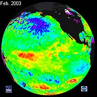
Huntsville - Mar 17, 2003 Sometimes Earth scientist Bill Patzert wishes he had a degree in psychology. It might help him understand El Nino. "Every El Nino has a personality all its own, and the latest one has been very quirky," says Patzert, who works at NASA's Jet Propulsion Laboratory. "Here in southern California we expect El Nino to bring heavy rains. But the weather this winter has had a split-personality, alternating between warm and dry months to very cold and wet months." Strange. But it's not just southern California. Other parts of the world have had quirky El Nino weather, too. El Nino is a global weather disturbance that comes along every 4 to 7 years when trade winds blowing across the Pacific Ocean weaken or even reverse. (Why they do this, no one knows.) Normally these winds blow from the Americas toward Australia, pushing sun-warmed surface waters from east to west. "Warm water accumulates near Australia in a region we call 'the warm pool,'" says Patzert. What happens when the trade winds falter? "That warm water sloshes eastward back across the Pacific Ocean. We can see it in NOAA and NASA satellite maps of sea surface temperature and sea surface height: a band of warmer, higher water stretching along the equator from the mid-Pacific to the coasts of Peru and Ecuador." This warm strip has multiple influences on global patterns of winds and humidity. For instance, it diverts the course of the jet stream--a "conveyor belt" for storms--which in turn affects weather over much of the globe, especially the North American continent. In terms of Pacific sea surface temperatures, the 2002-03 El Nino has been far milder than the mammoth El Nino of 1997-98. Recent images from the NASA/CNES Jason-1 satellite show that the mid-equatorial Pacific was only 2�C warmer than average in 2002, compared to the huge, long-lasting tongue of water that was as much as 5�C warmer than average and piled up along the coasts of the Americas in 1997. But don't call this El Nino "weak." It's more complicated than that. In some places its effects have been unusually severe. "Take Australia, for example," says Patzert. "El Nino typically causes dry weather and droughts there--and this year is no exception. What's curious is that the drought of 2002 (when El Nino was mild) is worse than the drought of 1997 (when El Nino was strong)." Meanwhile in Ecuador and Peru, countries where El Nino usually brings torrential rains and flooding, the 2002 El Nino has had little effect. New England has also experienced contrary weather: The El Nino winter of 1997 was unusually warm. This winter it has been bitterly cold. "This El Nino definitely has a different personality than the one in 1997-98," Patzert says. Patzert speculates that the 2002 El Nino is both milder and quirkier than the last one because of something called "the Pacific Decadal Oscillation" (PDO). The PDO is a subtle pattern of sea surface temperatures in the Pacific Ocean. "It looks like a horseshoe nearly as large as the Pacific Ocean itself, slowly shifting between warm and cool phases every 20-30 years." Somehow--no one knows the details--the PDO influences El Nino: If El Nino begins during a cool phase of the PDO, El Nino tends to be milder and less predictable. El Ninos that come during a warm PDO are stronger and "better behaved, in the sense that we can predict their consequences," he says. In 1997-98 the PDO was in a warm phase--hence the strong El Nino. Since then the PDO has cooled. "Tropical ocean surface temperatures surrounding El Nino's warm patch now are less like they were in '97-98 and more like they were during the '50s, '60s and early '70s--the last time the PDO was in a cool phase and El Ninos were relatively mild," says Patzert.
What's next? Patzert, however, thinks this El Nino is nearing its end. "The latest sea surface temperature and sea level maps from space show a cooling trend in the equatorial Pacific." The warm strip of El Nino is giving way to a cool band of water that might herald "La Nina." "When the trade winds return, they often return with a vengeance," he explains. Not only do they push the warm surface waters back toward Australia, but also they drag cooler-than-usual waters up from the depths. "This is what we call La Nina. She has weather patterns all her own. In this case La Nina would probably mean continuing drought across much of the western U.S." he says. La Nina often, but not always, follows El Nino. In 1998 the transition happened in the month of May. This time it seems to be happening in March--again, quirky. "We'll have to wait and see," cautions Patzert. The El Nino of 2002 may have more surprises in store. Anything else would be out of character. Related Links NOAA's El Nino Home Page SpaceDaily Search SpaceDaily Subscribe To SpaceDaily Express
 Corvallis - Mar 17, 2003
Global warming and the partial melting of polar ice sheets can dramatically affect not only sea levels but also Earth's climate, in ways that may be complex, rapid and difficult to adjust to, scientists say in a new study to be published Friday in the journal Science. |
|
| The content herein, unless otherwise known to be public domain, are Copyright 1995-2006 - SpaceDaily.AFP and UPI Wire Stories are copyright Agence France-Presse and United Press International. ESA PortalReports are copyright European Space Agency. All NASA sourced material is public domain. Additionalcopyrights may apply in whole or part to other bona fide parties. Advertising does not imply endorsement,agreement or approval of any opinions, statements or information provided by SpaceDaily on any Web page published or hosted by SpaceDaily. Privacy Statement |