| . |  |
. |
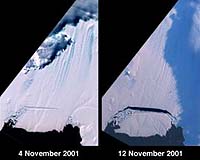
Pasadena - Nov 18, 2001 To the surprise of scientists, a large iceberg has broken off the Pine Island Glacier in West Antarctica well in advance of predictions. The new iceberg detached from the glacier when a crack, which initially formed in mid-2000, spread rapidly until it reached the breaking point. The iceberg's birth was captured in a series of images taken by NASA's Multi-angle Imaging SpectroRadiometer. These images, combined with previous measurements and data from other instruments, provide scientists with additional evidence of rapid change in the region. A large tabular iceberg (42 kilometers x 17 kilometers) broke off Pine Island Glacier, West Antarctica (75�S latitude, 102�W longitude) sometime between November 4 and 12, 2001. Images of the glacier were acquired by the Multi-angle Imaging SpectroRadiometer (MISR) instrument aboard NASA's Terra spacecraft. This event was preceded by the formation of a large crack across the glacier in mid 2000. Data gathered by other imaging instruments revealed the crack to be propagating through the shelf ice at a rate averaging 15 meters per day, accompanied by a slight rotation of about one percent per year at the seaward margin of the rift. The image set shows three views of Pine Island Glacier acquired by MISR's vertical-viewing (nadir) camera. The first was captured in late 2000, early in the development of the crack. The second and third views were acquired in November 2001, just before and just after the new iceberg broke off. The existence of the crack took the glaciological community by surprise, and the rapid rate at which the crack propagated was also not anticipated. Glaciologists predicted that the rift would reach the other side of the glacier sometime in 2002. However, the iceberg detached much sooner than anticipated, and the last 10-kilometer segment that was still attached to the ice shelf snapped off in a matter of days. The animated sequence consists of 11 snapshots acquired by MISR's nadir camera between September 16, 2000 and November 12, 2001. Due to frequent cloud cover, the time interval between successive frames is not uniform. The flow of the glacier, widening of the rift, and subsequent break-off of the iceberg are evident. A "jump" in the position of the rift near the middle of the sequence is due to a gap in image acquisition during Antarctic winter, when the glacier was in continuous darkness. Pine Island Glacier is the largest discharger of ice in Antarctica and the continent's fastest moving glacier. This area of the West Antarctic Ice Sheet is also believed to be the most susceptible to collapse. The evolution of this glacier is therefore of great interest to the scientific community. "The climatic significance of this calving event is not yet clear, but is taking place in an area of Antarctica which is experiencing rapid changes", said glaciologist Eric Rignot of the Jet Propulsion Laboratory. Rignot points out that the grounding line of Pine Island Glacier is retreating, the glacier is thinning rapidly, and its ice flow is accelerating. Additionally, the sea ice cover in front of the glacier has been decreasing steadily for several decades. The newly hatched berg represents nearly seven years of ice outflow from Pine Island Glacier released to the ocean in a single event. Although this has no effect on sea level (the ice is already afloat), it is an exceptional event for this glacier, and provides additional evidence that this area is undergoing rapid change. The Multi-angle Imaging SpectroRadiometer, built and managed by NASA's Jet Propulsion Laboratory, Pasadena, Calif., is one of several Earth-observing experiments aboard the Terra satellite, launched in December 1999. The instrument acquires images of Earth at nine angles simultaneously, using nine separate cameras pointed forward, downward, and backward along its flight path. Related Links Multi-angle Imaging SpectroRadiometer SpaceDaily Search SpaceDaily Subscribe To SpaceDaily Express
 Boston - May 29, 2001
Scientists studying the oceans depend on data from rivers to estimate how much fresh water and natural elements the continents are dumping into the oceans. But a new study in the Aug. 24 issue of Science finds that water quietly trickling along underground may double the amount of debris making its way into the seas. This study changes the equation for everything from global climate to understanding the ocean's basic chemistry. |
|
| The content herein, unless otherwise known to be public domain, are Copyright 1995-2006 - SpaceDaily.AFP and UPI Wire Stories are copyright Agence France-Presse and United Press International. ESA PortalReports are copyright European Space Agency. All NASA sourced material is public domain. Additionalcopyrights may apply in whole or part to other bona fide parties. Advertising does not imply endorsement,agreement or approval of any opinions, statements or information provided by SpaceDaily on any Web page published or hosted by SpaceDaily. Privacy Statement |