| . |  |
. |
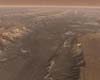
Tempe AZ (SPX) Mar 13, 2006 Valles Marineris is the hardest spot on Mars to mosaic," says Chris Edwards of Arizona State University. "But what makes this mosaic cool are the super-fine details THEMIS recorded." Valles Marineris, or Mariner Valley, forms the largest canyon in the solar system. The new mosaic shows the valley, which extends 3,000 kilometers (2,000 miles), including its westward extension through Noctis Labyrinthus. This is long enough to reach from New York to Los Angeles, and the canyon's steep walls rise almost as high as Mt. Everest. The mosaic combines 556 infrared photos from the Thermal Emission Imaging System (THEMIS), an instrument aboard NASA's Mars Odyssey orbiter. Mars Odyssey was built by Lockheed Martin and the mission is operated by the Jet Propulsion Laboratory. THEMIS takes photos in visible and infrared light, scanning the planet as Mars Odyssey follows its 2-hour orbits. Infrared images taken by THEMIS record details just 100 meters (330 feet) across; the photos come from the spacecraft as long strips, each 32 kilometers (20 miles) wide. The oldest image in the mosaic was taken February 21, 2002. This was soon after Mars Odyssey began scientific operations, following its arrival at Mars in October 2001. The most recent mosaic image dates from November 5, 2005. The mosaic is the work of Christopher Edwards, 22, a senior undergraduate student in geosciences at Arizona State University in Tempe. Using software developed by Noel Gorelick at ASU's Mars Space Flight Facility, Edwards assembled the new high-resolution mosaic, initially choosing images from those already taken. He then directed mission controllers to shoot additional frames to fill gaps in coverage. THEMIS' infrared images, taken during daytime, record heat radiation coming from the ground. Edwards explains that because the frames in the video appear in the order they were taken, you can watch seasonal effects take place as the video runs. "We started off in a nice, warm time," he says. "Then the martian season turned colder, and the images got darker." When the mosaic project was in full swing, images were arriving from practically every orbit. By then, however, the season had turned warmer, producing brighter scenes. Eventually, notes Edwards, he had to carefully process away the brightness variations to smooth the mosaic without losing surface details. "This was a tough data set to work with," he says. "You have to blend images taken at different times of day and different lighting conditions. These produce varying shadows that make the ground look different from one image to the next." As the video shows, the images were taken in a sequence that runs generally from right to left, reflecting the evolution of Mars Odyssey's orbit. But assembling the mosaic proceeded in the opposite direction. "The reason we mosaic from left to right is for ease of blending and correct placement," Edwards explains. "The software works by locating on the planet the upper left pixel of each image, so going from left to right makes it easier to tack on the next image." While the mosaic doesn't include every image of Valles Marineris that THEMIS took, all of them contributed. Whenever a better frame came down from the spacecraft, Edwards used it to replace one that was imperfect, due to clouds or haze, perhaps. In total, some 800 images were sifted for the mosaic. Says Edwards, "This is the best of the best." Looking back on the job, he jokes, "This mosaic ate six months of my life - I sure hope people like it!" Related Links Mars Video
 Tempe AZ (SPX) Mar 14, 2006
A ragged geological scar crosses the belly of Mars. Long enough to reach from New York City to Los Angeles, this great rift in the martian crust is named Valles Marineris, or Mariner Valley. It was discovered in 1972 by the Mariner 9 spacecraft. |
|
| The content herein, unless otherwise known to be public domain, are Copyright 1995-2006 - SpaceDaily.AFP and UPI Wire Stories are copyright Agence France-Presse and United Press International. ESA PortalReports are copyright European Space Agency. All NASA sourced material is public domain. Additionalcopyrights may apply in whole or part to other bona fide parties. Advertising does not imply endorsement,agreement or approval of any opinions, statements or information provided by SpaceDaily on any Web page published or hosted by SpaceDaily. Privacy Statement |