| . |  |
. |
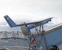
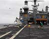
St Louis MO (SPX) May 19, 2006 The ScanEagle unmanned aerial vehicle, developed by Boeing and The Insitu Group, successfully demonstrated new maritime capabilities for the United Kingdom Ministry of Defence (MoD) while supporting "Trial Vigilant Viper" off the Scotland coast. The trial's goal was to evaluate how a low-cost intelligence, surveillance and reconnaissance (ISR) platform can contribute to amphibious operations. Working with Thales and QinetiQ as part of the Joint UAV Experimentation Program, ScanEagle during 10 flights completed autonomous launch and recovery operations from a Type 23 Frigate in rough sea conditions. Missions included land and sea surveillance, beach reconnaissance, force protection, maritime interdiction and naval gunfire support. "This program marks a major endorsement of ScanEagle's ISR capabilities, which have the potential to enhance future amphibious operations," said Steve Krause, Boeing Advanced Systems Business Development lead. "Equally significant is the fact that ScanEagle conducted the first autonomous take off and recovery from a UK warship, the Type 23 Frigate HMS Sutherland." As part of Trial Vigilant Viper, ScanEagle used its onboard electro-optical and infrared sensors to identify potential threats as small as jet skis. ScanEagle's ability to determine a target's position, direction of travel and velocity, coupled with its broadcast quality imagery, enabled amphibious force commanders to establish the nature of potential threats. The UAV's contribution to force protection included transmitting real-time high resolution video to ship, shore, a Sea King AEW MK7 helicopter and the MoD in London and Portsmouth, England. Integration of a UAV into the maritime intelligence, surveillance, target acquisition and reconnaissance environment was a key goal of the trials. The trials also helped the MoD investigate the utility of a small UAV supporting Royal Navy ships conducting gunfire support missions. ScanEagle observed fall of shot, successfully passing the data to a gunfire controller for corrections. In the future, it may be possible to control naval gunfire support with "verification of target" as the only human user input. The U.S. Navy is currently using ScanEagle to provide critical ISR data in support of Expeditionary Strike Group missions and oil platform security. The Insitu Group, located in Bingen, Wash., develops unmanned aerial systems for commercial and military applications. Insitu, which introduced the first unmanned aerial vehicle to cross the Atlantic Ocean, also developed the Fugro GeoRanger and worked with Boeing to develop ScanEagle. Related Links Boeing The Insitu Group
 Hebrides Range, Scotland (SPX) May 19, 2006
Team JUEP (Joint UAV Experimentation Programme) � Boeing/Insitu, QinetiQ and prime contractor Thales UK � has successfully completed the GBP3 million third phase of maritime trials, including the launch and recovery of an Unmanned Aerial Vehicle (UAV) to Royal Navy frigate HMS Sutherland. |
|
| The content herein, unless otherwise known to be public domain, are Copyright 1995-2006 - SpaceDaily.AFP and UPI Wire Stories are copyright Agence France-Presse and United Press International. ESA PortalReports are copyright European Space Agency. All NASA sourced material is public domain. Additionalcopyrights may apply in whole or part to other bona fide parties. Advertising does not imply endorsement,agreement or approval of any opinions, statements or information provided by SpaceDaily on any Web page published or hosted by SpaceDaily. Privacy Statement |