| . |  |
. |
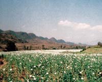
Guildford, UK (SPX) Oct 24, 2006 After extensive trials in 2005, DMC International Imaging Ltd. (DMCii) won a contract from the UK Government to supply high-resolution satellite coverage of the whole of Afghanistan to support the surveying of opium crops. The Disaster Monitoring Constellation (DMC) coordinated by DMCii includes the UK's own satellite, as well as four satellites built at the Surrey Space Centre for other DMC member nations; Algeria, China, Nigeria and Turkey. Full country coverage at this resolution can be achieved because, unlike single satellites, the Disaster Monitoring Constellation is able to revisit an area every day. This enables data to be collected rapidly and the problems of cloud to be avoided. DMC images were timed to match the peak in crop growth in different areas of the country. The 32metre resolution multispectral data enables crop characteristics to be measured at a field level, and the 600km wide images help analysts to unify the opium crop estimates from other data sources, including ground surveys, aerial photos and very high resolution satellite spot samples. The UK Foreign and Commonwealth Office (FCO) stated; "The FCO welcomes the role played by DMC in accurately measuring opium cultivation in Afghanistan. Detailed information is important in assisting the Afghan Government in implementing their Counter Narcotics Strategy." DMCii's Marketing Director, Paul Stephens, said; "This is the first time that a full country survey of Afghanistan at 32 metre resolution has been carried out to coincide with the peak of the opium poppy crop. It really uses the strengths of the international DMC satellites to the full. The constellation of low cost small satellites enables us to monitor wide areas at a useful level of detail, and can keep repeating the images frequently until we get a cloud free shot. We are delighted that our orthorectified data received gold stars for precision, timeliness and quality from the analysts." Opium cultivation in Afghanistan rose 59 percent in 2006, the United Nations Office on Drugs and Crime (UNODC) said on 2nd September. UNODC's Annual Opium Survey for Afghanistan showed the area under opium cultivation reached a record 165,000 hectares in 2006 compared with 104,000 in 2005. About DMC International Imaging Ltd DMC International Imaging Ltd. (DMCii) is a UK supplier of remote sensing data products and services for international Earth Observation (EO) markets. DMCii supplies programmed and archived optical satellite imagery provided by the multi-satellite Disaster Monitoring Constellation (DMC). DMC data is now used in a wide variety of commercial and government applications including agriculture, forestry and environmental mapping. The small satellites of the DMC provide daily revisit in combination with an unmatched 600km imaging swath width at 32 metre ground sample distance (GSD) for frequent broad area coverage. DMC data products are calibrated and processed to a variety of levels according to customer requirements. In partnership with the British National Space Centre (BNSC) and the other DMC member nations (Algeria, China, Nigeria, Turkey) DMCii uses the commercial exploitation of the DMC small satellite constellation to fund co-ordination of the DMC for humanitarian use in the event of major international disasters. DMCii works with the UN, the European Space Agency and The International Charter: Space and Major Disasters during disasters such as Tsunami, Fire, Flooding and Hurricanes. Related Links DMC International Imaging SSTL's Space blog Making money out of watching earth from space today
 Surrey UK (SPX) Oct 11, 2006
Deimos Imaging SL, a subsidiary of Deimos Space SL, and Surrey Satellite Technology Ltd (SSTL) have announced a contract for an Earth imaging satellite, DEIMOS. The satellite will be built by SSTL to be ready for launch early in 2008 and will form part of the Disaster Monitoring Constellation (DMC). The satellite will provide imagery for commercial applications, for government use and for rapid-response following disasters. |
|
| The content herein, unless otherwise known to be public domain, are Copyright 1995-2006 - SpaceDaily.AFP and UPI Wire Stories are copyright Agence France-Presse and United Press International. ESA PortalReports are copyright European Space Agency. All NASA sourced material is public domain. Additionalcopyrights may apply in whole or part to other bona fide parties. Advertising does not imply endorsement,agreement or approval of any opinions, statements or information provided by SpaceDaily on any Web page published or hosted by SpaceDaily. Privacy Statement |