| . |  |
. |
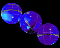
Pasadena CA (JPL) Nov 18, 2005 This set of images shows the areas mapped so far on Saturn's moon Titan by the Cassini radar mapper using its synthetic aperture radar imaging mode. Labels represent the approximate central longitude of each globe. The radar swaths are superimposed on a false-color image made from observations by NASA's Hubble Space Telescope. The top image shows radar swaths from the first Titan flyby, on Oct. 26, 2004, (northernmost) and the second radar pass of Titan, on Feb. 15, 2005 (near-equatorial). The Oct. 26 swath is about 4,500 kilometers long (2,800 miles), extending from 133 degrees west longitude and 32 degrees north latitude through 12 degrees west and 29 degrees north. The February swath is centered at approximately 30 degrees north and 70 degrees west. The spatial resolution of the radar images ranges from about 300 meters (980 feet) per pixel to about 1.5 kilometers (0.93 miles) per pixel. The middle globe shows the radar swath acquired during the third radar pass, on Sept. 7, 2005, close to Titan's south pole. This swath is centered at approximately 52 south latitude and 11degrees west longitude. The spatial resolution of the radar images ranges from about 300 meters (980 feet) per pixel to about 1.5 kilometers (0.93 miles) per pixel. The third globe at the bottom shows the location of the radar swath for the Oct. 28 flyby. The swath is centered at 7 degrees south latitude and 250 degrees west longitude, with similar spatial resolution to the previous three flybys. The location of the Huygens landing site is marked in red at the far right. The overlap between the Huygens data and the radar data will give new clues to the nature of the surface seen by the Huygens probe, which landed on Titan in January 2005. These combined radar passes reveal a variety of geologic features, including impact craters, wind-blown deposits, channels and cryovolcanic features. Related Links SpaceDaily Search SpaceDaily Subscribe To SpaceDaily Express
 Pasadena CA (JPL) Nov 18, 2005
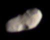
This color image provides the best look yet at Saturn's moon Calypso, a Trojan (trailing moon) of the larger moon Tethys. Calypso trails Tethys in its orbit by 60 degrees. |
|
| The content herein, unless otherwise known to be public domain, are Copyright 1995-2006 - SpaceDaily.AFP and UPI Wire Stories are copyright Agence France-Presse and United Press International. ESA PortalReports are copyright European Space Agency. All NASA sourced material is public domain. Additionalcopyrights may apply in whole or part to other bona fide parties. Advertising does not imply endorsement,agreement or approval of any opinions, statements or information provided by SpaceDaily on any Web page published or hosted by SpaceDaily. Privacy Statement |