| . |  |
. |
Washington (AFPS) Feb. 19, 2001 Nothing and no one in the military moves without NIMA, the National Imagery and Mapping Agency. Sanctioned by Congress and created by the Department of Defense on Oct. 1, 1996, NIMA is a national resource that supports everyone from the White House down to the foxhole, said Robert Zitz, director of NIMA's Initiative Group. "NIMA can be called the eyes of the nation," he said. The agency, he continued, serves three broad categories of customers: the national customer, including the national security leadership, White House and State Department; military users; and civilian users during natural disasters and humanitarian crises. Until NIMA's establishment, the CIA, Defense Intelligence Agency and military services had their own imager intelligence capabilities. The entire community was fragmented, Zitz said. The situation presented an unsolvable challenge: They couldn't share knowledge easily during joint operations, so no one had a full picture of the battle space. Operation Desert Storm drove the point home when significant problems occurred in providing information, including imagery intelligence, he said. "We weren't getting imagery to tactical commanders fast enough for them to make use of it," Zitz noted. "The mapping data wasn't as current as it needed to be." The idea behind creating NIMA was to merge capabilities in imagery intelligence, mapping, charting and geodesy into one combat support agency, and then empower it with the best information technology available, Zitz explained. They must do this while balancing the support they provide to national policy makers. The military unified commands and the military services, retained some imagery analysis and map-making capability for tactical purposes, but they and NIMA work together closely today, he said. NIMA provides terrain and topographic information for ground troops, aeronautical information for the pilots and nautical information for the sailors to move through and control their battle space. Its best-known products among troops are the paper maps they use every day during training. "There's not a soldier who doesn't rely on a map to move around," Zitz noted. "Today, we use paper maps. We collect intelligence information using imagery sources and put that out largely in a paper analog process. "But we're moving away from that paper-slow process. Military commanders ask us to give them two things: speed and accuracy. In a digital environment, we can have more speed," he said. "That's where we're moving." Another force driving NIMA's creation: The U.S. military shrank after the Cold War, he said. The forces today are more lethal and agile than before, but they are also smaller, lighter and facing a changing world environment and more complicated set of threats. "NIMA must strive for information superiority," he said. "That doesn't mean flooding commanders with data. It means putting as much meaningful, relevant information as possible into their hands in time for them to exploit it." "Think about the power of going onto a battlefield knowing not only where you and your friends are, but also knowing where the enemy is and what he's doing," he said. "It's not all in real time now, but that's the direction we're moving in. "That way you can have a smaller force structure and still be able to win decisively," he said. "We're trying to harness the power of information technology the same way we've harnessed technology for weaponry. Warfighters have gone from dumb bombs to smart bombs to brilliant bombs. We're trying to go from dropping hundreds of bombs on a target to 'one shot, one kill' scenarios. NIMA headquarters are in Bethesda, Md. The agency has major facilities in Washington, D.C.; Reston, Va., and St. Louis, Mo. Liaisons and support teams are spread out around the world. The agency objective is to use imagery -- "remote sensing" -- fused with geospatial information to provide information swiftly and accurately. It's knowing what's happening at any given point on the battlefield, and when, Zitz noted. Using a peacetime scenario, for instance, NIMA contributes to navigational safety, he said. "When a military aircraft takes off and lands safely, NIMA was there providing the mapping, charting and geospatial information to help ensure the success of the mission," he pointed out. "That's true whether it's an aircraft, ship or soldiers on the ground moving across terrain." Besides being involved with everything that moves in the military, though, there are those services to other customers. NIMA information, Zitz said, supports a full range of diplomatic activities, disaster relief operations, "no fly" zone enforcement and other countermobility missions, force protection, and humanitarian and multinational peacekeeping activities. "On a daily basis in peacetime, we support the intelligence that goes to the president, State Department, CIA and other agencies that help shape national policy," said Zitz, a former Army counterterrorism analyst and former staff member of the CIA. NIMA's cartographers, imagery analysts, physical scientists, geodesists, analysts, computer and telecommunications engineers, and photogrammetrists compile that data. NIMA is also indirectly involved with commercial traffic because of its relationship and support of the Global Positioning System, or GPS. DoD spent more than $12 billion developing the system. Today, any users -- military or civilian, domestic or foreign -- with a GPS receiver can pinpoint their location on land or sea or in the air, their velocity and local time, anytime in any weather, anywhere, Zitz explained. First-generation GPS receivers were relatively bulky and heavy. Less than 10 years later, they're the size of wireless phones -- and just as cheap. The technology, he said, is in reach of virtually everyone, and it's creeping into everything from laptops to cars, boats, airplanes, construction equipment, farm machinery and a host of military items. "Some technologists predict that not too long from now, GPS will be almost as basic as the telephone," he said. "They give thanks to forward-thinking DoD military and civilian leaders." Related Links NIMA NIMA Commission SpaceDaily Search SpaceDaily Subscribe To SpaceDaily Express Kirtland AFB - September 8, 2000 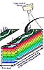 Part of a winning military strategy relies not only on smart tactical planning, but on theater commanders who can quickly collect detailed information about the battlefield. They must understand terrain -- urban and rural -- by assessing its topographical configuration and composition.
|
| ||||||||||
| The content herein, unless otherwise known to be public domain, are Copyright 1995-2016 - Space Media Network. All websites are published in Australia and are solely subject to Australian law and governed by Fair Use principals for news reporting and research purposes. AFP, UPI and IANS news wire stories are copyright Agence France-Presse, United Press International and Indo-Asia News Service. ESA news reports are copyright European Space Agency. All NASA sourced material is public domain. Additional copyrights may apply in whole or part to other bona fide parties. Advertising does not imply endorsement, agreement or approval of any opinions, statements or information provided by Space Media Network on any Web page published or hosted by Space Media Network. Privacy Statement All images and articles appearing on Space Media Network have been edited or digitally altered in some way. Any requests to remove copyright material will be acted upon in a timely and appropriate manner. Any attempt to extort money from Space Media Network will be ignored and reported to Australian Law Enforcement Agencies as a potential case of financial fraud involving the use of a telephonic carriage device or postal service. |