| . |  |
. |
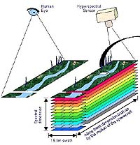
Part of a winning military strategy relies not only on smart tactical planning, but on theater commanders who can quickly collect detailed information about the battlefield. They must understand terrain -- urban and rural -- by assessing its topographical configuration and composition. They must accurately locate and identify objects upon it and discriminate between friend and foe, between landforms that will either aid or impair an operation. More than simply defining forests and rivers, or differentiating between houses and factories, today's warfighter must understand the subtle nuances of contested ground and their likely impact on mission success. He must ask questions. Is this field too muddy for a tank assault? Are breaking waves too high for an amphibious landing? What is natural foliage? What is its make-up? Are camouflaged troops or artillery pieces hidden there? Am I looking at a distant parking lot, or a grassy playground? An armored personnel carrier, or a school bus? And for such surveillance, an aerial view has always been best, whether from a hilltop or an aircraft. The higher the vantage point, the better. Now, thanks to scientists and engineers at the Air Force Research Laboratory and their recent launch of an experimental satellite, that vantage point has been raised considerably-all the way to space. "Built under contract for AFRL's Space Vehicles Directorate by the Kestrel Corporation, our MightySat II.1's hyperspectral imaging instrument is a satellite-based technology that uses hundreds of very narrow wavelength bands to "see" reflected energy from objects on the ground," said Dr. Tom Caudill of AFRL's Space Vehicles Directorate. "This energy appears in the form of "spectral fingerprints" across the light spectrum and enables us to collect much more detailed data and produce a much higher spectral resolution of a scene than possible using other remote sensing technologies. And we are the first to put this technology in space!" Once these fingerprints are detected, special algorithms -- repetitive, problem-solving mathematical calculations -- then assess them to differentiate various natural and manmade substances from one another. "Signature" libraries may also be used to identify specific materials -- e.g., rooftops, parking lots, grass, or mud-by comparing a library's pre-existing reference catalogs with freshly taken hyperspectral images of the battlefield from space. Image processing equipment then portrays the various types of terrain and objects upon it in different colors forming a "color cube," each based on the wavelength of the reflected energy captured by the image. These colors are subsequently "translated" into maps that correspond to certain types of material or objects to detect or identify military targets such as a tank or a mobile missile launcher. Algorithms can also categorize types of terrain and vegetation (useful, for example, in counter-narcotic operations), detecting features such as disturbed soil, stressed vegetation, and whether the ground will support the movement of military vehicles. Once this technology is mature, theater commanders can use mobile ground stations to process in real-time information transmitted by the satellite, critical to theater commanders for them to keep pace with rapidly changing conditions. "When all the uses of hyperspectral-imaging technology are better understood, a new, vital tool will be available to support military planning and field operations," said Space Vehicles Director Christine Anderson. "The next evolutionary step for this technology will be to integrate it with other sources of information-gathering tools, such as live video, electro-optic imagery, synthetic-aperture radar, or electronic intelligence. Then the warfighter will truly be able to see the battlefield more clearly and, at least in part, lift the 'fog of war.' "
Related Links  Greenbelt - June 1, 2000 Greenbelt - June 1, 2000NASA's investment in airborne LIDAR (light detection and ranging) mapping technology is paying major dividends in an assessment of earthquake hazards in the Puget Lowland of Washington state.
|
| ||||||||||
| The content herein, unless otherwise known to be public domain, are Copyright 1995-2016 - Space Media Network. All websites are published in Australia and are solely subject to Australian law and governed by Fair Use principals for news reporting and research purposes. AFP, UPI and IANS news wire stories are copyright Agence France-Presse, United Press International and Indo-Asia News Service. ESA news reports are copyright European Space Agency. All NASA sourced material is public domain. Additional copyrights may apply in whole or part to other bona fide parties. Advertising does not imply endorsement, agreement or approval of any opinions, statements or information provided by Space Media Network on any Web page published or hosted by Space Media Network. Privacy Statement All images and articles appearing on Space Media Network have been edited or digitally altered in some way. Any requests to remove copyright material will be acted upon in a timely and appropriate manner. Any attempt to extort money from Space Media Network will be ignored and reported to Australian Law Enforcement Agencies as a potential case of financial fraud involving the use of a telephonic carriage device or postal service. |