| . |  |
. |
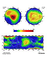
Sacramento - Dec 30, 2003 Almost from the moment of its arrival in Mars orbit, Odyssey confirmed the existence of a rich layer of near-surface ice in Mars' polar regions. Theorists had already concluded that -- since losing its original thick Noachian-age atmosphere of carbon dioxide, and the greenhouse warming which that atmosphere generated -- the now almost airless Mars has chilled down to the point that it has a "cryosphere": an upper layer kilometers thick in which any water in the surface must be frozen solid, until one gets down so deep that Mars' remaining internal geothermal warmth does allow liquid water to exist in the pores of the rock. But at the very surface of Mars, the air pressure is now so low that water ice "sublimates" -- evaporates directly into vapor. At Mars' equator, its noontime surface temperatures are now high enough that any permafrost zone (it was thought) couldn't start until much too far beneath the surface for Odyssey's instruments to detect it -- only at that depth would the peak noontime temperatures be low enough to let the ice avoid sublimating completely away into the air. But as you move toward Mars' poles, the noontime surface temperatures get colder, and so water ice can exist nearer to the surface without sublimating away. Calculations had indicated that, at about 60 degrees latitude, the near-surface was finally so cold that water ice could exist within about 80 cm of the surface -- close enough to the surface for Odyssey's instruments to detect it. (At Mars' polar caps, of course, it actually exists ON the surface.) Sure enough, Odyssey did detect near-polar water ice -- starting, with impressive accuracy, at just the latitude boundary predicted in advance. This meshed nicely with the theory that it had been deposited that close to the surface at an earlier phase of Mars' obliquity cycle, when near-surface ice at Mars' lower latitudes had sublimated into vapor, which had then drifted to the polar regions and refrozen there. (It was thought that there might be a dry gap of dozens -- or even hundreds -- of meters between this temporary atmosphere-laid deposit of near-surface ice and the main layer of permanent permafrost deeper down beneath Mars' surface.) But even these early measurements showed a problem -- the ice-rich layer, underneath its thin covering of dry soil, was TOO ice-rich. It seemed to be about 35% ice by weight, which (since rock is denser than ice) amounts to about 60% by volume. And that looked like too much ice to be deposited there just by water vapor drifting into the spaces between grains of the existing soil and freezing there -- for even the loosest soil possible has only about 50% of its volume consisting of empty spaces between grains. Now the problem has gotten worse. As Boynton said in his DPS lecture, the meter-thick shroud of frozen carbon dioxide that covered Mars' north polar region during northern winter, when Odyssey first arrived, has now evaporated with the northern summer. This has allowed Odyssey to better calibrate all its measurements of gamma rays and neutrons, by comparing its earlier observations of that northern winter CO2 snow layer with its new measurements of the underlying "residual cap" of water ice that is now naked on the surface in northern summer. And that recalibration has made it clear that Mars' near-surface polar ice layer around both poles is even more ice-rich than had been thought. Even if you assume that the ice which Odyssey is detecting extends all the way up to the surface, the layer must be about 50 to 65% ice by mass -- 73 to 85% ice by volume. And if you assume instead that the icy layer is covered with a thin layer of dry soil, it must be even more ice-rich. So that near-surface layer isn't just ice-laced dirt; it's dirt-laced ice -- and there's no possible way it could be formed by water vapor just drifting in between soil grains and freezing there. So how did it get there? Apparently in a way that is indeed linked to Mars' obliquity cycle, but in a more dramatic way than the initial simple "drifting water vapor" theory. The obliquity cycle means that when Mars' axial tilt is at its higher levels -- 35 degrees or more -- each pole will be tilted so directly toward the Sun for months at a time that it will actually get warmer than Mars' mid-latitudes, and so Mars' polar caps of surface water ice will sublimate, migrate down and refreeze at lower latitudes to form two "ice belts" at the mid-latitudes. When Mars' axial tilt occasionally rises to really high levels of 45 degrees or more -- as it last did 5.5 million years ago, according to detailed computer simulations -- these ice belts will move down to form a single ice belt running around Mars' equator! (Mars' tilt, during the planet's history, occasionally rises as high as 60 degrees -- making it join Uranus and Pluto as the third planet in the Solar System to "lie on its side" -- but the last such period must have been tens of millions of years ago.) We don't understand very well all the effects this strange state of affairs may have had on Mars' weather patterns. As Boynton said, it's possible that -- instead of water just peacefully evaporating away from the ice on some parts of Mars and refreezing in other regions during the obliquity cycle -- it may sometimes have actually formed dense clouds after evaporating into the air, and then refallen as an actual layer of snow (mixed with fairly large amounts of airborne dust) onto Mars' newly cold regions. So the cycle Boynton envisions is this: As Mars' obliquity increases and the poles start to undergo warmer summers, first the top part of the existing near-surface snow layer there sublimates away into the air, leaving behind the dust that had been mixed with it to make up the thin layer of dry surface dust that we're seeing there right now. Then, as the planet's tilt increases still further so that Mars' poles actually start to have warmer summers than its mid-latitudes do, the evaporation of the near-polar surface ice into the air increases to the degree that the rapidly increasing atmospheric water vapor forms clouds that then dump snow on the planet's lower latitudes (perhaps meters worth of snow over a period of several thousand years). Then -- as the planet's obliquity decreases again, and its lower latitudes start to warm up again -- the snow deposits that have fallen there sublimate back into the air, and refreeze again as a layer of snowfall in the re-chilling higher latitudes. And so the cycle repeats, with Mars' surface ice perpetually migrating back and forth, as snowfall, between higher and lower latitudes through the planet's history. Actually, there may be two other factors complicating the climate effects of the obliquity cycle. The gravitational tuggings of the other planets also increase and decrease the eccentricity of Mars' orbit around the Sun (which is currently mildly lopsided) over a period of about 100,000 years. And the direction in which Mars' spin axis is pointed keeps "precessing" around -- wobbling in circles as though the planet were a tilted top. Right now its south pole is tilted toward the Sun at the planet's perihelion and away from the Sun at its aphelion, so that its south pole has both considerably warmer summers and colder winters than its north pole -- but in 25,500 years the reverse will be true. These three effects, by overlapping, may cause the summer temperatures of Mars' poles to hopscotch up and down in a very irregular way, and over cycles several times shorter than 100,000 years. (Right now, for instance, Mars' northern summers are actually getting colder despite the fact that the planet's obliquity is increasing.) But the actual effects of all such latitudinal climate shifts on Mars would remain the same. Boynton also pointed out in his lecture that the newly reinterpreted Odyssey measurements now show another puzzle. The near-surface water signal from Odyssey's measurements of both gamma rays and epithermal neutrons now shows that the ice layer above about 60 degrees latitude can't possibly be buried beneath a layer of dry dirt more than only about 10-13 cm thick. (And that's if one assumes that the underlying ice is totally pure -- if it's mixed with dirt, then the dry dirt layer above it must be even thinner for Odyssey's instruments to pick up such a strong water signal.) But the data from Odyssey's measurements of the weaker thermal neutrons contradicts this, indicating that the overlying dirt layer must be a good deal thicker -- about 20-40 cm thick. The feeling is now that that original simple two-layer model of Mars' near-polar surface (dry dirt on top of a fairly pure ice layer) is too simple; there's probably a thin intermediate layer in which dirt is mixed with ice that has just frozen out of water vapor into the spaces between the soil grains -- the sort of thing that the researchers originally expected to find at Mars' high latitudes. The analyses to see how well this new "three-layer" model matches Odyssey's measurements aren't done yet. But this would also explain why the edges of that near-polar ice mantle which is close enough to the surface to be detectable by Odyssey exactly match the edges that had been predicted from the original simple "frozen inter-grain water vapor" model -- which is hard to explain if the ice that Odyssey is detecting comes entirely from snowfall instead.
|
| ||||||||||
| The content herein, unless otherwise known to be public domain, are Copyright 1995-2016 - Space Media Network. All websites are published in Australia and are solely subject to Australian law and governed by Fair Use principals for news reporting and research purposes. AFP, UPI and IANS news wire stories are copyright Agence France-Presse, United Press International and Indo-Asia News Service. ESA news reports are copyright European Space Agency. All NASA sourced material is public domain. Additional copyrights may apply in whole or part to other bona fide parties. Advertising does not imply endorsement, agreement or approval of any opinions, statements or information provided by Space Media Network on any Web page published or hosted by Space Media Network. Privacy Statement All images and articles appearing on Space Media Network have been edited or digitally altered in some way. Any requests to remove copyright material will be acted upon in a timely and appropriate manner. Any attempt to extort money from Space Media Network will be ignored and reported to Australian Law Enforcement Agencies as a potential case of financial fraud involving the use of a telephonic carriage device or postal service. |