| . |  |
. |
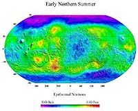
Sacramento - Dec 30, 2003 At any rate, a lot of additional geological evidence is now turning up for the idea that large amounts of ice have migrated back and forth between Mars' higher and lower latitudes as its axial tilt keeps changing. Mars' surface above 60 degrees latitude is quite smooth with mild bumps on it, as one would expect from a near-surface permafrost layer. But between 60 and 30 degree latitudes, this smooth mantle is "dissected" -- that is, it exists only in scattered scraps across the Martian surface. This is just what one would expect if a similar near-surface ice layer had been deposited at these lower latitudes during a Martian high-obliquity period, and then the near-surface ice had completely evaporated away as the obliquity dropped and the lower latitudes warmed up again, leaving behind a crust of soil weakly cemented together by salts that had been dissolved in the ice. That crust was then gradually eroded away from the surface by Mars' winds, except in patches. Some of these patches show signs of layering, as though the mantle's deposition and removal has indeed taken place in repeated cycles. And a different form of layering can be found in the "layered deposits" found immediately around the edges of both current polar caps, which consist of dust and ice mixed together in different ratios within clearly separate layers. These deposits were, in fact the very first clue to the climate effects of Mars' obliquity cycles -- the southern layered deposits were the target for the unsuccessful Mars Polar Lander. They seem to be made of mixed ice and dust that have migrated all the way to the edges of the poles, in different dust-to-ice ratios at different times due to the obliquity-generated climate changes. Back in the 60 to 30 degree latitude zone, other signs can be seen that near-surface ice has existed there at some time but then disappeared. "Viscous creep" features are often seen in the same latitude zone -- areas where Mars' surface material has apparently flowed downhill, as though they were very slow-moving glaciers. And the slopes of features in general at these latitudes tend to be shallower, as though a similar force had led to such downhill creep all over the zone. Another feature concentrated in this latitude zone are the mysterious "gullies", discovered by Mars Global Surveyor, that have attracted such attention -- several hundred meters long, running down from "alcoves" at the upper parts of some crater and valley slopes from which liquid water seems to have flowed only a short time ago. The estimated age for the gullies found thus far is somewhere between 20 years and a million years -- but none of them seems to be active right now. It's logical to think that they too are the result of the obliquity-linked temperature cycles, and THEMIS investigator Phil Christensen thinks that they too are the result of cycle-related snowfalls in these latitudes. In his view, the fallen snow accumulates in depressions and pockets on the slopes where the temperature is particularly low -- and then, when the obliquity cycle starts to raise the temperature of that latitude again, the snow melts and runs down the slope, enlarging the alcoves where it first accumulated and also plowing gullies down the slope beneath. Then, as the temperature rises still further, the snow and the refrozen meltwater ice sublimate back into the air as vapor, leaving the gullies and alcoves exposed. This would happen during repeated obliquity cycles to gradually carve the gully deeper -- a tiny version of the repeated water flows from far bigger melted snowpacks that (acording to Michael Carr) may have carved Mars' valley networks during its dense-atmosphere Noachian days. But there are problems with this theory for the gullies. They tend to flow entirely from next to a single layer of rock or compacted soil just a few hundred meters from the top of a particular slope -- whereas, if they result from accumulated pockets of snow, those pockets would tend to build up at all sorts of different heights up and down the slope. And they sometimes flow in dramatic numbers from one slope of a crater or valley, while not flowing at all from another such slope only a few dozen km away and facing the same direction -- although the two slopes would have undergone exactly the same kind of weather conditions. As Jennifer Heldmann of Ames Research Center pointed out in her poster at the DPS meeting, this strongly suggests that the water for the gullies has actually erupted from a subsurface layer of liquid water (an "aquifer") which has been kept liquid by local geothermal warmth in that region, and whose side edge has been exposed on a slope. Such underground pockets of liquid water are limited in their horizontal size, which would explain why the gullies often erupt from one slope but not another nearby one. But this still leaves it likely that they are linked to the temperature changes of the obliquity cycle. It seems likely that the liquid water erupts from the slope surface either during when the slope is at its warmest point during the obliquity cycle -- and the ice plug sealing off the liquid aquifer's edge from the colder outer surface of the slope sublimates away into the atmosphere, freeing the liquid water behind it to gush out onto the slope -- or during the COLDEST part of the obliquity cycle, when the underground water layer starts to freeze and expand from the top down, placing great pressure on the remaining liquid water until it blows out the narrower side ice-plug leading onto the slope. (Indeed, the second cause may be more common.) And this idea takes us to an alternative theory of how the temperature changes caused by Mars' obliquity cycles could create the near-surface layer of relatively pure ice detected near the near-polar surface by Odyssey. Instead of being the remains of periodic snowfalls from above, it may be liquid water that was actually pumped up from UNDERNEATH by hydraulic processes associated with the obliquity cycle's temperature changes, and concentrated in a near-surface layer which then refroze into ice. Aaron Zent of Ames Research Center proposed the possibility that Mars' near-surface frozen ice layer is an "ice lens", which forms when the temperature at the top of a near-surface layer of soil that's laced with some liquid water drops so that an very thin ice layer starts to form at the surface -- after which surface-tension effects between the bottom surface of the ice layer and the liquid water underneath it draw more and more liquid water upwards through the soil, like a wick, to freeze onto the bottom surface of the ice, shoving soil particles aside in the process to produce a steadily thickening near-surface layer (a "lens") of almost pure ice. This effect, on Earth, can produce "frost heaves" capable of buckling a road surface -- and it's actually more effective in fine-grained soil that's only moist rather than water-saturated: the sort of thing one would be most likely to find in relatively warm near-surface Martian soil. If this, rather than snowfall layers, is the cause of Mars' near-surface polar ice layer, it would explain why Mars' slope gullies don't seem to be in the right place on their slopes to have been formed by any snowfall patches.
|
| ||||||||||
| The content herein, unless otherwise known to be public domain, are Copyright 1995-2016 - Space Media Network. All websites are published in Australia and are solely subject to Australian law and governed by Fair Use principals for news reporting and research purposes. AFP, UPI and IANS news wire stories are copyright Agence France-Presse, United Press International and Indo-Asia News Service. ESA news reports are copyright European Space Agency. All NASA sourced material is public domain. Additional copyrights may apply in whole or part to other bona fide parties. Advertising does not imply endorsement, agreement or approval of any opinions, statements or information provided by Space Media Network on any Web page published or hosted by Space Media Network. Privacy Statement All images and articles appearing on Space Media Network have been edited or digitally altered in some way. Any requests to remove copyright material will be acted upon in a timely and appropriate manner. Any attempt to extort money from Space Media Network will be ignored and reported to Australian Law Enforcement Agencies as a potential case of financial fraud involving the use of a telephonic carriage device or postal service. |