| . |  |
. |
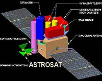
THEOS will provide Thailand with worldwide geo-referenced image products and image processing capabilities for applications in cartography, land use, agricultural monitoring, forestry management, coastal zone monitoring and flood risk management - providing access to any part of Thailand in less than 2 days. The Theos contract includes the production and launch of one optical satellite, as well as the development of the ground segment necessary to operate and control the satellite directly from Thailand. This is naturally accompanied by state of the art facilities for image archiving and processing. The Theos satellite is based on the new generation of EADS Astrium Optical Earth Observation high performance satellites, the AstroSat product line, and benefits from EADS Astrium's extensive experience in this field which started with the SPOT and METOP satellites. As part of the Theos contract, Thai engineers will join the EADS Astrium development team and will attend intensive space programme training. This cooperation contract paves the way for further development of GISTDA and space activities in Thailand. The Theos satellite payload features both high resolution in panchromatic mode and wide field of view in multispectral mode and has been tailored to Thailand's specific needs with a worldwide imaging capability. It will be launched mid 2007 on a sun synchronous orbit at an altitude of about 820km. This is a major achievement and the third export cooperation contract in the field of Earth observation signed by EADS Astrium in Asia after the ROCSAT-2 satellite, built for the Republic of China, successfully launched in May 2004 and the KOMPSAT-2 satellite for Korea.
Related Links EADS Astrium SpaceDaily Search SpaceDaily Subscribe To SpaceDaily Express 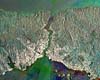 Paris (ESA) Jun 28, 2005
The city of Istanbul, located astride the eastern edge of Europe and western edge of the Asian continent, shown in an Envisat radar multi-temporal composite image.
|
| ||||||||||
| The content herein, unless otherwise known to be public domain, are Copyright 1995-2016 - Space Media Network. All websites are published in Australia and are solely subject to Australian law and governed by Fair Use principals for news reporting and research purposes. AFP, UPI and IANS news wire stories are copyright Agence France-Presse, United Press International and Indo-Asia News Service. ESA news reports are copyright European Space Agency. All NASA sourced material is public domain. Additional copyrights may apply in whole or part to other bona fide parties. Advertising does not imply endorsement, agreement or approval of any opinions, statements or information provided by Space Media Network on any Web page published or hosted by Space Media Network. Privacy Statement All images and articles appearing on Space Media Network have been edited or digitally altered in some way. Any requests to remove copyright material will be acted upon in a timely and appropriate manner. Any attempt to extort money from Space Media Network will be ignored and reported to Australian Law Enforcement Agencies as a potential case of financial fraud involving the use of a telephonic carriage device or postal service. |