| . |  |
. |
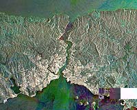
The city of Istanbul, located astride the eastern edge of Europe and western edge of the Asian continent, shown in an Envisat radar multi-temporal composite image. What is today Europe's third largest urban centre has been a major city for the last two thousand years. It has known three different names in that time: Byzantium when it was the gateway to Greek settlements on the Black Sea, Constantinople when it became the capital of the Eastern Roman Empire, then Istanbul when it fell to Muslim invaders in 1453. In 1919 Istanbul lost its position as capital of Turkey, but remains that country's leading economic centre. Its population has grown from 2.84 million in 1970 to around ten million today, with settlers flocking from rural areas of Anatolia. Around 30% of all the cars owned in Turkey are in Istanbul. Urban areas show up as white in this image � the brightest areas being the most densely built-up. Among the densest is the old town, located on the west side of the city on the Emin�nu Peninsula, below the river estuary known as the Golden Horn. Further west along the coast are the runways of Ataturk International Airport. Istanbul owes its prosperity to its status as a link between the Balkans, the Middle East and Central Asia, and to the high level of shipping that travels through the narrow Bosporus (Bosphorus) channel dividing Europe and Asia. Some 48 000 ships pass through the Bosporus annually, three times denser than the Suez Canal traffic and four times as dense as the Panama Canal. Around 55 million tonnes of oil are shipped through here each year. Look closely along the Bosporus and bright points from individual ships can be seen. Also visible are the two bridges connecting the two continents, crossed by at least 45 000 vehicles daily. Note the chain of islands known as the Princes' Islands (Kizil Islands) off the east side of Istanbul. The city faces onto the inland Sea of Marmara (Marmara Denizi), which has an area of around 11 350 square kilometres. The Bosporus links the Sea to the Black Sea. Note also Lake Iznik (Iznik Golu) towards the south-east corner of the image. Because radar images measure surface texture rather than reflected light, there is no colour in a standard radar image. Instead the colour in this image is due to it being a multitemporal composite, made up of three Advanced Synthetic Aperture Radar (ASAR) images acquired on different dates, with separate colours assigned to each acquisition to highlight differences between them: Red for 31 July 2003, Green for 17 April 2003 and blue for 26 February 2004. The view was acquired in ASAR Image Mode Precision, with pixel sampling of 12.5 metres. Related Links SpaceDaily Search SpaceDaily Subscribe To SpaceDaily Express  Dulles VA (SPX) Jun 30, 2005
Orbimage Holdings announced Wednesday that its subsidiary Orbimage signed an agreement with Microsoft to supply high resolution global satellite image data for MSN Virtual Earth, a key component of MSN Search.
|
| ||||||||||
| The content herein, unless otherwise known to be public domain, are Copyright 1995-2016 - Space Media Network. All websites are published in Australia and are solely subject to Australian law and governed by Fair Use principals for news reporting and research purposes. AFP, UPI and IANS news wire stories are copyright Agence France-Presse, United Press International and Indo-Asia News Service. ESA news reports are copyright European Space Agency. All NASA sourced material is public domain. Additional copyrights may apply in whole or part to other bona fide parties. Advertising does not imply endorsement, agreement or approval of any opinions, statements or information provided by Space Media Network on any Web page published or hosted by Space Media Network. Privacy Statement All images and articles appearing on Space Media Network have been edited or digitally altered in some way. Any requests to remove copyright material will be acted upon in a timely and appropriate manner. Any attempt to extort money from Space Media Network will be ignored and reported to Australian Law Enforcement Agencies as a potential case of financial fraud involving the use of a telephonic carriage device or postal service. |