| . |  |
. |
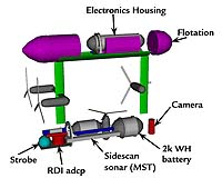
Deepwater coral reefs in the US Virgin Islands may occupy a much larger area and be in better health than previously thought, based on evidence gathered by a new autonomous underwater vehicle which flies through the sea like a helicopter. Scientists and engineers used an autonomous underwater vehicle and imaging platform called SeaBED during a first-of-its-kind study to determine the health of deepwater coral reefs and related spawning areas for commercial fisheries. While recent reports indicate shallow reefs in the Caribbean and around the world are threatened, this new study found well-developed deeper water coral reefs with nearly 100 percent living coral cover, highly unusual in the Caribbean where disease, pollution, land run-off and other factors have caused widespread coral mortality in shallower reefs in the past few decades. Until now, little information was available on the structure and composition of the deeper coral reefs due to the depths of these insular shelf reefs, which are beyond the safe range of SCUBA diving at 90 to 200 feet deep and some 10 miles from land. Two reef areas, the Marine Conservation District Hind Bank and the South Drop, were surveyed in June south of St. Thomas and St. John in the US Virgin Islands by Woods Hole Oceanographic Institution (WHOI) scientist Hanumant Singh, graduate students Chris Roman and Ryan Eustice, and postdoctoral investigator Ali Can in collaboration with Roy Armstrong of the University of Puerto Rico and observer Liane Guild of NASA Ames Research Center. Scientists from the University of the Virgin Islands (USVI), the Department of Planning and Natural Resources of the USVI, and the Caribbean Fishery Management Council (CFMC) also assisted with the study. The project was funded by the National Science Foundation with additional support from the National Oceanic and Atmospheric Administration (NOAA) and CFMC, which is responsible for protecting marine habitats in waters beyond three nautical miles from shore. The team used SeaBED, developed by Singh and his WHOI colleagues, to take a series of 7,000 digital still images of the coral reef habitats. SeaBED conducted nine successful missions at night, when it is easier to image the reefs using strobe lights, on the Marine Conservation District Hind Bank near St. Thomas and the South Drop near St. John. Both reefs are 30 to 80 meters (90 to 265 feet) below the surface, deeper than normally reachable by divers. The vehicle "flew" seven lines, or transects, each several miles long over the banks, collecting color images every three seconds during the week-long project. The banks had never been mapped or imaged before, so the diversity and abundance of coral species and the health of the corals was a major surprise. Hind Bank Marine Conservation District (MCD), the first no-take fishery conservation zone in US federal waters, had been a key commercial fishing ground for years. On the recommendation of fishers, scientists and government officials the MCD was closed to fishing and to the taking of coral in 1999 to protect both the reef and the related fishery. Red hind, a type of grouper, is one of the most valuable commercial fisheries in the Caribbean and is still fished in other areas. Seasonal closings in the Caribbean are common to help protect the fisheries, and studies by Rick Nemeth of the University of the Virgin Islands indicate that the size and the quantity of fish in the closed areas on the banks are increasing. Graciela Garcia-Moliner of the CFMC scientific staff said the management council did not know what kind of corals were present or what kind of fish spawned on the reefs other than grouper because so little information has been available. "Until this survey, we did not know what kind of corals we have, how healthy they are, how deep the reefs extend or how large the reefs actually are and what marine life lives there because no one had ever seen them. "We had only nautical charts of the area, but no maps or images. SeaBED has opened a whole new world to us, and we are surprised at how healthy and abundant the corals are." Garcia-Moliner says only a fraction of the deep water reefs has been mapped and imaged since SeaBED spent only a week there. Most corals that need light to survive do not grow at depths greater than 90 meters (300 feet), so much of it may be in intermediate water depths, beyond the range of most divers and too risky for remotely operated or tethered vehicles to work in due to the risk of getting their cables snagged on the rugged terrain. Singh said SeaBED is a perfect tool for this type of project because it is inexpensive to operate, can be deployed from a small boat and operated by one or two people, and can follow the rugged terrain of a coral reef and work to depths of 500 meters (about 1,500 feet). The recent study was conducted aboard the Research Vessel Chapman from the University of Puerto Rico. Singh and the Woods Hole Oceanographic team plan to return to the reefs with SeaBED in October 2004. New sensors may be added and the survey area expanded. Annual surveys are now planned to determine changes over time in the health of the reef and its inhabitants. Related Links Woods Hole Oceanographic Institution SeaBED home page Fisheries Management Council National Science Foundation SpaceDaily Search SpaceDaily Subscribe To SpaceDaily Express  Pasadena - Jul 24, 2003
Take one well-seasoned oceanography satellite, the joint NASA-CNES (French Space Agency) Topex/Poseidon, nearing its 11th year in orbit to study the world's ocean circulation and its effect on climate, mix in a fresh sibling satellite, Jason, and add a dash of ingenuity, and you get what scientists are calling the Jason-Topex/Poseidon tandem mission.
|
| ||||||||||
| The content herein, unless otherwise known to be public domain, are Copyright 1995-2016 - Space Media Network. All websites are published in Australia and are solely subject to Australian law and governed by Fair Use principals for news reporting and research purposes. AFP, UPI and IANS news wire stories are copyright Agence France-Presse, United Press International and Indo-Asia News Service. ESA news reports are copyright European Space Agency. All NASA sourced material is public domain. Additional copyrights may apply in whole or part to other bona fide parties. Advertising does not imply endorsement, agreement or approval of any opinions, statements or information provided by Space Media Network on any Web page published or hosted by Space Media Network. Privacy Statement All images and articles appearing on Space Media Network have been edited or digitally altered in some way. Any requests to remove copyright material will be acted upon in a timely and appropriate manner. Any attempt to extort money from Space Media Network will be ignored and reported to Australian Law Enforcement Agencies as a potential case of financial fraud involving the use of a telephonic carriage device or postal service. |