| . |  |
. |
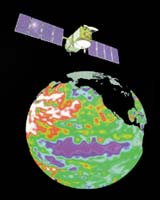
Take one well-seasoned oceanography satellite, the joint NASA-CNES (French Space Agency) Topex/Poseidon, nearing its 11th year in orbit to study the world's ocean circulation and its effect on climate, mix in a fresh sibling satellite, Jason, and add a dash of ingenuity, and you get what scientists are calling the Jason-Topex/Poseidon tandem mission. Since last September, when the older spacecraft was maneuvered into a tightly spaced orbit with Jason's, the two have engaged in a spicy experimental orbital tango. The spacecraft is serving up exceptionally high-resolution data on the height of the world's ocean surfaces, a key measure of heat storage in the ocean, that influences weather and future planetary climate events. The experimental tandem mission data will help scientists better detect and understand ocean currents, tides and eddies. In a paper in the American Geophysical Union newsletter Eos, Dr. Lee-Lueng Fu, project scientist for the Jason and Topex/Poseidon missions at JPL, reports the mission is producing ocean surface topography data that reveal twice as many details as seen before. "The Jason-Topex/Poseidon tandem mission doubles the resolution of ocean surface topography data, creating a continuous, simultaneous record of superior-quality radar measurements that will be used to map ocean surface current speed and direction revealing important new information about these energetic swirls that are often too small to be resolved by a single satellite," Fu said. "Tandem mission data will allow scientists to revise ocean models, improving their ability to predict ocean currents in the future," he said. Fu said data from the mission is expected to improve our knowledge of ocean tides in coastal and other shallow-water regions, the changing transports of boundary currents, the horizontal transport of heat in the oceans and other climate- relevant properties. Also, it may validate theories of ocean turbulence caused by the Coriolis force, a phenomenon caused by Earth's rotation that deflects moving objects, such as water or air, to the right in the northern hemisphere and to the left in the southern hemisphere. The data may provide valuable information about ocean eddies, a type of ocean "weather." These intermediate-sized (30 to 120 miles across), ocean features generally last only a few months, yet play an important role in transporting ocean heat. Eddies help create ocean weather patterns and transport nutrients from deep to shallower waters, where they enhance the growth of marine life. Beyond Jason and the tandem mission, scientists are developing ways to achieve even higher resolution ocean measurements without flying multiple conventional altimeters. A Jason follow-on project, the Ocean Surface Topography Mission, may carry a Wide-Swath Ocean Altimeter. It would make wide-swath ocean surface height measurements using radar interferometry. The wide-swath instrument would provide a resolution of about nine miles on the ocean surface, an eight-fold improvement in data resolution over the tandem mission. With Jason's instruments fully calibrated, NASA and CNES released via the Internet Jason's first high accuracy science data products. The products represent the final, validated records of Jason altimetry data and associated background information. Scientists around the world will use these records to develop products and perform investigations. The Jason science team has accumulated approximately 50, 10-day cycles from the mission. These will be reprocessed over the next several months to create a single data record for each cycle. Future records will be made available to the public about 35 days after spacecraft collection. Specialized products are available to scientists. Jason is continuing Topex/Poseidon's observations of ocean surface topography, monitoring world ocean circulation, studying interactions of the oceans and atmosphere, improving climate predictions and observing events like El Nino. Jason's onboard altimeter precisely maps the surface height of 95 percent of Earth's ice-free oceans every 10 days to an accuracy of about 1.33 inches. The spacecraft provides continuous data on wind speed and wave height. Related Links Sealevel Data at JPL Jason Data Products SpaceDaily Search SpaceDaily Subscribe To SpaceDaily Express 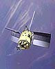 Paris (ESA) Jul 18, 2003
Today the International Charter on Space and Major Disasters gained a major new signatory in a ceremony at ESA Headquarters in Paris. Rafael Bielsa, Minister of Foreign Affairs of the Republic of Argentina and Chairman of the Board overseeing Argentina's Comisi�n Nacional de Actividades Espaciales (CONAE) signed up to the Charter in the presence of ESA Director General Jean-Jacques Dordain, ESA Director of Earth Observation Jos� Achache and CNES Director of International Relations Serge Plattard.
|
| ||||||||||
| The content herein, unless otherwise known to be public domain, are Copyright 1995-2016 - Space Media Network. All websites are published in Australia and are solely subject to Australian law and governed by Fair Use principals for news reporting and research purposes. AFP, UPI and IANS news wire stories are copyright Agence France-Presse, United Press International and Indo-Asia News Service. ESA news reports are copyright European Space Agency. All NASA sourced material is public domain. Additional copyrights may apply in whole or part to other bona fide parties. Advertising does not imply endorsement, agreement or approval of any opinions, statements or information provided by Space Media Network on any Web page published or hosted by Space Media Network. Privacy Statement All images and articles appearing on Space Media Network have been edited or digitally altered in some way. Any requests to remove copyright material will be acted upon in a timely and appropriate manner. Any attempt to extort money from Space Media Network will be ignored and reported to Australian Law Enforcement Agencies as a potential case of financial fraud involving the use of a telephonic carriage device or postal service. |