| . |  |
. |
The recent tragedy striking the coastlines of the Indian Ocean has highlighted the benefits of international cooperation in Earth Observation for the management of disaster relief, while demonstrating the scope for improved cooperation in the future.
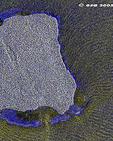
International Charter on Space and Major Disasters Immediately after the first tsunami struck in the Eastern Indian Ocean the International Charter on Space and Major Disasters was invoked by three different agencies. India activated the Charter for access to data over its own territory, the UN Office of Outer Space Affairs activated in relation to Indonesia and Thailand while the French Civil Protection Agency opened the Charter for the case of Sri Lanka. The Charter was implemented in 2000 to ensure the ready and immediate access to Earth Observation data from participating space agencies by those dealing with major disasters. As a result, data have been acquired from many satellite sources since immediately after the event, including ESA's Envisat, ERS and Proba satellites, the French SPOT series, Canada's Radarsat, the USGS Landsat and India's IRS series together with very high resolution data from the IKONOS and Quickbird series supported through the German Space Agency DLR and NASA respectively. Satellite data from before the disaster have also made a major contribution by providing a historical analysis baseline. All data have given to the relief agencies in the field, with higher-level derived information being developed and made available by image processing and value-adding agencies. The main benefit of the data has been to allow an immediate assessment of the extent of the damage in those areas where local information is either impossible or difficult to access, and to give a more general overview of the affected areas. Many different agencies have been involved: for a complete list, together with examples of data and information products, visit the ESA Earthwatching website (see right navigation bar link). But the disaster has also shown the need for improved in-situ data from floating buoys and from bottom pressure sensors, such as those available in the Pacific Ocean. It has also shown the need for improved communications between agencies: the Pacific tsunami warning system was able to detect that an earthquake had taken place in the Indian Ocean, not affecting significantly the Pacific, but the lack of communications between the various geographical regions, together with the lack of local preparedness and contingency planning, meant that full use of this information was not made. This could perhaps have saved many tens of thousands of lives, as only a modest response by those living close to the affected shorelines would have been crucial.
Towards a Global Earth Observing System of Systems (GEOSS) In July 2003 the first summit of nations and organisations involved in Earth Observation was held in Washington DC, hosted by Secretary of State Colin Powell. It marked a first step in putting in place a global system of systems for improved coordination of observations of the Earth, whether from satellites or ground-based, oceanographic and atmospheric in-situ sensors. Summit participants launched the intergovernmental ad hoc Group on Earth Observations (GEO) to set up a ten-year implementation plan for the development of such a system of systems. A second Earth Observation Summit hosted in April 2004 in Tokyo by Prime Minister Junichiro Koizumi furthered the process and it is expected that the third Summit, scheduled for 16 February 2005 and hosted by the European Commission (EC) in Brussels will adopt the plan and authorise its implementation. These recent tragic events have shown the important benefits that could be derived from a successful implementation of the GEO plan.
Global Monitoring for Environment and Security (GMES) The primary European contribution to the Global Earth Observation System of Systems is the Global Monitoring for Environment and Security (GMES) initiative. Jointly led by the EC and ESA, this initiative will bring together the capacity of Europe to collect and manage data and information on the environment and civil security, for the benefit of the European citizen. This European capacity is composed of three modules, which together constitute the functional GMES 'system':
Many elements of the modules already exist but have been conceived, designed and managed in isolation, limiting interoperability and production of relevant information. The coherence, efficiency and sustainability of a shared information system for Europe will be the added value of GMES. Proposals for the next phase of GMES, including the development of an operational series of Earth Observation satellites building on the European experience, will be made to ESA and EC Ministers in 2006.
Respond UNOSAT Group on Earth Observations SpaceDaily Search SpaceDaily Subscribe To SpaceDaily Express 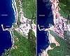 Paris, France (SPX) Jan 04, 2005
Satellites are playing a key role in helping rescue and reconstruction efforts in the Indian Ocean, beaming down images from space of areas worst-affected by the earthquake and tidal waves.
|
| ||||||||||
| The content herein, unless otherwise known to be public domain, are Copyright 1995-2016 - Space Media Network. All websites are published in Australia and are solely subject to Australian law and governed by Fair Use principals for news reporting and research purposes. AFP, UPI and IANS news wire stories are copyright Agence France-Presse, United Press International and Indo-Asia News Service. ESA news reports are copyright European Space Agency. All NASA sourced material is public domain. Additional copyrights may apply in whole or part to other bona fide parties. Advertising does not imply endorsement, agreement or approval of any opinions, statements or information provided by Space Media Network on any Web page published or hosted by Space Media Network. Privacy Statement All images and articles appearing on Space Media Network have been edited or digitally altered in some way. Any requests to remove copyright material will be acted upon in a timely and appropriate manner. Any attempt to extort money from Space Media Network will be ignored and reported to Australian Law Enforcement Agencies as a potential case of financial fraud involving the use of a telephonic carriage device or postal service. |