| . |  |
. |
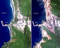
Paris, France (SPX) Jan 04, 2005 Satellites are playing a key role in helping rescue and reconstruction efforts in the Indian Ocean, beaming down images from space of areas worst-affected by the earthquake and tidal waves. "What the logistical teams want are the most up-to-date maps possible of the area, to be able to work on the ground, protect people and try to find free areas to set up makeshift camps as well as to know which roads can be used and which ones are blocked," said Eliane Cubero of France's national space study centre, the CNES. As soon as the tidal waves hit on December 26, after a massive earthquake off Indonesia, an international space agencies charter on dealing with natural catastrophes, was put into operation at the request of organisations such as the United Nations, seeking images of what was happening on the ground. "Given the size of the phenomenon we had to take action in several countries at once," said Cubero at the Toulouse-based centre, adding the affected region was divided into three zones, India, Indonesia and Sri Lanka. She was put in charge of coordinating the programmes using the satellite Spot 5 and 4, India's IRS, Canada's Radarsat and Envisat from the European Space Agency. Jean-Claude Favard, coordinating images of Sri Lanka at the CNES, said the data from the Radarsat was being analysed by the Canadians, then handled by a specialist company in Strasbourg called SERTIT. The company was comparing archive images of stricken areas with the new images to see what had changed, and that information was then compiled and transmitted to teams on the ground. This allowed them to see the extent of the damage as well as determine which areas remained flooded, thus providing a comprehensive map of the area, said Favard, an expert in evaluating satellite images of Earth. A French technical engineering group, Geosciences Consultants (GSC), has also volunteered its expertise to non-governmental organisations providing maps of the devastated areas. "We have a data-base of world maps which allows us to work out quickly the spread of disasters, as well as a data-base of all infrastructures (such as airports, populated areas, harbours) which can give us a swift idea of what might have been affected," said GSC director, Richard Guillande. GSC has been putting together fresh maps of Myanmar "where it is believed the loss of life is being downplayed." "We want to verify through images from space if we can see zones which have been more badly affected then the Burmese government is admitting," he said. Yangon has put the tsunami toll at 53 killed and 21 missing, but a previous UN toll spoke of at least 90 dead on December 28. Satellites images are also useful for long-term reconstruction, Guillande said. They can allow aid organisations "to know which areas are still affected by polluted sea waters so should not be cultivated, and where fresh water supplies can still be found."
NGA Assisting U.S. Agencies in Tsunami Disaster Assessment NGA is providing imagery products of the affected areas on a daily basis to: the U.S. Agency for International Development's Office of Foreign Disaster Assistance (OFDA); the U.S. Pacific Command (USPACOM), in whose region the tsunami occurred; and to other U.S. government agencies supporting humanitarian relief activities. NGA continues to use its commercial satellite imagery contracts to fulfill customer requests for information. The products show the scope of the damage caused by the earthquake and resulting tsunami. OFDA and USPACOM are using the products to determine the priorities for emergency relief efforts and where life supporting supplies and personnel need to be deployed. NGA is also assessing impacts to infrastructure, which includes damage to roads, bridges, ports, and airfields and how that damage affects access in and out of the damaged areas. This assessment will assist the U.S. Transportation Command (USTRANSCOM) and others providing assistance in the region.
Orbimage Increases Image Collection of Tsunami Areas In support of US Government relief efforts and research on the deadly phenomenon, Orbimage has been providing daily updates to Government officials and aid organizations on all relevant imagery collected by its high-resolution imaging satellite after the tsunamis struck, as well as imagery from before the events, which is important for comparison. Examples of some of the OrbView-3 satellite imagery of the affected areas can be seen on Orbimage's web site. "I think everyone is deeply concerned for the welfare of everyone affected by this tragic event," said Matt O'Connell, Orbimage's CEO. "To support the relief efforts of the US Government, and other international agencies, we're doing our part by allocating every available orbit we have to collecting imagery over the damaged areas. Since the affected area is so large, satellite imagery is an important tool for evaluating, measuring and mapping the extent of the tsunamis' destruction." Since the tsunamis hit on Sunday, December 26th, Orbimage has collected approximately 19,000 square kilometers of imagery over Indonesia, India, Sri Lanka and Thailand and will continue collecting daily for the next several weeks.
International Charter on Space and Major Disasters Current members of the International Charter on Space and Major Disasters include ESA Member States, Argentina, Canada, India, Japan and the USA. Civil protection authorities from other countries can also submit requests by contacting their partner organisations through existing cooperation mechanisms to help them in the major relief efforts that are now underway.
Consolidated Imagery Tsunami Imagery at Orbimage
SpaceDaily 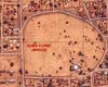 Strasbourg, France (ESA) Dec 07, 2004
It is hard to overstate the scale of the humanitarian emergency unfolding in Sudan's strife-torn Darfur region: by current estimates there are 1.45 million people displaced from their homes across an area the size of France. However, images from space are assisting aid workers as they cope with the crisis.
|
| ||||||||||
| The content herein, unless otherwise known to be public domain, are Copyright 1995-2016 - Space Media Network. All websites are published in Australia and are solely subject to Australian law and governed by Fair Use principals for news reporting and research purposes. AFP, UPI and IANS news wire stories are copyright Agence France-Presse, United Press International and Indo-Asia News Service. ESA news reports are copyright European Space Agency. All NASA sourced material is public domain. Additional copyrights may apply in whole or part to other bona fide parties. Advertising does not imply endorsement, agreement or approval of any opinions, statements or information provided by Space Media Network on any Web page published or hosted by Space Media Network. Privacy Statement All images and articles appearing on Space Media Network have been edited or digitally altered in some way. Any requests to remove copyright material will be acted upon in a timely and appropriate manner. Any attempt to extort money from Space Media Network will be ignored and reported to Australian Law Enforcement Agencies as a potential case of financial fraud involving the use of a telephonic carriage device or postal service. |