| . |  |
. |
| . | |
. |
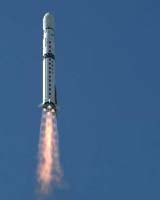
China successfully placed a new Earth observing satellite into orbit on Sunday (Oct. 27). With the launch of Ziyuan-2B (ZY-2B, "Ziyuan" means resource), China now has three Ziyuan remote sensing satellites to monitor changing conditions of the Earth's surface. A 45-meter tall Changzheng-4B (Long March-4B) rocket, with a liftoff mass of 250 tonnes, blasted off from the Taiyuan Satellite Launching Center (TSLC) in the northern Shanxi Province at 11:17 a.m. Beijing Time (0317 UTC), Xinhua News Agency reported. China News Services said that the Xi'an Satellite Control Centre (XSCC) in the central Shaanxi Province confirmed the ZY-2B separation from the launcher about 12 minutes after launch. XSCC reports that ZY-2B has been performing nominally after reaching orbit. Xinhua called the launch "a generous gift that our nation's aerospace technology workers present to the upcoming 16th National Congress of the Communist Party of China (CPC)." The 16th CPC National Congress will be held in Beijing on Nov. 8. The launch was the fifth flight of CZ-4B, which held a perfect launch record since it entered service with the inaugural launch in May 1999. The flight was also the 26th successful launch of Changzheng rockets since October 1996. Reportedly an injury on the ground due to launcher debris, however, tarnished the successful liftoff. Chinese Business View, a daily newspaper in the Shaanxi Province, reported that residents of the Yanghe village in the city of Shangluo heard an explosion in the sky minutes after the CZ-4B launch. Residents then saw metallic debris rained down within a radius of about 10 km. Shangluo is a city in the southeast corner of the Shaanxi Province and some 600 km southwest of the launch site in the neighbouring province. The investigation team consisting of local law enforcement officials and leaders in the village found 19 pieces of debris that was part of the CZ-4B launcher. The newspaper also reported that a nine-year-old boy suffered an injury to his left toe from the rocket debris. The youngster received medical treatment in a local hospital. ZY-2B is in a sun-synchronous polar orbit of 470 x 483 km, with an inclination of 97.4 degrees and a period of 94.1 minutes. According to Xinhua, ZY-2B will be used in earth resources surveying, environment monitoring and its protection, city planning, crops yield estimate, disaster prevention and mitigation, and space science testing. Specialists at XSCC said that ZY-2B would remain operational "for a few years". The mission of ZY-2B is similar to its predecessor ZY-2A, which went into space in September 2000. Both ZY-2 satellites are in a distinct series from the ZY-1 series of EO satellites. The ZY-1A remote sensing satellite is a collaborative project between China and the Brazilian space agency INPE. Thus the satellite also goes by the name China-Brazil Earth Resources Satellite-1 (CBERS-1). A CZ-4B rocket launched ZY-1A in October 1999. ZY-1A is the first remote sensing satellite with digital image transmission capability that China has ownership of. The Chinese Academy of Space Technology (CAST) designed and built both ZY-2 satellites. The two satellites were entirely built domestically. They are representatives of the first generation of Chinese electro-optical remote sensing satellites that transmit digital images to ground stations. However, there is no information on the physical dimensions and weight of either ZY-2 satellite, or its science payloads and capabilities. Apparently not even a single image from ZY-2A has ever been released to public viewing. The current orbit of ZY-2B is comparable to the orbit of its sister craft. ZY-2A is also in a sun-synchronous polar orbit, of 490 x 493 km with an inclination of 97.3 degrees and a period of 94.4 minutes. The orbits of both ZY-2 satellites are much lower than the orbit of ZY-1A. The joint Chinese-Brazilian satellite circles Earth once every 100. 3 minutes in a sun-synchronous orbit of 773 x 774 km, with an inclination of 98.4 degrees. Just two months ago on Sept. 1, ZY-2A celebrated its second anniversary in space. The satellite is now operating beyond its designed lifetime of two years. Xinhua News Agency reported on the anniversary date that ZY-2A had transmitted several hundred thousand images in two years. The image sharpness and multilayers of information achieved or exceeded the design requirements, and earned acclamation from clients. But Xinhua did not identify who were the users of the ZY-2A imagery. The report said that the ZY-2A satellite platform would have a bright future as a high-standard sun-synchronous satellite common platform. Its power supply, satellite task management, thermal control, and measurement and control systems are highly reliable, have full functionality and powerful capability, and with a performance norm that reach an international level. The various payload systems have also achieved the highest domestic standard. Although the image resolution of the ZY-2 satellites is unknown, it is probably better than that of the Chinese-Brazilian ZY-1A satellite. The published image resolution of ZY-1A is 20 meters. Presumably the lower orbits of ZY-2A and -2B, and perhaps coupled with improved cameras, would yield a higher image resolution. Based on this assumption, the Defense Department of Taiwan assesses that ZY-2 imagery has military values in addition to the publicly announced civilian applications. Immediately after the launch of ZY-2A in Sept. 2000, the department had voiced its concern with the true nature of the satellite's mission. Related Links SpaceDaily Search SpaceDaily Subscribe To SpaceDaily Express  Tokyo - Sept 4, 2000
A Changzheng ("Long March") rocket successfully launched China's newest remote sensing satellite last Friday (Sept. 1), Xinhua News Agency announced. A CZ-4B launcher lifted off from the Taiyuan Satellite Launching Center (TSLC) in the northern Shanxi Province at 11:25 a.m. Beijing Time (0325 UTC).
|
| ||||||||||
| The content herein, unless otherwise known to be public domain, are Copyright 1995-2016 - Space Media Network. All websites are published in Australia and are solely subject to Australian law and governed by Fair Use principals for news reporting and research purposes. AFP, UPI and IANS news wire stories are copyright Agence France-Presse, United Press International and Indo-Asia News Service. ESA news reports are copyright European Space Agency. All NASA sourced material is public domain. Additional copyrights may apply in whole or part to other bona fide parties. Advertising does not imply endorsement, agreement or approval of any opinions, statements or information provided by Space Media Network on any Web page published or hosted by Space Media Network. Privacy Statement All images and articles appearing on Space Media Network have been edited or digitally altered in some way. Any requests to remove copyright material will be acted upon in a timely and appropriate manner. Any attempt to extort money from Space Media Network will be ignored and reported to Australian Law Enforcement Agencies as a potential case of financial fraud involving the use of a telephonic carriage device or postal service. |