| . |  |
. |
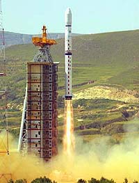
A Changzheng ("Long March") rocket successfully launched China's newest remote sensing satellite last Friday (Sept. 1), Xinhua News Agency announced. A CZ-4B launcher lifted off from the Taiyuan Satellite Launching Center (TSLC) in the northern Shanxi Province at 11:25 a.m. Beijing Time (0325 UTC). Telemetry received at the Xi'an Satellite Control Centre in the central Shaanxi Province indicated that the new remote sensing satellite, Ziyuan-2 (ZY-2, "Ziyuan" means resource), successfully separated from the launcher twelve minutes after launch and reached the planned polar sun-synchronous orbit. This is the third successful flight of CZ-4B, which is an enhanced version of CZ-4A. The mission is the 62nd launch of the CZ series of rockets and the 20th consecutive successful launch. The CZ-4B launcher used in this flight is 45 meters long with a liftoff mass of 250 tonnes. ZY-2 is the second in the series of Ziyuan remote sensing satellites. The first satellite, also called CBERS-1 which was launched last October, was a collaborative project between China and Brazil. The newly launched satellite, however, is not the successor to CBERS-1. The second CBERS satellite is not expected to go into space until the end of next year. ZY-2 will be used primarily in territorial surveying, city planning, crop yield assessment, disaster monitoring, and space science experimentation. Remote sensing experts point out that the successful launch of ZY-2 signifies advancement of Chinese technologies in this field. They also believe that applications of remote sensing satellites will help push the national economy forward. Meanwhile Taiwan has expressed concern with the ZY-2 launch. Taiwanese media reports that their defense department is monitoring the progress of the mission. Taiwan Defense Minister Wu Shih-wen said that since personnel from the China Central Military Committee attended the satellite launch, the Taiwan Defense Department assessed that ZY-2 might also have military application and thus warranted a closer monitoring of the mission. Unnamed Taiwanese intelligence officers were quoted as saying that all previous Chinese remote sensing satellites had image resolution of more than 10 meters, which had little military value. If the image resolution of the ZY-2 imagery is less than 5 meters, the satellite would have military applications in terms of photoreconnaissance. These intelligence officers speculate that ZY-2 employs a digital imaging system instead of using photographic emulsions as in previous remote sensing missions. In these missions reentry capsules returned the exposed films to Earth for processing and analyses. Xinhua News Agency did not disclose details of the ZY-2 payloads and their specifications following the launch. Related Links SpaceDaily Search SpaceDaily Subscribe To SpaceDaily Express  China Plans Colour Capable Remote Sensing Satellite To Study Oceans
Beijing - August 18, 2000 - China plans to launch a satellite to observe ocean colours and survey the great seas, says Xinhua News Agency. According to information in a recently issued report, the State Oceanic Administration is looking into launching the nation's first ocean colour remote sensing satellite next year.
|
| ||||||||||
| The content herein, unless otherwise known to be public domain, are Copyright 1995-2016 - Space Media Network. All websites are published in Australia and are solely subject to Australian law and governed by Fair Use principals for news reporting and research purposes. AFP, UPI and IANS news wire stories are copyright Agence France-Presse, United Press International and Indo-Asia News Service. ESA news reports are copyright European Space Agency. All NASA sourced material is public domain. Additional copyrights may apply in whole or part to other bona fide parties. Advertising does not imply endorsement, agreement or approval of any opinions, statements or information provided by Space Media Network on any Web page published or hosted by Space Media Network. Privacy Statement All images and articles appearing on Space Media Network have been edited or digitally altered in some way. Any requests to remove copyright material will be acted upon in a timely and appropriate manner. Any attempt to extort money from Space Media Network will be ignored and reported to Australian Law Enforcement Agencies as a potential case of financial fraud involving the use of a telephonic carriage device or postal service. |