|
|
| . |  |
. |
|
|
by Staff Writers Berlin, Germany (SPX) Nov 25, 2012
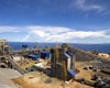
Glasses are rattling on the shelves and the ground is rumbling - since January 2011 the earth under the Santorini volcano has been stirring. Most of the time, it is barely noticeable, but every now and then the inhabitants notice small tremors jolting the volcanic archipelago. Nearly circular, and seemingly carved from stone, the submerged caldera is located in the Aegean Sea. "It was clear to the local people that something was happening with the volcano - but it wasn't until we saw, among other things, the images from the TerraSAR-X radar satellite that we realised that molten rock was pooling beneath the volcano," says British scientist Juliet Biggs from the University of Bristol. Images acquired by the German Aerospace Center's (Deutsches Zentrum fur Luft- und Raumfahrt; DLR) satellite show the entire archipelago not just rising, but also expanding. It has been 3600 years since a powerful explosion formed the large caldera. Since then, a new vent has been gradually forming in the middle of this basin, where today the Kameni islands protrude from the water. The volcano last erupted in 1950 and then fell dormant again, so the scientists from Oxford and Bristol were all the more surprised when the inhabitants started reporting tremors. "Tour guides, who often visit the volcano with tourists on a daily basis, told me there was an increase in the quantity of strong smelling gas being released by the summit," explains PhD student Michelle Parks. "The colour of the sea had changed as well."
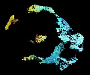
Expanding magma chamber Using GPS receivers, they determined precise locations with millimetric accuracy on a daily basis. The TerraSAR-X radar satellite also observed the archipelago from orbit, at an altitude of 514 kilometres, recording its uplift and expansion from one orbit to the next. The results showed that the Kameni islands had risen eight to 14 centimetres in many places. The breadth of the caldera as a whole has increased by about 14 centimetres since early 2011. In the analysis of the radar data, the red and yellow shading shows the areas where the ground has risen the most. The main island of Thira is unaffected by the deformation, thus appearing blue. "We believe that a magma chamber has formed at a depth of four kilometres," explains Biggs. "From January 2011 to April 2012, this chamber full of molten rock has increased in size by 10 to 20 million cubic metres." This makes it around 8 to 15 times as big as the Olympic stadium in London, the researcher estimates. The volume of molten rock that has accumulated under the volcano in the past year is about the same as the volcano normally accumulates in 10 to 20 years. "However, this does not mean that an eruption is imminent," says Biggs.
Present day situation, seen by radar "Most volcanologists investigate rock from previous eruptions to understand what has happened in the past," says Biggs, who has specialised in analysing radar data to understand the physical processes that change Earth. "It is very exciting to be able to use satellite technology to investigate what is happening today in a volcanic system."
The TerraSAR-X mission The satellite travels around the Earth in a polar orbit and records unique, high-quality X-band radar data about the entire planet using its active antenna. TerraSAR-X works regardless of weather conditions, cloud cover or the absence of daylight and is able to provide radar data with a resolution down to one metre. DLR is responsible for using TerraSAR-X data for scientific purposes. It is also responsible for planning and implementing the mission as well as controlling the satellite. Astrium built the satellite and shares the costs of developing and using it. Infoterra GmbH, a subsidiary company founded specifically for this purpose by Astrium, is responsible for marketing the data commercially.
Related Links DLR Earth Observation News - Suppiliers, Technology and Application
|
|
| The content herein, unless otherwise known to be public domain, are Copyright 1995-2014 - Space Media Network. AFP, UPI and IANS news wire stories are copyright Agence France-Presse, United Press International and Indo-Asia News Service. ESA Portal Reports are copyright European Space Agency. All NASA sourced material is public domain. Additional copyrights may apply in whole or part to other bona fide parties. Advertising does not imply endorsement,agreement or approval of any opinions, statements or information provided by Space Media Network on any Web page published or hosted by Space Media Network. Privacy Statement |
 del.icio.us
 Digg
Digg Reddit
 Google