|
|
| . |  |
. |
|
|
by Staff Writers Washington DC (SPX) May 28, 2014
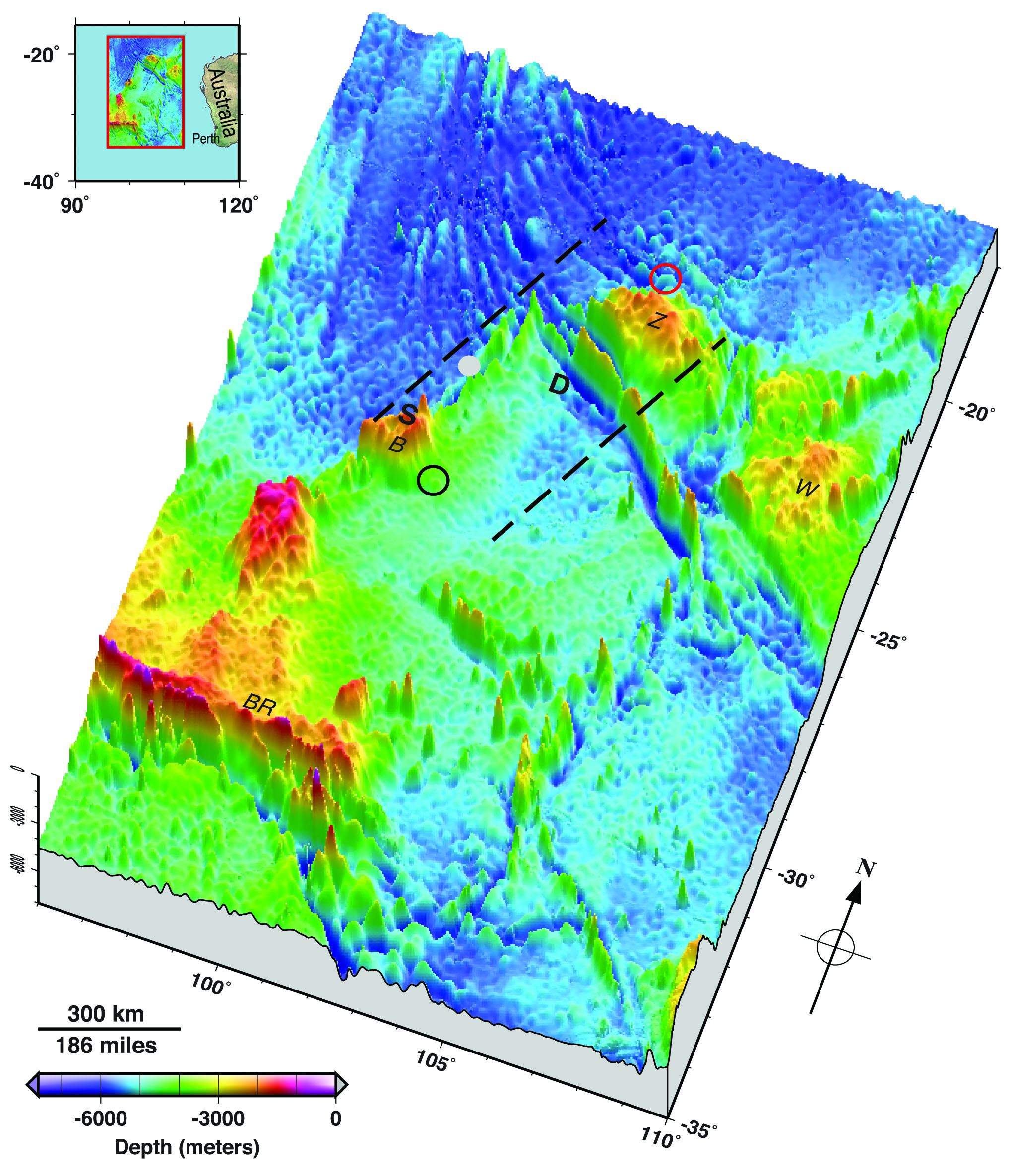
A new illustration of the seafloor, created by two of the world's leading ocean floor mapping experts that details underwater terrain where the missing Malaysia Airlines flight might be located, could shed additional light on what type of underwater vehicles might be used to find the missing airplane and where any debris from the crash might lie. The seafloor topography map illustrates jagged plateaus, ridges and other underwater features of a large area underneath the Indian Ocean where search efforts have focused since contact with Malaysia Airlines flight MH370 was lost on March 8. The image was published in Eos, the weekly newspaper of the Earth and space sciences, published by the American Geophysical Union. The new illustration of a 2,000 kilometer by 1,400 kilometer (1,243 miles by 870 miles) area where the plane might be shows locations on the seafloor corresponding to where acoustic signals from the airplane's black boxes were reportedly detected at the surface by two vessels in the area. It also shows the two plateaus near where these "pings" were heard. It points out the deepest point in the area: 7,883 meters (about five miles) underneath the sea in the Wallaby-Zenith Fracture Zone - about as deep as 20 Empire State buildings stacked top to bottom. Undersea mountains and plateaus rise nearly 5,000 meters (about three miles) above the deep seafloor, according to the map. The illustration, designated as Figure 1 of the Eos article, was created by Walter H.F. Smith and Karen M. Marks, both of the National Oceanic and Atmospheric Administration's Laboratory for Satellite Altimetry in College Park, Maryland, and the former and current chairs, respectively, of the Technical Sub-Committee on Ocean Mapping of the General Bathymetric Chart of the Oceans, or GEBCO. GEBCO is an international organization that aims to provide the most authoritative publicly available maps of the depths and shapes of the terrain underneath the world's oceans. Satellite altimetry has made it possible to depict the topography of vast regions of the seafloor that would otherwise have remained unmapped, Smith said. To illustrate the topography of the search area, Smith and Marks used publicly available data from GEBCO and other bathymetric models and data banks, along with information culled from news reports. Smith said the terrain and depths shown in the map could help searchers choose the appropriate underwater robotic vehicles they might use to look for the missing plane. Knowing the roughness and shape of the ocean floor could also help inform models predicting where floating debris from the airplane might turn up. Smith cautions that the new illustration is not a roadmap to find the missing airplane. Nor does the map define the official search area for the aircraft, he added. "It is not 'x marks the spot'," Smith said of their map. "We are painting with a very, very broad brush." Search efforts for the missing airplane have focused on an area of the southern Indian Ocean west of Australia where officials suspect that the plane crashed after it veered off course. After an initial air and underwater search failed to find any trace of the airplane, authorities announced this month that they will expand the search area and also map the seabed in the area. Smith pointed out that the search for the missing plane is made more difficult because so little is understood about the seafloor in this part of the Indian Ocean. In the southeast Indian Ocean, only 5 percent of the ocean bottom has been measured by ships with echo soundings. Knowledge of the rest of the area comes from satellite altimetry, which provides relatively low-resolution mapping compared to ship-borne methods. "It is a very complex part of the world that is very poorly known," Smith said. A lack of good data about Earth's seafloors not only hinders search efforts, it also makes it harder for scientists to accurately model the world's environment and climate, Smith noted. Today, our knowledge of our planet's undersea topography is "vastly poorer than our knowledge of the topographies of Earth's Moon, Mars and Venus," Smith and Marks write in Eos. This is because these other planetary bodies have no oceans, making their surfaces relatively easy to sense from space. Smith said he hoped that "the data collected during the search for MH370 will be contributed to public data banks and will be a start of greater efforts to map Earth's ocean floor."
Related Links AGU Aerospace News at SpaceMart.com
|
|
| The content herein, unless otherwise known to be public domain, are Copyright 1995-2014 - Space Media Network. All websites are published in Australia and are solely subject to Australian law and governed by Fair Use principals for news reporting and research purposes. AFP, UPI and IANS news wire stories are copyright Agence France-Presse, United Press International and Indo-Asia News Service. ESA news reports are copyright European Space Agency. All NASA sourced material is public domain. Additional copyrights may apply in whole or part to other bona fide parties. Advertising does not imply endorsement, agreement or approval of any opinions, statements or information provided by Space Media Network on any Web page published or hosted by Space Media Network. Privacy Statement All images and articles appearing on Space Media Network have been edited or digitally altered in some way. Any requests to remove copyright material will be acted upon in a timely and appropriate manner. Any attempt to extort money from Space Media Network will be ignored and reported to Australian Law Enforcement Agencies as a potential case of financial fraud involving the use of a telephonic carriage device or postal service. |

 del.icio.us
 Digg
Digg Reddit
 Google