| . |  |
. |
Stanford - Dec 09, 2003 To some, the $100 million, five-year effort to sprinkle seismic sensors in Alaska and throughout the western United States is known as the Plate Boundary Observatory (PBO). But to geophysicist Paul Segall it is something more. "This kind of thing happens once in a career," says Segall, a professor of geophysics at Stanford University who chairs the PBO advisory board that determined just how this sprinkling should occur. PBO is part of the $219 million EarthScope project to understand no less than the structure and evolution of the entire North American continent. The National Science Foundation (NSF), which is funding the project, notes that EarthScope was launched exactly 200 years after the Lewis and Clark Expedition. "This time, however, instead of toting sextants and compasses to map the surface, scientists will bring seismometers, state-of-the art drilling equipment, satellites and Global Positioning System (GPS) receivers to map Earth's interior," according to the NSF website.
Plate boundary This boundary will be the focus of PBO. "It is where the action is," Segall said. The grinding action generates subtle deformation across the continent. Eventually, hundreds of sensors will be in place to measure this deformation and help geologists understand the shifting strains in the ground. But first, Segall and his colleagues need to answer some questions, including two that will be discussed at the American Geophysical Union (AGU) conference in San Francisco on Dec. 10. Setting up sensors, reading results Lest they be accused of not being creative, consider how geologists usually decide where to place expensive equipment such as GPS receivers. "Typically it is by gut feel," Segall said. In a project compared to Lewis and Clark's Corps of Discovery, gut feel just won't do. So Segall, along with University of Oregon geologist David Schmidt and Stanford graduate student Jessica Murray, built mathematical models to figure out exactly how these sensors should be arrayed across the landscape. It's a good thing they did. Their models suggested several changes in how to configure the network, particularly in the seismically active Pacific Northwest. Segall compared the work to optimize the sensor network to the work of astronomers to design telescopes. Stargazers pick one type of instrument to look at objects nearby in the solar system and another type to peer into deep space, he said. Similarly, the sensors might be set up differently depending on the specific seismic effects, depths and time scales his colleagues are interested in. According to Segall, the models that Schmidt will present at the AGU conference will make it easier for competing research interests to compromise. Another fundamental issue facing researchers is how to interpret the data returned by the sensors - an analog to the age-old problem in science of distinguishing signal from noise. Devices called strainmeters that measure deformation deep in the Earth are planned to be used in the project. But the devices are very sensitive. It is difficult to determine if the data represent widespread aftereffects of a volcanic eruption or a small, insignificant crack appearing in the rock near the device itself, Segall explained: "They feel everything." At the AGU conference, Segall will talk about the challenges of understanding the data returned by these devices. Given that PBO sensors are scheduled to be installed early next year, there is an urgency behind this math-heavy topic. "There are only a few dozen strainmeters around the world today, but we are set to install around 200 of them," he noted.
From sextants to seismometers And he won't be the only one participating in this once-in-a-career event. According to NSF, all EarthScope data will be made available in close to real time on the web for the benefit of academics and amateurs alike.
Well-water studies Segall used a unique combination of new and old technology. Color-coded satellite images revealed changes in the crust after the quake, while galoshes-clad researchers on the ground took measurements from wells that dot the Icelandic landscape. He found a clear correlation between the two sets of data. In effect, the shifting water levels revealed the shifting stresses in the Earth's crust following the quakes. Peter Gilles, geologist at the University of California-Los Angeles and NASA's Jet Propulsion Laboratory, said the results might have a practical use. "One of the main concerns after a major earthquake is the possible triggering of other earthquakes on nearby faults," Gilles said. "Understanding how the stress is modified on adjacent faults has direct implications on risk assessment after an event." Segall's Icelandic results are described in the July 10 issue of the journal Nature. Geoff Koch is a Stanford University graduate student in journalism. Related Links Earth Scope SpaceDaily Search SpaceDaily Subscribe To SpaceDaily Express 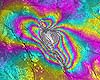 Houston - Dec 08, 2003
Seismologists have long known that the buildup of forces along fault zones cause the physical properties of rock and sediments to change deep inside the Earth, at the level where earthquakes occur. Based upon new findings, researchers believe they may be able to design active seismic monitoring systems that continually monitor these subtle changes, looking for telltale signs of an impending earthquake.
|
| ||||||||||
| The content herein, unless otherwise known to be public domain, are Copyright 1995-2016 - Space Media Network. All websites are published in Australia and are solely subject to Australian law and governed by Fair Use principals for news reporting and research purposes. AFP, UPI and IANS news wire stories are copyright Agence France-Presse, United Press International and Indo-Asia News Service. ESA news reports are copyright European Space Agency. All NASA sourced material is public domain. Additional copyrights may apply in whole or part to other bona fide parties. Advertising does not imply endorsement, agreement or approval of any opinions, statements or information provided by Space Media Network on any Web page published or hosted by Space Media Network. Privacy Statement All images and articles appearing on Space Media Network have been edited or digitally altered in some way. Any requests to remove copyright material will be acted upon in a timely and appropriate manner. Any attempt to extort money from Space Media Network will be ignored and reported to Australian Law Enforcement Agencies as a potential case of financial fraud involving the use of a telephonic carriage device or postal service. |
