| . |  |
. |
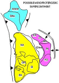
In 1912, German meteorologist Alfred Wegener proposed a theory that first angered and then intrigued scientists and others ever since. Continents shifted around at far slower than a snail's pace throughout Earth's history like pieces of a puzzle, drifting together and pulling apart to form oceans, he said. Part of the eventual fascination with his idea came from globe-gazers' observation that continents such as Africa and South America look like they could fit together snugly. Following up on Wegener and others' work, a University of North Carolina at Chapel Hill geologist believes he has discovered a new, long-vanished supercontinent. That early amalgamation of most of the world's continents in one vast land area later split up several times, reformed and divided again to begin shaping Earth's current continents. The primeval supercontinent, which Professor John J.W. Rogers named Columbia, existed more than 1.5 billion years ago and is older than any of several giant landmasses previously proposed. "I named the supercontinent Columbia because some of the best evidence for its existence is in the Columbia River region of western North America," Rogers said. "Starting at about 1.8 billion years ago, all of the continents existing at that time began to collide into a single land area." Rogers describes his ideas in a scientific paper with fellow geologist Dr. M. Santosh of Kochi University in Japan published in the current issue of the Gondwana Research, a quarterly journal devoted to studies of Earth's early land masses. The east coast of India became attached to western North America, with southern Australia against western Canada, he said. Most of present South America rotated so that the western edge of Brazil lined up with eastern North America, forming a continental margin that extended into the southern edge of Scandinavia. "This formed an area that stretched about 8,000 miles from southern South America to northern Canada and was about 3,000 miles across at its widest part," Rogers said. Columbia began to break up about 1.5 billion years ago, and its fragments moved around the Earth independently for several hundred million years, he said. About a billion years ago, the fragments came together again to form a new supercontinent, called Rodinia. Rodinia lasted until about 700 million years ago before it too broke into several fragments. These chunks moved independently until 250 million years ago, when the supercontinent Pangea formed, Rogers said. Pangea then began to break up almost immediately to form the world's present continents. "This sequence of formation and dispersal of supercontinents is clearly caused by movements deep within the Earth in a layer scientists call the mantle," he said. "The exact mechanism is still being worked out, and hopefully the discovery of Columbia will contribute to understanding it." Magnetic and geologic evidence for supercontinents becomes less certain and more controversial as the age of the supercontinent increases, Rogers said. For that reason, the shape of Columbia and even its existence is less certain than that of Rodinia. Originally trained as petrologist and geochemist, the UNC scientist came up with his ideas while traveling in the Orkney Islands off Scotland's north coast. He based them on data he collected in India, East Africa and Saudi Arabia as U.S. leader of a joint Indian and U.S. cooperative study of the Precambrian evolution of southern India and on data published by other scientists. Geologists date ancient rocks by measuring radioactive decay of uranium and lead isotopes. Comparisons of such information and rock types around the world reveal what regions used to be connected.
Geologists Locate Boundary Between African Plates The northern boundary between the west African (Nubian) plate and the east African (Somalian) plate has long been identified as the East African Rift Valley. From the time plate tectonics was proposed in the mid-1960s, geologists have speculated about whether, and in what direction, the boundary continues from the south end of the rift valley, beyond which seismic and volcanic activity disappear. Rice geologists Richard G. Gordon and James Lemaux II, along with geologist Jean-Yves Royer of the Institut Universitaire Europ�en de la Mer (France), report their findings in the April issue of the journal Geology. Comparing records of magnetic variations in the seafloor of the southern Indian Ocean, they located the intersection of the Nubian, Somalian and Antarctic plates within a 100-kilometer-wide region known as the Andrew Bain Fracture Zone Complex. The submarine complex, located south of Africa, is more than 1,000 miles long and, at its southern end, intersects the northern boundary of the Antarctic plate. "This boundary has been elusive because there is very slow movement between the Somalian and Nubian plates," said Gordon, the W.M. Keck Professor of Geophysics. "Both plates are moving away from Antarctica, but the Somalian plate is moving slightly slower, so the relative movement between the African plates is only about two millimeters per year." Gordon, Royer and Lemaux, now with BP Exploration (Alaska) Inc., determined movement rates for the African plates by studying the magnetic profile of the seafloor on both sides of the slowly slipping fault zone. New seafloor is continuously created as the African plates pull away from Antarctica. Because the Earth's magnetic field changes polarity about every 500,000 years, the seafloor appears as a series of bands, each with reverse polarity from the next. Like rings of a tree, these bands can be used to date the creation of seafloor, and they can be matched up from opposite sides of the fault zone to gauge how far plates have moved relative to one another. The Rice researchers compared the magnetic signature of a single band in 237 locations � six times as many as in prior studies of the region � to determine the relative movement of the plates and to pinpoint the location of the boundary zone between the two African plates. The research, funded by the National Science Foundation and the French National Scientific Research Center, allows geologists to better understand the relationship between the African plates, including the tectonic processes that created the East African Rift. The findings should also allow geologists to improve software models that predict the tectonic motion, giving a clearer picture of what's likely to happen not only in the rift valley, but also in other areas such as the Himalayas and Tibetan Plateau, where the Indian and Eurasian plates collide. Related Links University of North Carolina at Chapel Hill Rice University SpaceDaily Search SpaceDaily Subscribe To SpaceDaily Express  Boulder - Jan 25, 2002
The subject of mantle plumes -- bodies of hot buoyant material that rise through Earth's mantle -- has become increasingly popular as scientists explore new links between mantle plumes and other Earth processes.
|
| ||||||||||
| The content herein, unless otherwise known to be public domain, are Copyright 1995-2016 - Space Media Network. All websites are published in Australia and are solely subject to Australian law and governed by Fair Use principals for news reporting and research purposes. AFP, UPI and IANS news wire stories are copyright Agence France-Presse, United Press International and Indo-Asia News Service. ESA news reports are copyright European Space Agency. All NASA sourced material is public domain. Additional copyrights may apply in whole or part to other bona fide parties. Advertising does not imply endorsement, agreement or approval of any opinions, statements or information provided by Space Media Network on any Web page published or hosted by Space Media Network. Privacy Statement All images and articles appearing on Space Media Network have been edited or digitally altered in some way. Any requests to remove copyright material will be acted upon in a timely and appropriate manner. Any attempt to extort money from Space Media Network will be ignored and reported to Australian Law Enforcement Agencies as a potential case of financial fraud involving the use of a telephonic carriage device or postal service. |