| . |  |
. |
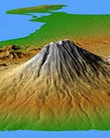
Marco Polo. Alexander the Great. They were some of history's most prolific explorers, each trekking across sweeping stretches of Europe and Asia in their lifetimes. But these greats of world history have nothing on you, thanks to a new topographic data set from NASA and the National Geospatial-Intelligence Agency. You now can explore the vast reaches of most of Europe, Asia and numerous islands in the Indian and Pacific Oceans, from the comfort of home, without breaking a sweat. Gathered in just 10 days by NASA's Shuttle Radar Topography Mission in February 2000, the new digital elevation data set showcases some of Earth's most diverse, mysterious and extreme topography. Much of it previously had been very poorly mapped due to persistent cloud cover or inaccessible terrain. The new data being released comprise about 40 percent of the entire mission data set. "People around the world will benefit from the release of the mission's Europe and Asia topographic data sets because they greatly extend our knowledge of this immense region that also is home to most of Earth's citizens," said Dr. John LaBrecque, manager, Solid Earth and Natural Hazards Program, NASA Headquarters, Washington. "The shape of Earth's surface affects nearly every natural process and human endeavor. Precise, uniform 3-D elevation data are needed for a wide range of applications from studying earthquakes, volcanism, floods and other natural hazards, to planning development, managing precious water resources, and insuring the safety of aircraft navigation." "Releasing the Eurasia SRTM data provides geospatial data users with a remarkably consistent Earth-elevation surface," said National Geospatial-Intelligence Agency Technical Executive Roberta Lenczowski. "This enhances our global knowledge, provides a baseline for any future comparisons, and delivers accuracy and integrity unparalleled in any other global-elevation model of the Earth. "This The mission's data represents 40 percent of the data collected during the mission, which covered roughly 80 percent of the landmass of the Earth. The cooperative effort between NASA and the National Geospatial-Intelligence Agency, fusing science objectives with national security requirements, benefits all." The area covered in the current data release stretches eastward from the British Isles and the Iberian Peninsula in the west, across the Alps and Carpathian Mountains, as well as the Northern European Plain, to the Ural and Caucasus Mountains bordering Asia. The Asian coverage includes a great variety of landforms, including the Tibetan Plateau, Tarin Basin, Mongolian Plateau and the mountains surrounding Lake Baikal, the world's deepest lake. Mt. Everest in the Himalayas, at 8,848 meters (29,029 feet) is the world's highest mountain. From India's Deccan Plateau, to Southeast Asia, coastal China, and Korea, various landforms place constraints on land-use planning during periods of population growth. Volcanoes in the East Indies, the Philippines, Japan and the Kamchatka Peninsula form the western part of the "Ring of Fire" around the Pacific Ocean. Previous releases from the mission covered North and South America. Forthcoming releases in 2004 will include Africa-Arabia and Australia, as well as an "islands" release for those islands not included in the continental data releases. Together, these data releases constitute the world's first high-resolution, near-global elevation model. The resolution of these data for Europe and Asia is three arc seconds (1/1,200th of a degree of latitude and longitude), which is about 90 meters (295 feet). The mission is a cooperative project of NASA, the National Geospatial- Intelligence Agency and the German and Italian space agencies. NASA's Jet Propulsion Laboratory, Pasadena, Calif., processed the data into research-quality digital elevation data. The National Geospatial-Intelligence Agency is providing additional processing to develop mapping products. The U.S. Geological Survey Earth Resources Observation Systems Data Center in Sioux Falls, S.D., provides final archiving and distribution of the Shuttle Radar Topography Mission data products.
The new images are available on the JPL Planetary Photojournal as:
Related Links
Shuttle Radar Topography Mission National Geospatial-Intelligence Agency SpaceDaily Search SpaceDaily Subscribe To SpaceDaily Express  El Segundo - Dec 18, 2003
Northrop Grumman Corporation and the U.S. Air Force have received authorization from the Department of Defense to develop and produce hardware for an airborne radar system that will dramatically increase the service's ability to detect, track and identify both stationary and moving ground vehicles, and low-flying cruise missiles.
|
| ||||||||||
| The content herein, unless otherwise known to be public domain, are Copyright 1995-2016 - Space Media Network. All websites are published in Australia and are solely subject to Australian law and governed by Fair Use principals for news reporting and research purposes. AFP, UPI and IANS news wire stories are copyright Agence France-Presse, United Press International and Indo-Asia News Service. ESA news reports are copyright European Space Agency. All NASA sourced material is public domain. Additional copyrights may apply in whole or part to other bona fide parties. Advertising does not imply endorsement, agreement or approval of any opinions, statements or information provided by Space Media Network on any Web page published or hosted by Space Media Network. Privacy Statement All images and articles appearing on Space Media Network have been edited or digitally altered in some way. Any requests to remove copyright material will be acted upon in a timely and appropriate manner. Any attempt to extort money from Space Media Network will be ignored and reported to Australian Law Enforcement Agencies as a potential case of financial fraud involving the use of a telephonic carriage device or postal service. |