| . |  |
. |
The overall operational performance of all spacecraft subsystems is good. Following difficulties encountered with the Solid State Mass Memory (SSMM) in the March-April timeframe, the upload of a new Solid State Mass Memory software version took place successfully in mid-April. No science operations were possible during the few days dedicated to this operation. With eclipse durations lasting less than 40 minutes per orbit, spacecraft power resources are less constrained. As a result, an intensified science operations programme has been possible with longer observations and up to two science pointings per orbit. The deployment of the MARSIS radar booms was originally planned for the period from the second half of April to the beginning of May. This operational activity had to be postponed on request of the MARSIS team due to new antenna deployment simulation results. The G3u to G3b orbit change manoeuvre, performed in order to maintain the planned latitudinal and seasonal coverage, was executed, as planned, on 6 May. Remaining payload-commissioning activities are being performed until June 2004. The MARSIS radar will be deployed as soon as possible and subsequently fully commissioned.
Summary of Scientific Results Following the Mars Express spacecraft commissioning in January 2004, most experiments have begun their own calibration and testing phase and are already acquiring scientific data. This phase will last until June when all the instruments will start their routine science operations. The MARSIS radar antennas, however, will only be deployed in early May in order to maximise daylight operations of the other instruments before the pericentre natural drift to the Southern latitudes, which coincides with night time conditions required for subsurface sounding. High-Resolution Stereo Colour Imager (HRSC) Continues to acquire breathtaking views of the planet, in particular of karstic regions near the Valles Marineris canyon (pointing to liquid water as the erosional agent responsible for modifying tectonic and impact features in the area) and of several large volcanoes (Olympus Mons caldera and glaciation features surrounding Hecates Tholus). OMEGA Providing unprecedented maps of water ice and CO2 ice occurrence at the south pole, showing where the two ices mix and where they do not. Planetary Fourier Spectrometer (PFS) Measuring atmospheric CO variations in each hemisphere and confirming the presence of methane for the first time, which would indicate current volcanic activity and/or biological processes. UV and IR Atmospheric Spectrometer (SPICAM) Providing the first complete vertical profile of CO2 density and temperature, and has simultaneously measured the distribution of water vapour and ozone. Energetic Neutral Atoms Analyser (ASPERA) Identifying the solar wind interaction with the upper atmosphere and measuring the properties of the planetary wind in the Mars tail. Radio Science Experiment (MaRS) Studying, for the first time, the surface roughness by pointing the spacecraft high-gain antenna to the Martian surface, which reflects the signal before sending it to Earth. Also, the martian interior has been probed by studying the gravity anomalies affecting the orbit due to mass variations of the crust.
Discussion on Scientific Results The unifying theme of the mission is the study and search for water by all instruments using different techniques. Geological evidence, such as dry riverbeds, sediments and eroded features, indicates that water has played a major role in the early history of the planet. It is assumed that liquid, probably water, was present on the surface of Mars up to about 3.8 billion years ago (from crater counting relative ages), when the planet had a thicker atmosphere and a warmer climate. Afterwards, the atmosphere became much thinner and the climate much colder, the planet loosing much of its water in the process as liquid water cannot be sustained on the surface under present conditions. Mars Express aims to investigate why this drastic change occurred and where the water went. A precise inventory of existing water on the planet (in ice or liquid form mostly below ground) is important given its implications on the potential evolution of life on Mars, as 3.8 billion years ago is roughly the time when life appeared on our own planet. Thus, it is not unreasonable to imagine that life may also have emerged on Mars and possibly survive the intense UV solar radiation by remaining underground. The discovery of methane in the atmosphere could indicate just that or the presence of active volcanism. From previous orbital imagery, volcanoes on Mars were thought to have been dormant for hundreds of millions of years. This idea needs looking at again as the implications of currently active volcanism are profound in terms of thermal vents providing niches for potential ecosystems, as well as for the thermal history of the planet with the largest volcanoes in the Solar System. Mars Express is already hinting at a quantum leap in our understanding of the planet?s geological evolution.
Upcoming Activities Imaging instruments and spectrometers (for example HRSC, OMEGA, PFS) are continuing global coverage science data acquisition for the purpose of mosaic and map construction. While not yet in the routine science phase, the Mars Express mission has so far been delivering numerous, important measurements of the Martian surface, atmosphere and environment, leading to significant high-quality scientific results which are in the process of being published. Related Links SpaceDaily Search SpaceDaily Subscribe To SpaceDaily Express 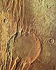 Paris (ESA) May 11, 2004
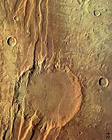
These images were taken by the High Resolution Stereo Camera (HRSC) on board ESA's Mars Express of the Acheron Fossae region, an area of intensive tectonic (continental 'plate') activity in the past.
|
| ||||||||||
| The content herein, unless otherwise known to be public domain, are Copyright 1995-2016 - Space Media Network. All websites are published in Australia and are solely subject to Australian law and governed by Fair Use principals for news reporting and research purposes. AFP, UPI and IANS news wire stories are copyright Agence France-Presse, United Press International and Indo-Asia News Service. ESA news reports are copyright European Space Agency. All NASA sourced material is public domain. Additional copyrights may apply in whole or part to other bona fide parties. Advertising does not imply endorsement, agreement or approval of any opinions, statements or information provided by Space Media Network on any Web page published or hosted by Space Media Network. Privacy Statement All images and articles appearing on Space Media Network have been edited or digitally altered in some way. Any requests to remove copyright material will be acted upon in a timely and appropriate manner. Any attempt to extort money from Space Media Network will be ignored and reported to Australian Law Enforcement Agencies as a potential case of financial fraud involving the use of a telephonic carriage device or postal service. |