| . |  |
. |
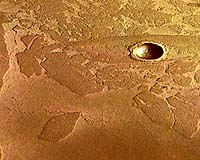
for Astrobiology Magazine Moffett Field CA (SPX) Sep 19, 2005 I want to review some of the highlights that have come from recent missions, starting with the Mars Global Surveyor mission. I'm going to focus on three instruments: the Mars Orbiter Camera (MOC), which is a high-resolution camera that maps at about 2 meters a pixel; the Mars Orbiter Laser Altimeter (MOLA), which has been capable of mapping the surface at a couple of meters' resolution; and the Thermal Emission Spectrometer (TES), which is a mid-infrared instrument, looking at the mineralogy of the surface. And those instruments have really contributed a lot to advancing our understanding of Mars and have affected a lot the way we're approaching subsequent missions. Images taken by the Mariner and Viking orbiters in the 1970s revealed extensive small-valley networks in the southern highlands of Mars, which we've pointed to for a long time now as potential evidence of water on the surface. With the higher-resolution Mars Global Surveyor Mars Orbital Camera, we've been able to see much more detail, including features that look a lot like the canyon lands of northern Arizona. With the Mars Orbiter Camera we're also seeing layered rocks which could be sedimentary, or volcanic. We don't know for sure whether we're looking at original volcanic ash beds, lava flows, or recycled sedimentary materials. But there's layering all over Mars, layered sequences everywhere, which bodes well for anybody who's interested in looking for a sedimentary record, because hiding in there, there probably are sedimentary rocks. The Mars Orbiter Laser Altimeter, which mapped the topography of Mars, has revolutionized our understanding of the geomorphology of the surface of Mars. For example, it revealed that the northern plains of Mars is probably the flattest surface in the solar system. The only thing comparable would be the abyssal plains of our ocean floors. Along with that has come the recognition of at least one continuous terrace, a bench that basically encircles the northern plains, which could be an ancient shoreline. This has added fuel to the claim that maybe Mars once had oceans. And this has helped us follow the water in a different way that wasn't expected early on. TES has been mapping the surface in the mid-IR, looking for compositional variations. One of the important discoveries was of coarse-grained hematite at a place called Meridiani Planum. That was a compelling enough finding to convince the community to want to go there with the Mars Exploration Rover mission, and Opportunity rover has been exploring that site for over a year and a half now. With regard to the question of subsurface water we have reasonable evidence that, early on in the history of Mars, water was abundant at the surface, carving channels, accumulating in basins and forming lakes and maybe even oceans. But over time, perhaps as early as 3.8 billion years ago, Mars began to lose its atmosphere. And with that, it lost the capability to sustain liquid water at its surface. If liquid water's around today, it may exist several kilometers below the surface as a global groundwater system. The question is, How can we begin to address the idea of a subsurface hydrosphere on Mars? Well, the Mars Global Surveyor, in particular the Mars Orbital Camera, has provided some compelling evidence: images of fluid seeps on the polar-facing slopes at high latitudes. Several years ago, Mike Malin and Ken Edgett first published data on about 140 such sites. There are even more now, and it turns out that the latitudinal distribution has expanded as well. One suggestion was that these seeps could have been sites for the escape of hydrothermal brines, or brines that were really saline and were able to maintain their fluidity, even at low temperatures. Recently, Phil Christensen, of Arizona State University, put on the table the idea that during low-obliquity periods a lot of ice and snow moved to these latitudes, that at the base of those snow accumulations there was the potential for basal melting and that the flow of water beneath the ice packs carved these features. Both hypotheses are still on the table right now, probably along with a few others. We don't know for sure what this is telling us, but one thing it does tell us is that probably there has been liquid water at the surface of Mars very recently in martian history. And where you've got water, you've got the potential for habitability. With the Odyssey mission, we've had another insight, which has come from the Gamma Ray Spectrometer. We've learned that large areas, across broad range of latitudes, show evidence for very high hydrogen concentrations in the upper 35 to 50 centimeters of regolith, implying the presence of either water or hydrated minerals. Probably most of this is ground ice. This is a really exciting find, because during obliquity changes that we know have occurred during martian history, these become potential environments for the melting of surface water, for the formation of habitable zones just beneath the surface. With the European Space Agency's Mars Express, we have the opportunity to advance the geomorphological views of Mars, through the High Resolution Stereo Camera (HRSC). The HRSC is mapping the whole surface at 15 to 18 meters per pixel, but nested within that it can get resolution as good as 6 to 8 meters per pixel. It also has the OMEGA instrument, a near-IR spectrometer that is now mapping at 100 meters per pixel, and picking up interesting differences in surface composition. One finding was that there seems to be a lot of sulfate distributed around the planet. Mars Express has also detected methane in the martian atmosphere. That has gotten everyone talking about the possibility of organisms in the subsurface. Finally, there is MARSIS, a radar mapping instrument that can penetrate 3 to 5 kilometers below the surface and potentially detect cryosphere-hydrosphere interfaces. The recently launched Mars Reconnaissance Orbiter is a really exciting mission for us as well, because we're going to get another high-resolution camera, the HiRISE (High Resolution Imaging Science Experiment), which will be mapping at a meter per pixel, and the CRISM (Compact Reconnaissance Imaging Spectrometer for Mars) instrument, which is a near-IR instrument, mapping at 18 meters per pixel. So you can see the potential here for getting not only a lot of astounding geomorphological evidence at high resolution, but also compositional information to lay over that. MRO also is carrying a radar instrument, SHARAD (Shallow Radar), which is going to fill the gap up to shallower depths of 10s of meters down to a kilometer, again looking for these interfaces between the cryosphere and the hydrosphere. We also have landed missions, the Mars Exploration Rovers, Spirit and Opportunity, which are asking more specific questions. Because we're on the surface we can better resolve surface composition. We can get much more detailed in our understanding of mineralogy, the potential for organic chemistry, and really begin to pin down past or present environments and their potential for supporting life from the standpoints of water, nutrients and energy. This basic rationale for undertaking surface missions to carry out this kind of definitive mineralogy and geochemistry (including isotopic chemistry and organic surveys), is to create a needed synergy between the orbital data that we've been getting and the ground truth. One bit of synergy that we've been able to achieve is particularly important: Remember the hematite signatures that the TES instrument spotted from orbit in Meridiani Planum, which was a compelling reason to go there in the first place? We've now been able to connect that to surface materials, the hematite blueberries that cover large areas of the plains of Meridiani. There's a whole story with water there, quite complex. We all had hypotheses about what the hematite signature meant initially. None of us got it right. Once we got onto the surface, we really started to get down to the nitty-gritty of what that signature meant. It still means water, but a much more complicated kind of aqueous history than we had expected. The Phoenix mission, which will launch in 2007, is a Scout mission. These are missions that NASA put into the program, cost-capped at about $350 million, that are designed to answer very focused questions, much more focused than the broader programmatic missions. In 2007, we'll launch Phoenix, which is going to include an in-situ volatile- and organic-chemistry lab that's going to analyze frozen soils and ices at a polar landing site. It will be our first attempt since Viking to look at organic chemistry on the surface of Mars. Finally, there's the Mars Science Laboratory, which will launch in 2009. This is going to be the next set of wheels on Mars (Phoenix will be a fixed lander). It's going to carry a diverse payload that will enable definitive chemistry. It will be able to do integrated mineralogy and geochemistry of martian surface materials, and will have advanced capabilities for the analysis of organic matter in rocks, soils and ices. Related Links SpaceDaily Search SpaceDaily Subscribe To SpaceDaily Express  Cambridge, England (UPI) Sep 13, 2005
NASA's Mars Express space probe that entered orbit at the end of 2003 may have found evidence of a band of ice that once spanned the Martian equator.
|
| ||||||||||
| The content herein, unless otherwise known to be public domain, are Copyright 1995-2016 - Space Media Network. All websites are published in Australia and are solely subject to Australian law and governed by Fair Use principals for news reporting and research purposes. AFP, UPI and IANS news wire stories are copyright Agence France-Presse, United Press International and Indo-Asia News Service. ESA news reports are copyright European Space Agency. All NASA sourced material is public domain. Additional copyrights may apply in whole or part to other bona fide parties. Advertising does not imply endorsement, agreement or approval of any opinions, statements or information provided by Space Media Network on any Web page published or hosted by Space Media Network. Privacy Statement All images and articles appearing on Space Media Network have been edited or digitally altered in some way. Any requests to remove copyright material will be acted upon in a timely and appropriate manner. Any attempt to extort money from Space Media Network will be ignored and reported to Australian Law Enforcement Agencies as a potential case of financial fraud involving the use of a telephonic carriage device or postal service. |