| . |  |
. |
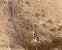
Sacramento (SPX) Jun 08, 2004 But while the ability of Spirit to locate water-deposited and -modified material on Mars' surface is still in doubt, its twin Opportunity has rather stolen its thunder by finding solid proof of such material almost as soon as it landed on the strange, flat, hematite-covered Meridiani Plain. And it too is likely to begin a vital new phase of its exploration next week; its operators have decided that they will probably run the risk of having it descend the upper five to seven meters of the rather steep slope of "Endurance", the 130-meter wide crater along whose rim it has been wandering since its arrival there on May 4. While Endurance is only modestly bigger than Bonneville Crater on the Gusev plain, it has most definitely NOT been a scientific red herring. Opportunity spent its first two months happily poking around "Eagle" - the little 22-meter wide depression into which the lander originally bounced and rolled, and whose walls contained an outcrop of finely layered light-colored rock only 40 cm thick which provided quick and dramatic proof that the Meridiani plain was exposed to substantial amounts of surface or near-surface groundwater during the Noachian Era. This alone would have been sufficient to make the mission a success; but Opportunity then climbed out of the crater and raced about 800 meters in one month across the remarkably flat, virtually rock-free main Meridiani plain to the edge of Endurance crater. The hematite-rich part of Meridiani Plain - the size of Oklahoma - looked from the start very peculiar from orbit. It consisted of a sea of dark material, rich in both regular volcanic basalt and gray hematite (made of much coarser crystals than the extremely fine-grained "nanophase" red hematite, formed by atmospheric processes, that colors all of Mars' fine dust), which seemed to be overlaid on top of a layer of much lighter-colored rock that appeared to be formed as layers. This light-colored rock is referred to as the "Etched" layer, although it should in no way be confused with the different-composition "Etched" hillocks on the floor of Gusev crater. Individual large patches and islands of this light-colored rock still stick up above the dark hematite-rich layer all over the region, but the latter appears to be encroaching on them. Such gray hematite - usually formed by aqueous processes - has been found from orbit so far in only two other, much smaller places on Mars' current surface. After Opportunity landed, the reason for this peculiar setup quickly became apparent. The gray hematite is in the form of trillions of tiny round pellets. They've been nicknamed "Blueberries" because of their relatively bluish appearance in the multi spectra false-color photos the rover has taken to identify different mineral types. In reality, though, they're not only gray to the human eye, but only one to two millimeters across, more like birdseed than blueberries. They initially formed embedded within the light-colored rock - which turns out to consist mostly of a soft matrix made up of similarly fine layers only a few mm thick, rather like baklava. This deposit was apparently covered with other kinds of soil by various Martian surface processes fairly soon after the period, 3.5 to 4 billion years ago, in which it formed. But in just the past few tens of millions of years, the slowly changing atmospheric erosion patterns of Mars have finally uncovered it again. And now the wind is causing dry, olivine-rich ordinary basalt sand to sift into this area from the surrounding parts of Mars, and those sand grains are gradually powderizing the soft light-colored matrix rock from the top down, leaving behind an upper layer of relatively hard hematite Blueberries mixed with the encroaching basalt sand on top of the remaining layers of light-colored Etched rock. The patches of Etched rock still visible from orbit have just been a bit slower to erode, and so are now hummocks a little higher - maybe less than a meter - above the encroaching shallow sea of dark basalt sand and gray detached Blueberries surrounding them and slowly eating into them from the sides. Opportunity's compositional instruments quickly established that the light-colored matrix rock in the Etched layer is a mixture of soft silica minerals (either amorphous or formed into fine flaky layers) mixed with large amounts of the hydrated iron sulfate "jarosite", and even larger amounts of magnesium and calcium sulfates. That calcium sulfate is an especially soft mineral - called "anhydrite" when it's completely dry, and "gypsum" when it's chemically hydrated by contact with water. It seems to have formed largely as small tablet-shaped crystals that have eroded even more quickly out of the exposed outer surfaces of Etched rock, leaving behind "vugs" - small hollow slots speckling the surface of the Etched rock almost as densely as the Blueberries do. Since calcium sulfate also dissolves extremely easily on contact with water, it's possible that its crystals have been cleaned out of the vugs not only by erosion from windblown basalt sand, but by repeated exposures to tiny traces of liquid water produced from the thawing of thin snow or frost layers on this part of Mars' surface during the planet's perpetually repeated hundred-thousand-year climate cycles as its degree of axial tilt repeatedly rocks up and down. Such repeated water traces may also have helped Mars' winds in cleaning away the rest of the fine dust made out of the powderized etched rock ground up by the sand's erosion. Now, what could have made this stuff? The MER science team is still not certain. But Nicholas Tosca of the State University of New York had run an extremely suggestive lab experiment just a few months earlier, in which he exposed basalt sand to various concentrations of sulfuric acid solution - and, lo and behold, ended up with a mixture of amorphous silicates, jarosite, magnesium and calcium sulfates, and the iron oxyhydroxide "goethite", which when dehydrated for just a few hundred thousand years turns into coarse gray hematite. And - as pointed out by other scientists such as Benton Clark and Jeffrey Kargel - it seems increasingly likely that sulfur in general, and sulfuric acid in particular, has played an important role in Mars' surface chemistry. Most theories of the Solar System's formation predict that Mars formed with somewhat more sulfur in its rocks than Earth did. And, as Clark points out, the sulfur dioxide spewed out by Mars' volcanoes - when exposed to solar ultraviolet light unblocked by an ozone layer - would react eagerly with water in all its forms (ice, liquid and vapor) to make sulfuric acid. To a fair degree, Mars may not only be the Red Planet but the Pickled Planet. It is rather stretching coincidence to conclude that this wasn't what happened at Meridiani. A layer of basalt sand there could have been exposed to a layer of liquid water - either on the surface or as groundwater - that could have come from ice melted by a nearby volcanic eruption (thus also explaining the particularly high concentration of sulfuric acid in it). And that solution might then very well have become more concentrated - perhaps more easily by freezing than by evaporation, since sulfuric acid solution greedily pulls more water vapor molecules out of even a thin atmosphere to keep itself from drying up, but freezes from the top down into a thickening upper layer of pure water ice and a steadily more concentrated lower layer of sulfuric acid solution that will resist freezing until its temperature is fully minus [?] deg C ([?] deg F). This theory still leaves some details uncertain. Was the acidified water on the surface of Noachian Mars, or a short distance under the surface as groundwater? Opportunity's closeup photos of the Eagle Crater outcrop's layers, with its "Microscopic imager" (actually more of a hand-lens), shows repeated ripple structures whose side-to-side dimensions are so narrow as to suggest strongly that they were produced by localized surface currents of running (or trickling) water, rather than the sediment layers being shaped into broader ripple structures by wind. The water streams could well have been flowing along underneath a surface layer of ice, but could not have done so had they been trickling through the sediment at a much slower pace as underground water. However, there is some question as to whether -if Noachian Mars had had a thinner atmosphere at that time than Earth does now - this might possibly have allowed wind to produce similarly narrow ripple structures in dry surface sand, which could later have been buried beneath more windblown sediment and only then had acidic water trickle through it to transform it. Also, what caused the hematite - or the goethite out of which it may have originally formed - to form as trillions of tiny beads, rather than as a more even mixture? Goethite forms much more readily in such a stew of basalt and H2SO4 if something happens to reduce the mixture's acidity. But does this mean that the "Blueberries" each formed around a speck of some substance that locally reduced the solution's acidity? If so, what were these nucleating specks made of - something as ordinary as individual basalt mineral grains, or something more unusual? (Philipps University's Louis Lerman suggests that they might even have been small specks of organic material.) Alternatively, was the solution's acidity reduced by something as simple as an influx of less acid liquid water from another source, with the "nucleus specks" just serving as a handy physical basis for the tiny goethite concretions to crystallize out rather than actually serving to reduce its local acidity themselves? Finally, could this stuff have served as a home for Martian bacteria - and can we find evidence of this if it did? Many terrestrial bacteria get along very well in - or even require - concentrated sulfuric acid solutions with a pH as low as 1. A more serious obstacle might have been that the mixture simply did not stay liquid long enough for bacteria to establish themselves there. Indeed, the possible short lifetime of any bodies of non frozen surface or subsurface liquid water on Noachian Mars may have served as an insuperable obstacle for life to evolve on that planet in the first place. If Martian germs did live in this brew, then the Blueberries may not be as good a place to look for actual physical ("morphological") fossils of them as one might think. Goethite is very fine-grained and preserves bacterial fossils splendidly; but as it turns into gray hematite it changes into coarser crystals - dozens of microns or more wide - which seriously break up the recognizable outlines of such bacterial fossils. A better place to look for preserved bacterial fossils might be in the surrounding soft Etched matrix rock. But both the Blueberries and the matrix rock would do an excellent job of sealing up and preserving organic chemicals that were bacterial remains ("chemical fossils"). At any rate, however, if we are to get a better understanding of the entire history of this strange layer and the series of physical and chemical events that created it, we need to get a look at a thicker stratigraphic slice of it than the 40-cm deep sliver which is all that the rover could see at the upper brim of Eagle crater. Orbital photos suggest that the remaining deposit of Meridiani layered material may be as thick as 200 meters in some places - but any of its lower reaches at Eagle were buried beneath the dark basalt sand that the wind has continued to gradually blow into the crater and down its slopes). Thus Opportunity's 800-meter trek to the vastly larger Endurance Crater - which turned out to be fully 20 meters deep, and to have exposures of layered sedimentary rock 5 to 10 meters thick clearly visible around its own upper brim, recording a far longer history of deposited sediment layers than the thin slice at Eagle. Moreover, the rover's Pancam multispectral color photos and Mini-TES infrared mineral spectra showed clearly that the lower layers of this stack were NOT made of the same blend of sulfates, iron oxides and amorphous silica as the light-colored Etched material at the top. Instead, all but the small remaining upper portion of these sediment stacks seem to be made of regular basalt sand fused into sandstone, with little chemical modification. This raises another important question. Dark basalt sand is very rare on Earth, because most of the minerals making up basalt rock slowly break down after just a few hundred thousand years of exposure to liquid water - and the smaller the remaining bit of basalt, the faster it is completely eaten away. (Thus most sand on Earth is made of quartz, left over from weathered granite and stubbornly resistant to water weathering.) But Mars - a world whose surface has been so cold throughout its history, and with such a low air pressure during its last 3.5 billion years, that there has never been much liquid water on or near it - is covered with the stuff; dark dunes of basalt sand stretch on for thousands of kilometers across its surface. So were the layers of basalt sandstone- that we now know make up a great deal of the layered "Etched" deposit at Meridiani - ever exposed to large amounts of liquid water? Was their sand transported into Meridiani and dumped there by short-lived rivers of liquid water flowing across the surface, which then quickly disappeared? Or was it originally blown into Meridiani during its ancient days as dry sand or finer powdery dust, laid down as layers in repeated episodes of "aeolian" (windblown) rather than "fluvial" (waterborne) transport, and later gradually cemented together into sandstone by exposure to only small traces of underground liquid water? If the layers of sediment at Meridiani were wind-deposited, their thinness might be explained by the fact that they were laid down not be repeated spasmodic surface flows of liquid water but by individual wind storms - perhaps on a seasonal basis, in the days when early Mars had a much thicker atmosphere and thus much stronger winds. In either case, one particular stack of thin layers of basalt sand, laid down by repeated brief episodes of wind or water transport and as yet unhardened (or only partially hardened) into sandstone, might have been exposed to a long-term bath of acidic water from volcanically thawed ice that changed them into the strange mixture of sulfates and hematite berries. This allowed Meridiani's unique nature to be recognized from orbit - while the other equally fine layers of basalt sand deposited earlier in separate episodes were already hardened into sandstone and so had little of that solution trickle into them to modify them chemically. This is important because, as first discovered by the high-resolution photos of Mars taken by the Mars Global Surveyor orbiter, similar stacks of ancient sedimentary sandstone can be seen in a huge number of places on its surface - although, except for two other much smaller spots, none of them contain the gray hematite that makes Meridiani so distinctive from orbit. Some very large impact craters, such as Gale and Holden - either of which might very well have been Spirit's landing site had it not been for its landing system's engineering limitations - are partially filled with such layers, and there is currently a knock-down fight among geologists as to whether the layers were swept into those craters by flows of liquid water or by the winds (or both). And of course if such sandstone was originally made out of water-drenched sand, it will be a far more promising place to look for ancient fossils than if it was originally laid down as dry sand or dust and then hardened into stone by exposure to only relatively small traces of water. But to find out whether the sandstone layers at Meridiani were originally laid down by water or wind, the rover has to get a close-up look at them. It has to analyze their chemical composition in more detail with its arm instruments, and use its Microscopic Imager to look at the structure and scale of the ripples preserved in these lower layers - and also at the shape of the sandstone's individual grains, since water-transported sand grains tend to be both bigger and somewhat more rounded than air-transported ones. (In the acid-processed Etched rock viewed by the rover earlier, the initial grains had been so dissolved as to make this judgment impossible.) And getting a good look at the sharpness of the border between the acid-processed and non-acid processed zones of the Etched layer - and thus the suddenness with which that new outbreak of acid water began - is also important. So how does Opportunity climb down the walls of Endurance Crater to get such a close up look? Most of the crater's inner slopes are quite steep: 30 degrees or more. Several of the most dramatic outcrops on its rim - the places where the harder non-acidified basalt sandstone is most prominent - are actually vertical cliffs several meters high. (As science team leader Steve Squyres says, without proper care when poking around the rim of the crater "the rover could fall off one of those and die.") And while the two MER rovers were originally designed to be able to climb slopes of 20 degrees even on loose sand (albeit with a lot wheel spin), the 18-degree slope of Eagle Crater up which Opportunity was finally commanded to climb to leave the crater proved to be more slippery than anticipated, and the rover simply spun its wheels in place for a protracted period before turning right (as it had been commanded to after traveling forward sufficiently far to leave the crater) and marching instead along the side of Eagle Crater. After they realized what had happened, its controllers simply ordered it to continue its crabwise crawl up the crater's wall at an angle, and it made the resulting shallower climb with no more trouble. But entering Endurance might very well be a one-way trip, after which the rover would be unable to climb back out and would have to limit all its future activities to poking around in the lower reaches of the crater, which are largely blanketed with that windblown dry basalt sand. So, before gambling on a trip down into Endurance, Opportunity's controllers decided to have it spend considerable time first circumnavigating the crater's rim - both to make as many analyses of interesting rocks and soil patches there as it could, and to allow it to stop at three different spots 120 degrees apart to make detailed Pancam and Mini-TES panoramas of the crater's insides, both for science and to try to nail down the safest possible spot (if any) at which to eventually descend. If they DID then decide to make the descent, the original plan was for the rover first to spend a couple of weeks poking around further on the main flat plain at Meridiani within a few hundred meters of the crater, studying several phenomena there which it had examined only cursorily during its 800-meter dash from Eagle to Endurance. In particular, it might more carefully examine one of the enigmatic shallow troughs that zigzag across the plain - like "Anatolia" which it had briefly studied during its initial drive. Just what has created these is unknown: they may be big thermally produced cracks in the upper Etched layer, created by the slow expansion and contraction of the Etched material during Mars' long obliquity climate cycles. Alternatively, they might be "karsts" -small tunnels carved through the Etched rock by slow trickles of acidified water, hollowing out caves until the roof actually fell in (a tiny version of the "underground sapping" that many scientists think may have carved Mars' riverbed-like Noachian "valley networks"). And it could also make a trip 200 meters to the crater's south to examine the lander's heat shield where it crashed into the surface at several hundred km/hour. It can clearly be seen there, reflecting sunlight off its shiny surface so brightly that it saturates the cameras' CCDs. Even if it's partially broken, a close up visual inspection of it might tell us a bit more about how to design entry heat shields for Mars - and the hole it dug on impact might also expose some fresh surface material. However, Opportunity has another problem: the only significant hardware problem so far to occur on either rover. Since landing, the command switch controlling the heater for its arm's shoulder joint has been stuck on. This still means that the heater's other switch, a thermostat, turns it on only at night - but the rover's controllers frequently wanted the arm's joint heaters to be off even when it's so cold that the thermostat would be triggered. In the case of this particular joint, they have no choice - the heater comes on whenever the thermostat tells it to, and it uses a lot of power. As Martian autumn advances and the rover's solar panels slowly become more coated with fine windblown dust, their daily production of power for the rover and its rechargeable batteries has dropped to 560 watt-hours a day - and those gradually longer, colder nights have also led to the heater being on long enough to eat up fully one-third of that daily power. Since much of the remaining power must be used for the rover's normal engineering functions, the result is that it has had less and less spare power available each day both to drive and to operate its science instruments - at this point, only about 90 minutes of such activities a day, which is unacceptable. Since the rover's controllers foresaw this time coming from the moment they discovered the stuck heater, they long ago developed an alternative operating plan to minimize the problem. Two months ago, they reprogrammed the rover to allow it to be put into "Deep Sleep" mode - really, comatose state. This mode cuts off power to the rover's Power Distribution Unit - in turn cutting off power to almost all its electronics, including its command receiver and the malfunctioning heater. This removes the ability to have the rover wake up temporarily for a possible nighttime communications session with one of the two American Mars orbiters that both return data and relay commands to the rover for its later procedures. It also means that the rover cannot be re-awakened until its solar panels sense next morning that they are starting to draw power from the Sun again, at which point they automatically reconnect to the batteries and quickly recharge them to resume sending power to the rover's systems. And it cuts into the amount of time the rover can spend for its hours-long analyses of rock and soil targets with the APX and Mossbauer spectrometers on its arm, since a lot of those measurements (usually with the APX, which is more sensitive when cold) have been done at night. But at this point it also triples the time the rover can spend daily driving and carrying out science observations -- and in a few months, it will be necessary for the rover to operate at all. The rover needs 350 watt-hours a day just to survive, and at mid-winter its solar panels will produce only 400 W-hr daily -- so that unnecessary 180 W-hr being eaten up each night by the faulty heater has to go. But, while Deep Sleep is necessary, it also has one serious disadvantage: it also means that the 5-watt heater for the Mini-TES instrument must be shut off at night. That heater protects, in particular, one cold-vulnerable component of the spectrometer: its potassium bromide crystal beam-splitter, whose aluminum mount should shrink enough to crack the crystal at some point between minus 50 and minus 60 deg C. (The heater keeps it above minus 35 deg.) Like all of the rover's instruments, this one is important; but Opportunity's controllers knew that at some point they would simply have to start going into Deep Sleep despite the fact that it would endanger the spectrometer - and, on May 27, they decided that the point had been reached. Since then, it has gone into Deep Sleep during all but one of its Martian nights. By this time, the rover had made all its Mini-TES observations from the second of the three "Pan Positions" originally planned for it, having gone about one-third of the way around the crater's rim from the first pan Position on the crater's westernmost rim where the rover had originally reached it. Leaving the heaters on would delay its arrival at the third and last Panorama Point by 10-14 days. Indeed - and this makes it clear how scientifically important a close up examination of the underlying basalt sandstone layer at Meridiani really is - they went further than that, and decided to cancel the trip to the third Pan Position completely. Instead, they have now turned Opportunity around and sent it back around the crater in a clockwise direction again towards the rim points it reached earlier. The reason is that their camera observations so far have simply persuaded them that their original inclinations were correct: the best possible spot to venture down inside the crater is at a spot called "Karatepe" on the crater's southwest rim, more than halfway back toward Pan Position 1. Karatepe has two advantages. First, it's an area where the crater's upper inside slope is both particularly gentle (about 25 degrees) and covered mostly with rocks rather than loose soil, giving the rover considerable extra traction. Second, it's a spot where -- thanks to the fact that the crater is mildly tilted relative to the original horizontal structure of the Etched material's layers -- the underlying basalt-sandstone zone comes up relatively close to Endurance's rim. There are some weak indications, from the rover's long-distance photos, that the basalt sandstone may actually come up all the way to the crater rim near Pan Position 3, completely eliminating the need to venture down inside it. But flight controllers finally decided that the odds of this are small, and also that time is working against them. They very much want to get a thorough close up compositional look at the basalt sandstone layer with Mini-TES, as well as the other instruments, before the spectrometer gives out - and its principal investigator Phil Christensen estimates that it has at most a month of life left now. (Its nighttime temperature is now dropping as low as minus 52 deg C.) As a result, Opportunity's controllers decided on June 4 to proceed with the descent down the Karatepe slope without either completing the circuit round the crater or doing any exploration of the surrounding plain, despite the fact that there is at least a small chance that the rover may never be able to leave the crater again - which gives some idea of how important they consider that close up Mini-TES data. It has now returned to Karatepe and is inspecting the slope below in more detail, examining slopes, the roughness of the rocks and the extent of loose soil patches, to make a final determination as to whether the descent is acceptably safe and what the best route is. Actual descent about 5 to 7 meters down to reach the basalt sandstone is likely to start early next week. Opportunity's controllers actually feel that the risk of getting stuck inside the crater is pretty small. Karatepe's bare-rock slopes greatly increase the rover's traction, and extensive tests with its ground-based duplicate at JPL - using simulated slopes even speckled with artificial Blueberries - indicate that if the slope is 25 degrees as now thought, it can be re-ascended successfully. But if some stretches of the descent end up sloping as much as 30 degrees, the controllers will proceed much more carefully, observing the rover carefully for any signs of beginning slippage. After proceeding slowly to the bottom, examining the lower stretches of the acid-modified upper rock layer en route, and then spending several days inspecting the uppermost basalt-sandstone layers, the rover will not turn around. It will simply go directly into reverse and drive all the way back up that way, which it can do with completely aplomb - like Dr. Doolittle's Pushmi-Pullyu - thanks to the second pair of hazard avoidance cameras on its rear (which Spirit has already used during several briefer reverse-direction maneuvers of its own). As an additional precaution, the rover did a couple of additional procedures while still at Pan Position 2, before setting off back toward Karatepe. First, it locked its front wheels in position and then backed up a meter using the other four wheels, dragging the locked front wheels across some of the flagstone-like stretches of broken-up light-colored Etched rock around the crater's rim, to better judge the amount of friction this rock will actually give the rover. It then scuffed each wheel at a time on the rock by turning it several revolutions with the other five wheels locked, in order to scrape off some of the smooth anodized-metal coating on the wheels and slightly further increase their traction on rock. While at Pan Position 2, it also used its arm to make particularly thorough examinations of two rim rocks called "Pyrrho" and "Diogenes" - not only analyzing them with the Mossbauer spectrometer on the arm, but also taking 75 Microscopic photos of each rock to build up a detailed mosaic of the ripple structures in them for comparison with that which its Microscopic mosaics had revealed at the Eagle crater outcrop. This complex procedure - key to judging whether the Etched rocks at Eagle had likely underlain an actual surface layer of liquid water - was not even conceived of until the need for it became apparent there. So far, its examination of the light-colored rock at Endurance's edge has shown it to be very similar to the rock at Eagle, although there are some intriguing minor differences, such as a structure of overlapping "braided" ripples on Pyrrho whose significance has not yet been stated by the science team. (We may learn more at the news conference on the morning of June 8.) The Etched rock at the rim bears an eerie resemblance to a flagstone patio; it has been busted up into small horizontal slabs by the crater impact, and the continuing patient erosion by the in blowing basalt sand has worn these slabs away not only on top but around the edges, producing slowly widening spaces between them filled with sand and blueberries. Assuming that Opportunity not only goes down into Endurance but successfully reemerges, what will it do then? Plans are very flexible; it may poke around the crater rim some more, or it may simply head across the plain due south - stopping at the heat shield, and then proceeding on toward a big and dramatic complex of exposed patches of Etched rock (the so-called "Mottled" terrain) two km to the south. Given the staying power both rovers have shown so far - plus the fact that Opportunity can make even better time on the extremely flat and rock-free Meridiani than Spirit is making toward the Columbia Hills - it has a real chance of reaching them by fall. And the further studies of the stratigraphy, and thus the history, of this remarkable place that it can make there will be well worthwhile, even without a Mini-TES. Related Links Mars Rovers at JPL Mars Rovers at Cornell SpaceDaily Search SpaceDaily Subscribe To SpaceDaily Express  Sacramento (SPX) Jun 07, 2004
The coming week promises to be a very eventful one in planetary exploration. Not only will Cassini fly within only 2000 km of Saturn's enigmatic little captured moon Phoebe -- the first time it has really revealed anything never seen before by human eyes -- but both MER rovers will enter an entirely new phase of their exploration by arriving at destinations once thought impossible for them to reach writes Bruce Moomaw.
|
| ||||||||||
| The content herein, unless otherwise known to be public domain, are Copyright 1995-2016 - Space Media Network. All websites are published in Australia and are solely subject to Australian law and governed by Fair Use principals for news reporting and research purposes. AFP, UPI and IANS news wire stories are copyright Agence France-Presse, United Press International and Indo-Asia News Service. ESA news reports are copyright European Space Agency. All NASA sourced material is public domain. Additional copyrights may apply in whole or part to other bona fide parties. Advertising does not imply endorsement, agreement or approval of any opinions, statements or information provided by Space Media Network on any Web page published or hosted by Space Media Network. Privacy Statement All images and articles appearing on Space Media Network have been edited or digitally altered in some way. Any requests to remove copyright material will be acted upon in a timely and appropriate manner. Any attempt to extort money from Space Media Network will be ignored and reported to Australian Law Enforcement Agencies as a potential case of financial fraud involving the use of a telephonic carriage device or postal service. |