| . |  |
. |
| . | |
. |
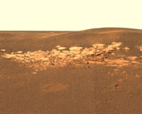
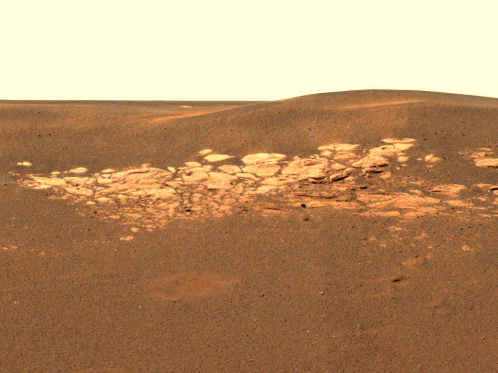
Pasadena - Jan 29, 2004 The first impression of the Opportunity landing site in color is the light, exposed area about ten meters from the rover's location inside a crater. The region has by now accumulated a plethora of adjectives and names: bizarre, alien, hummocky, layered, crater-rim, outcrop, stratigraphic slice, tabular, segmented, slabby. But what has scientists most intrigued is that the slabs are bedrock. Terrestrial bedrock exposed in state of Maine, US. In places like Arizona and Louisiana, depth to bedrock may be nearly a mile below the surface. Credit:Maine Geological Survey The literal foundation of Mars is its bedrock. Bedrock is the solid, intact part of the planet's crust. Whereas in comparison to terrestrial crust, parts of southern Arizona or Louisian may have thousands of feet of unconsolidated surficial material overlying bedrock, the depth to bedrock in a place like Maine ranges from ten to only a few hundred feet. Many of the more spectacular sites in Maine feature rugged bedrock exposed to view. To find bedrock is to know geologically that the history of this location is free from rock and boulder transport, mainly by wind, water, lava and impact debris. Whatever happened on Mars over billions of years, that hummocky slab bears its records. Steve Squyres, principal investigator for rover science, described the five exploration stages likely to follow in the next few weeks. While still perched on its base petal, the rover cameras will first snap panoramic color images in octets of 45 degrees each, until a full picture shows the surroundings. Without driving, the rover's pancam can probably get a good idea of the soil and rock surface composition, using its infrared capabilities to image circular aspects of the horizon in heat-sensitive colors. Called the mini-TES instrument, the main tool for this measures thermal emissions. The mobile laboratory will then drive off its station, maneuvering down a ramp and 40 cm drop (slightly more than a foot). The rover will look at the fine soil nearby, in hopes of finding out why this particular region is rare on Mars in being rich with iron-oxides. The surface soil's top layer is grey, much more grey than anything seen on Mars before. On the surface, Meridiani is the darkest color yet visited. But this dark layer gave way when the airbags were retracted revealing a deep maroon layer underneath. When summarizing the science activities by discipline, Steve Squyres noted that most of the group members--atmospherics, long-term planning, mineralogy, geology--are not fully engaged until the instrument suite is checked out and deployed on the surface. But "the soil physical properties group is having the most fun" speculating about how this maroon and grey landform came to be. Squyres described the competing theories as either "we have soil with two distinct components of coarse, grey grains on top of fine red soil--or we have aggregates that are grey but when squished, the red comes out. When certified to drive, the rover will explore the bedrock outcrop, while looking carefully for any layers or stratigraphic history. Since the rover is inside a crater (20 meters wide, 2-3 meters deep), the next step is probably to climb out. Depending on the soil texture, the rover is probably able to climb an embankment at a relatively steep 15 to 20 degree angle. As Squyres remarked: "We traveled 200 milllon miles or so to land in a crater. It was a hole-in-one." Since orbital images of the landing area shows three distinct color gradations, a first guess is that once outside this crater, the view will suddenly change to what is expected to be lighter colored soil. The brightest areas seen orbitally are the crater rims, followed by the flat plains, then the darkest interior to the craters, where Opportunity now is snapping charcoal-grey scenery. Since the horizon's range is mainly restricted to 10 meters for now, once outside this crater the startling picture of a dark grey Mars will likely change yet again. This second soil unit is brighter, perhaps from wind not apparent inside the craters, and will be looked at closely using the same diagnostics used on the crater floor and outcrop. Squyres said the science team then looks to "head for the big one"--a 150 meter wide crater, probably 10-15 meters deep at least and about half-a-mile away. The bright rim of that crater may well be another remnant of bedrock or something different altogether. How that driving spree will go looks promising so far. As pancam science lead, Jim Bell, described, where they can barely glimpse the horizon, it is flat and free of large rocks for five to six kilometers. This kind of "flat-out" driving terrain makes for fewer maneuvers to go the distance. Once they survey the real Meridiani plain outside their crater, they will gain some higher ground--about the height of an average person of five to six feet climbing out of a hole of similar depth. As JPL Center Director, Charles Elachi, pointed out on the night when Spirit first landed, the unique part of these missions is their multiplicity--not only two views of opposite sides of the planet, but also local mobility in which each science day that involves driving is comparable to a new landing. In 1976 Viking could only reach out and scratch the soil surface. The tiny Pathfinder rover could move between larger boulders, but had limited range. The Mars Exploration Rovers, with their mobile geology toolkit, are designed for the road. Article is courtesy of NASA's Astrobiology Magazine team at Ames Research Center. This article is public domain and available for reprint with appropriate credit. Related Links Mars Rovers at JPL Mars Rovers at Cornell SpaceDaily Search SpaceDaily Subscribe To SpaceDaily Express 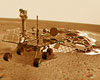 Washington - Jan 23, 2004
The US space agency NASA received a transmission on Friday from the troubled Mars rover Spirit, the first in two days, but the spacecraft is in a "critical state" and may not recover fully, officials said.
|
| ||||||||||
| The content herein, unless otherwise known to be public domain, are Copyright 1995-2016 - Space Media Network. All websites are published in Australia and are solely subject to Australian law and governed by Fair Use principals for news reporting and research purposes. AFP, UPI and IANS news wire stories are copyright Agence France-Presse, United Press International and Indo-Asia News Service. ESA news reports are copyright European Space Agency. All NASA sourced material is public domain. Additional copyrights may apply in whole or part to other bona fide parties. Advertising does not imply endorsement, agreement or approval of any opinions, statements or information provided by Space Media Network on any Web page published or hosted by Space Media Network. Privacy Statement All images and articles appearing on Space Media Network have been edited or digitally altered in some way. Any requests to remove copyright material will be acted upon in a timely and appropriate manner. Any attempt to extort money from Space Media Network will be ignored and reported to Australian Law Enforcement Agencies as a potential case of financial fraud involving the use of a telephonic carriage device or postal service. |