| . |  |
. |
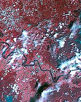
NASA science instruments and Earth-orbiting satellites are providing detailed insight about the environmental impact caused by Hurricane Katrina. Images and data are helping characterize the extent of flooding; damage to homes, businesses and infrastructure; and potential hazards caused by the storm and its aftermath. NASA, along with academic institutions and partner agencies, is working to ensure the Department of Homeland Security and the Federal Emergency Management Agency (FEMA) have the best available information to aid in responding to this catastrophic event. NASA's partner agencies in this endeavor include the U.S. Geological Survey (USGS), the National Oceanic and Atmospheric Administration (NOAA), the National Geospatial Intelligence Agency, the Environmental Protection Agency, and the U.S. Department of Agriculture. Coordinated assistance by numerous academic institutions and laboratories working under NASA grants will be employed by the Gulf Coast relief and recovery efforts to provide geospatial information useful to first responders and decision makers. NASA aircraft are providing detailed observations of the disaster area. The aircraft are taking high-resolution observations that can be used to assess the amount of damage to communities and the environment. For example at the request of USGS in cooperation with FEMA and the Army Corps of Engineers, NASA's Experimental Advanced Airborne Research LIDAR (EAARL) system is surveying the gulf coastline. The EAARL system, carried on a Cessna 310, surveyed the northern gulf coastline on Thursday. Tomorrow the aircraft is scheduled to fly over the perimeter and surrounding levee around New Orleans to assist in damage assessment of the system. While making its observations of the land, EAARL has the ability to "see" through vegetation, like trees and shrubs, to view the land underneath. Near the coast it can map the beach surface under water. This will help in the recovery of the shoreline infrastructure; determine hazard areas and environmental loss. The Terra, Aqua and Tropical Rainfall Measuring Mission (TRMM) satellites have already provided Earth observations for land cover and rainfall. Terra's Advanced Spaceborne Thermal Emission and Reflection Radiometer (ASTER) is providing data on the magnitude and extent of damage and flooding to the USGS Emergency Response Team through its Earth Resources Observation Systems Data Center in Sioux Falls, S.D. NASA's Moderate Resolution Imaging Spectroradiometer (MODIS) instrument on the Terra and Aqua satellites provided images of flooding, pre and post disaster comparisons. Data from NASA's QuikScat satellite was one source of wind observations used by NOAA's Hurricane Research Division to analyze the wind field of the storm and to track its path. Another NASA satellite in use is the Earth Observing Mission 1 (EO-1). The Advanced Land Imagery (ALI) multispectral instrument on EO-1 provided land use and land cover observations useful in determining hurricane damage areas and in aiding in recovery, response and mitigation. NASA satellites are used to improve weather predictions, to study climate and natural hazards. The knowledge gained during these missions aids assessment and recovery operations. Related Links SpaceDaily Search SpaceDaily Subscribe To SpaceDaily Express  Stennis MS (SPX) Sep 02, 2005
NASA has designated a telephone number (256/544-4700) for family members seeking information about people who may have sought shelter from Hurricane Katrina at NASA's Stennis Space Center in Mississippi and Michoud Assembly Facility near New Orleans.
|
| ||||||||||
| The content herein, unless otherwise known to be public domain, are Copyright 1995-2016 - Space Media Network. All websites are published in Australia and are solely subject to Australian law and governed by Fair Use principals for news reporting and research purposes. AFP, UPI and IANS news wire stories are copyright Agence France-Presse, United Press International and Indo-Asia News Service. ESA news reports are copyright European Space Agency. All NASA sourced material is public domain. Additional copyrights may apply in whole or part to other bona fide parties. Advertising does not imply endorsement, agreement or approval of any opinions, statements or information provided by Space Media Network on any Web page published or hosted by Space Media Network. Privacy Statement All images and articles appearing on Space Media Network have been edited or digitally altered in some way. Any requests to remove copyright material will be acted upon in a timely and appropriate manner. Any attempt to extort money from Space Media Network will be ignored and reported to Australian Law Enforcement Agencies as a potential case of financial fraud involving the use of a telephonic carriage device or postal service. |