| . |  |
. |
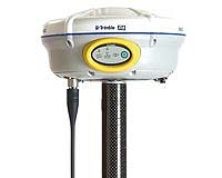
Trimble has introduced five surveying products as part of its new Connected Survey Site model - the Trimble GX 3D Laser Scanner; the Trimble R8 system (pictured) with Global Navigation Satellite System (GNSS) capabilities; the Trimble M3 Total Station; the Trimble R3 GPS System; and the Trimble S6 Total Station with GPS Search. The new positioning products add greater flexibility and versatility to provide seamless and streamlined workflow for all of the critical phases of surveying. The announcement was made today at INTERGEO 2005, the world's largest conference on geodesy, geoinformatics and land management. "Each of our new products is an important part of Trimble's Connected Survey Site model, which empowers surveyors with ultimate flexibility and connectivity while on the job," said Jurgen Kliem, general manager for Trimble's Survey Division. "The Trimble survey product portfolio is a complete, compatible set of tools built with the latest positioning technologies designed to seamlessly streamline and automate the surveyor's workflow. The Connected Survey Site provides the surveyor with total flexibility to choose just the right tools for each survey task. From robotic and mechanical total stations to real-time kinematic GPS systems and 3D laser scanning to precise leveling systems, everything a surveyor needs for any project is available from a single source."
The Connected Survey Site Trimble's Connected Survey Site model creates powerful working relationships among all Trimble products, technologies and services including support, infrastructure and partnerships. Taking Integrated Surveying to the next level, the Connected Survey Site enables surveyors to choose from a broad range of options; including surveying techniques, communications channels and facilitating services such as GPS infrastructure in one fully integrated and interoperable surveying solution. Surveyors benefit from complete data compatibility with all Trimble field and office software; increased flexibility in employing the best tools and techniques for the job at hand; the adaptation of specialized technologies to fit the ideal workflow of surveyors; and the localization of surveying solutions to address specific market needs throughout the world.
Trimble GX 3D Laser Scanner As the first 3D laser scanner to offer a true surveying workflow, the new Trimble GX scanner "thinks like a surveyor" with features that include flexible power supply options, station setup and a surveying data collector. The scanner's surveying workflow provides significant benefits such as faster and fewer setups, easy portability, smooth interaction with other surveying systems such as optical and GPS instruments, and a quick learning curve for fast productivity and return on investment. The Trimble GX scanner suits both surveying and typical scanning applications. The scanner can save significant human resource costs on many traditional surveying jobs. Real-time autofocus collects highly precise data in a short time: a 360 degree servo-driven system scans indoors and outdoors up to 200 meters. For jobs requiring less detail but longer range, Trimble's OverScan technology increases data acquisition capability up to 350 meters, which allows fewer setups for shorter survey times as well as the ability to scan larger objects. The Trimble GX scanner is supported by Trimble's PointScape and PocketScape field software; and in the office by Trimble RealWorks Survey software for processing and analysis of point cloud data.
Trimble R8 System with GNSS Support Powered by enhancements to Trimble R-Track technology, the new Trimble R8 GNSS system now supports both the new L2C and coming L5 GPS Modernization signals. When transmitted, these new signals will be capable of providing surveying professionals with real field benefits. The Trimble R8 GNSS system includes a new RTK engine which is optimized to provide top performance with the new signals. With the world's satellite systems in constant development, surveying businesses small and large can be confident that investment in a Trimble GNSS system is protected. From the powerful Trimble field software to the receiver itself, the Trimble R8 GNSS system's overall design has been tried, tested, and proven. As a rover it is rugged, lightweight and cable free for superior ergonomics in the field. As a base it is flexible and also cable free. The Trimble R8 GNSS system's flexible communication options include: an internal receive/transmit 450 MHz radio option and an internal GSM/GPRS option for Internet connectivity.
Trimble M3 Total Station The new Trimble M3 Total Station is an extremely rugged and accurate mechanical instrument built to handle the toughest surveying applications. Focusing direct reflect (DR) technology enables a single surveyor to make long-distance, reflectorless measurements quickly and safely with confidence that the intended target is what is actually being measured. An optimal plummet in the alidade expedites setup and ensures the highest accuracy possible at both 3" and 5" accuracy. The long-lasting battery offers two workdays of typical measurement activities and a large internal memory stores several days of data collection. Extremely user friendly, the Trimble M3's easy-to-learn software and workflow enables users to quickly attain optimal productivity.
Trimble R3 GPS System The new Trimble R3 GPS System integrates an L1 survey-grade receiver with the popular Trimble Recon Controller, a proven, ultra-rugged PDA. The system includes field and office software to provide a complete solution to bring precise, sub-centimeter control to survey operations, establish new localized control and collect topographic data. Users can perform Static, FastStatic and Kinematic surveys on short to moderate baselines quickly and easily. The Trimble Recon Controller runs the Microsoft Windows Mobile for Pocket PC operating system along with the Trimble Digital Fieldbook software. With familiar software options, menus and terminology, even new users can achieve maximum productivity in a short time. In addition, the new Trimble Business Center Office software is a sophisticated, user friendly solution for postprocessing, analysis, and adjustment of L1 GPS survey data. Trimble S6 with GPS Search With the new GPS-aided search capability for the Trimble S6 Total Station, the surveyor can locate and lock onto targets even faster. By using a simple, consumer-grade GPS receiver connected to the field survey software at the robotic rover, the system provides fast, confident search and lock on the robotic rover. This combination of GPS and optical technologies results in greater speed and productivity for the surveyor using Trimble systems. This rapid search capability is available with the Trimble Field User Interfaces. Related Links SpaceDaily Search SpaceDaily Subscribe To SpaceDaily Express  New York NY (SPX) Oct 05, 2005
2-Track Global has announced that it had commenced the commercial launch of its Condor 505 Personal GPS Tracker. This product has been specifically designed for the safety and security of People in the hazardous areas, elders as well as children.
|
| ||||||||||
| The content herein, unless otherwise known to be public domain, are Copyright 1995-2016 - Space Media Network. All websites are published in Australia and are solely subject to Australian law and governed by Fair Use principals for news reporting and research purposes. AFP, UPI and IANS news wire stories are copyright Agence France-Presse, United Press International and Indo-Asia News Service. ESA news reports are copyright European Space Agency. All NASA sourced material is public domain. Additional copyrights may apply in whole or part to other bona fide parties. Advertising does not imply endorsement, agreement or approval of any opinions, statements or information provided by Space Media Network on any Web page published or hosted by Space Media Network. Privacy Statement All images and articles appearing on Space Media Network have been edited or digitally altered in some way. Any requests to remove copyright material will be acted upon in a timely and appropriate manner. Any attempt to extort money from Space Media Network will be ignored and reported to Australian Law Enforcement Agencies as a potential case of financial fraud involving the use of a telephonic carriage device or postal service. |