| . |  |
. |
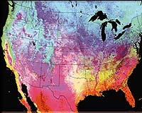
Thales announced Monday the introduction of Magellan MapSend Topo 3D USA software; a powerful, seamless map database with topography, street detail and thousands of searchable points of interest (POIs) for the 48 contiguous United States and Hawaii. Mondays' announcement represents three "firsts" for the consumer GPS market. MapSend Topo 3D USA is the:
"MapSend Topo 3D USA joins a wide range of Magellan software solutions that uniquely tailor the functionality of a Magellan GPS receiver to meet people's specific needs for their favorite outdoor activities," said John Parrott, manager of cartography for Magellan content and mapping products. "It delivers an extensive array of tools and information, both at the desktop and in the field, for explorers who want to take the guesswork out of navigating unknown terrains." On a PC, MapSend Topo 3D USA provides a simple, one-click switch from a detailed, searchable, two-dimensional map view to an interactive, three-dimensional view. The 3D view on a PC allows customers to rotate, tilt, customize and explore a geographical area to gain a thorough understanding of the terrain. Outdoor enthusiasts can save and transfer waypoints and routes to and from a PC and GPS receiver. Navigators can find trails, natural landmarks, street addresses and more from a searchable database containing thousands of urban and outdoor destinations. When downloading MapSend Topo 3D USA to a compatible Magellan GPS receiver, customers can select the exact map areas they want and change the map region as often as needed. When using an optional industry standard Secure Digital (SD) memory card to store data for the GPS, users can load a detailed map area as large as the state of Washington on a 64MB SD card, for example, or fill a 240MB SD card for access to areas roughly the size of California, Nevada, Oregon and Washington combined. Viewed on the GPS receiver, the software provides a clear, crisp two-dimensional rendering of the surrounding terrain with topographical contours that redraw quickly as the customer moves to a new position or changes the map view zoom level. It also provides elevation profiles of routes, tracks, roads, streams, and more. In addition, users can create and edit waypoints, routes and tracks on a Magellan handheld GPS then download them to a PC when they return from an adventure. Likewise, customers can transfer customized data from a PC to a GPS receiver. By default, uploaded maps include topographic contours, waterways, POIs and detailed street maps. However, users can also customize this detail to suit their needs from three complete, integrated sets of must-have, searchable POIs:
Trails.com Navigators can download applicable information to their GPS receiver or access it on their PC. On the PC, each Trails.com POI can link to the website pages that relate to that destination. There, users will find helpful information about each destination, including the mileage of each specific hike, the degree of difficulty, the approximate amount of time to complete the hike and interesting things to look for along the way. Those who subscribe to Trails.com will gain additional information, including key route statistics, driving directions, skill-level ratings, real-time weather, user reviews and more. They can also preview, download and print guidebook chapters and USGS quad maps, and upload waypoints to a Magellan receiver. To provide these additional benefits, Trails.com will offer a free, introductory, three-month trial subscription to Magellan customers who purchase Magellan MapSend Topo 3D USA. "This partnership between Trails.com and Thales will provide an unprecedented solution for customers," said Rob Holmes, Trails.com co-owner and director of marketing. "The pairing of these interactive navigation and recreation resources gives customers the trip-planning tools they need to maximize their outdoor adventures and take full advantage of everything nature has to offer."
NavTeq Users can search by street name or address on a GPS receiver to see the street location of an address on the map, and can also save the location as a waypoint and use it as a destination for point-to-point routing.
U.S. Geological Survey Customers can preview these features and experience the software's benefits with the MapSend map viewer available at www.magellangps.com/webviewer . MapSend Topo 3D USA is licensed for use with one Magellan GPS receiver, and is compatible with Magellan Meridian Color, Platinum, Gold, and Marine as well as the SporTrak Color, SporTrak Pro, SporTrak Pro Marine and SporTrak Map. Other MapSend solutions include the all-new MapSend Lakes USA, MapSend Topo Canada MapSend DirectRoute North America, Magellan MapSend BlueNav, and international titles. Related Links Thales Magellan SpaceDaily Search SpaceDaily Subscribe To SpaceDaily Express  San Diego CA (SPX) Dec 10, 2004
Air-Trak, Inc., a developer of the Cloudberry GPS tracking and communication system, announced today that Vertrax has chosen Cloudberry as a foundation for its SmartTrax mobile resource management solution for the retail petroleum industry.
|
| |||||||||||
| The content herein, unless otherwise known to be public domain, are Copyright 1995-2016 - Space Media Network. All websites are published in Australia and are solely subject to Australian law and governed by Fair Use principals for news reporting and research purposes. AFP, UPI and IANS news wire stories are copyright Agence France-Presse, United Press International and Indo-Asia News Service. ESA news reports are copyright European Space Agency. All NASA sourced material is public domain. Additional copyrights may apply in whole or part to other bona fide parties. Advertising does not imply endorsement, agreement or approval of any opinions, statements or information provided by Space Media Network on any Web page published or hosted by Space Media Network. Privacy Statement All images and articles appearing on Space Media Network have been edited or digitally altered in some way. Any requests to remove copyright material will be acted upon in a timely and appropriate manner. Any attempt to extort money from Space Media Network will be ignored and reported to Australian Law Enforcement Agencies as a potential case of financial fraud involving the use of a telephonic carriage device or postal service. |