| . |  |
. |
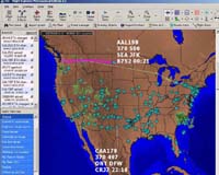
Flight Explorer, a provider of Internet-based real-time flight tracking and weather information, reporting and display products, Monday announced that, under an agreement with NAVTEQ, a global provider of digital maps for vehicle navigation and location-based solutions, Flight Explorer customers can now track the real-time location of aircraft relative to the road network of the United States and Canada and points of interest including hospitals, waterways and other relevant locations. NAVTEQ maps offer the accuracy and reliability required to enhance Flight Explorer's flight tracking solutions. Using proprietary technology and collection methods, NAVTEQ field analysts collect and link the elements of the road network with its corresponding latitude and longitude. This process, known as geocoding, results in the accurate alignment of streets, intersections, addresses and many other features with their relative locations on the earth. With NAVTEQ maps integrated into Flight Explorer Professional - the company's flagship product - the solution gives users a greater situational awareness of their aircraft in conjunction with other assets. By using Flight Explorer's proprietary interfaces and NAVTEQ maps, positional information for trucks, cargo, etc. can be displayed providing a common operating picture of all assets relative to the US and Canadian road network. "We are seeing more and more solution providers using location information to enhance or expand their product lines. Flight Explorer recognized an opportunity to improve the robustness of their core product and turned to NAVTEQ to play a key role in this enhancement. It's a great opportunity for both companies to bring added value to new and existing customers," commented Winston Guillory, Senior Vice President - North American Sales. Walt Kross, CEO of Flight Explorer, said, "NAVTEQ maps add a whole new dimension to Flight Explorer products, making them about as close to an all- in-one tool as is possible for pilots and dispatchers." "The map overlays will enable customers to pinpoint the location of an aircraft and other assets relative to familiar landmarks. This is a huge plus for all users, but especially helicopter operators, air medical and government organizations." Related Links Flight Explorer NAVTEQ SpaceDaily Search SpaceDaily Subscribe To SpaceDaily Express  Sunnyvale CA (SPX) Sep 09, 2004
Trimble introduced today a new ultra-low power miniature Global Positioning System (GPS) receiver - the Lassen iQ module for mobile devices. With major advancements in performance, sensitivity and power consumption, the Lassen iQ module enables system integrators to easily add GPS capability to mobile devices at a very economical price.
|
| ||||||||||
| The content herein, unless otherwise known to be public domain, are Copyright 1995-2016 - Space Media Network. All websites are published in Australia and are solely subject to Australian law and governed by Fair Use principals for news reporting and research purposes. AFP, UPI and IANS news wire stories are copyright Agence France-Presse, United Press International and Indo-Asia News Service. ESA news reports are copyright European Space Agency. All NASA sourced material is public domain. Additional copyrights may apply in whole or part to other bona fide parties. Advertising does not imply endorsement, agreement or approval of any opinions, statements or information provided by Space Media Network on any Web page published or hosted by Space Media Network. Privacy Statement All images and articles appearing on Space Media Network have been edited or digitally altered in some way. Any requests to remove copyright material will be acted upon in a timely and appropriate manner. Any attempt to extort money from Space Media Network will be ignored and reported to Australian Law Enforcement Agencies as a potential case of financial fraud involving the use of a telephonic carriage device or postal service. |